
Study of Landslides & their Relation to Engineering & Planning in the former Shire of Narracan
|
Landslides of the slump-earth type are common in areas of strongly undulating terrain in the Strzelecki Ranges south of Trafalgar in the West Gippsland region. Failures occur each winter following heavy rains that trigger movement in the clay rich residual soil slopes. This report: "A Study of Landslides and their Relation to Engineering and Planning in the Southern Districts of the Narracan Shire, Victoria (1979)" examines the nature and distribution of landslides, the properties of the soils involved and the factors responsible for slope instability. The report also provides suggestions for mitigating the existing and potential landslide hazards. The study area is a part of the Strzelecki Ranges bounded approximately by Yarragon, Trafalgar, Moe, Narracan and Mirboo North - part of the former Shire of Narracan. The former Shire had a major problem in controlling landslides that intercepted numerous roads in the area - and in 1977 requested the former Department of Minerals and Energy to undertake a study in the area with a view to more effective control, prevention and avoidance of local landslide problems. The study was undertaken by J.C. Brumley of the former Department of Minerals and Energy in 1978 and this final report was prepared as part of an Unpublished Report series. | 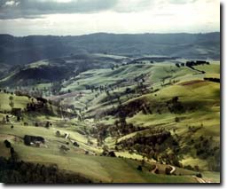 |
To view the information PDF requires the use of a PDF reader. This can be installed for free from the Adobe website (external link).
© State of Victoria (Agriculture Victoria) 1996 - 2025.

This work, Victorian Resources Online, is licensed under a Creative Commons Attribution 4.0 licence. You are free to re-use the work under that licence, on the condition that you credit the State of Victoria (Agriculture Victoria) as author, indicate if changes were made and comply with the other licence terms.
The licence does not apply to ‘branding’ or some ‘images or photographs’ that may be owned by third parties. We ask you to seek prior approval to use images using the VRO feedback form. Access to higher quality images can also be provided on request.
This page was last updated on 25/01/2019.