
Declared Special Water Supply Catchments Areas in West Gipsland
Back to: Declared Special Water Supply Catchments Areas in Victoria
Many catchments supplying water for domestic, irrigation or other purposes within Victoria are protected under the Catchment and Land Protection Act 1994. These catchments have significant values as a source of water supply, both for domestic and for stock and domestic use. This information assists planners and those managing land disturbance or development activities to readily determine the suitability of proposed activities within these catchment areas. Once a catchment is 'Declared', approvals for activities conducted under other statutes and statutory planning schemes must be referred to the responsible land management authority (water authority, CMA or DELWP).
| This map shows the location of Declared Special Water Supply Catchment Areas in the West Gippsland region. The table below provides links to legacy documents associated with these catchments. | 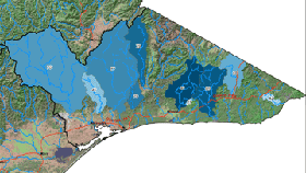 |
Declared Special Water Supply Catchments Areas throughout the West Gippsland region include:
© State of Victoria (Agriculture Victoria) 1996 - 2025.

This work, Victorian Resources Online, is licensed under a Creative Commons Attribution 4.0 licence. You are free to re-use the work under that licence, on the condition that you credit the State of Victoria (Agriculture Victoria) as author, indicate if changes were made and comply with the other licence terms.
The licence does not apply to ‘branding’ or some ‘images or photographs’ that may be owned by third parties. We ask you to seek prior approval to use images using the VRO feedback form. Access to higher quality images can also be provided on request.
This page was last updated on 11/04/2019.