
Historical Geography and Landscape change in the Costerfield District
European Settlement | Deforestation | Local Climate | Bushfires | Gold Mining | Introduced Animals | Land Degradation | Conclusions | References
Costerfield is located 100 km north of Melbourne and the average annual rainfall is approximately 575 mm. The land is generally used for sheep grazing and the topography includes undulating rises, gentle slopes and drainage depressions (see Land Degradation near Costerfield). Prior to clearing by European settlers the landscape was ominated by Eucalyptus spp. The soils are typically duplex (i.e. strong texture contrast, sodium-affected to some degreee and are classified as Sodosols, Kurosols and Chromosols (Isbell 1996) so that they slake and disperse. A sparse cover of unimproved native grasses is evident in the photograph below.
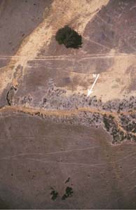 A low altitude view of severely eroded landscape featuring tunnel and gully erosion near Costerfield. The canopy of the large tree is approximately 15 m. Photograph: Stuart Boucher (PDF 131KB) | The area forms part of the Western uplands Geomorphic Region. The site characterics have been discussed elsewhere on the website (see Tunnel Hydrology near Costerfield). By establishing the nature of the semi arid climate in relation to teh chaning vegetative cover and soil disturbance, it was possible to explain the conditions surrounding the onset of tunnel initiation: i.e. how rainfall entered the subsoil in sufficient volumes to create tunnels. In essence, the landscape was formerly covered by a dense tree cover (as evidenced by the remnant stumps throughout), has a low carrying capacity for livestock and is characterized by low-fertility soils that are being eroded from both the surface and subsurface by sheet, rill, tunnel and gullyflow (Boucher 2002). What were the circumstances that caused the onset of such land degradation? Features evident in the above plate include:
|
To view the information PDF requires the use of a PDF reader. This can be installed for free from the Adobe website (external link). |
The Heathcote-Costerfield district, located approximately 100 km north of Melbourne, was appropriate for a number of reasons:
- It was part of a large pastoral run established in the 1830s and for which there exists detailed documentation;
- It was possible to obtain historical data covering the changes in landscape from the large run to relatively small allotments, with particular reference to changing vegetative cover and soil disturbance;
- It was possible to obtain original meteorological records to ascertain the nature of the semi-arid climate and the potential impacts it had on the changing landscape. Heathcote is the nearest Bureau of Meteorology station to Costerfield and the local newspapers were based in McIvor, as Heathcote was originally known.
- It was a centre of mining during the gold rush in the 1850s;
- It has a long history of land degradation that can be traced to European settlement; and
- The various data can be used to trace a chnage in pressures imposed upon the local environment by introduced land uses.
The contents of this weries of articles includes maps, survey plans, quotes and the original historical data were corroborated by newspaper reports. It should be noted that complete detailed original historical cata are often difficult to obtain owing to damage during storage since the time of collection and various other factors.
It is intended to reconstruct the environment in the Heathcote-Costerfield district from the time of European settlement using historical records, with a view to:
1) establishing the location of two clusters of allotments with a history of tunnel erosion, and only several km apart, with respect to the first stations in the Port Phillip district; and
2) laying the foundations required to make inferences as to the likely timing of tunnel initiation.
Related articles to follow include:
© State of Victoria (Agriculture Victoria) 1996 - 2025.

This work, Victorian Resources Online, is licensed under a Creative Commons Attribution 4.0 licence. You are free to re-use the work under that licence, on the condition that you credit the State of Victoria (Agriculture Victoria) as author, indicate if changes were made and comply with the other licence terms.
The licence does not apply to ‘branding’ or some ‘images or photographs’ that may be owned by third parties. We ask you to seek prior approval to use images using the VRO feedback form. Access to higher quality images can also be provided on request.
This page was last updated on 23/03/2020.