
Victorian Land Use Information System (VLUIS)
Introduction
The Victorian Land Use Information System (VLUIS) dataset has been created by the Spatial Information Sciences Group of the Agriculture Victoria Research Division in the former Department of Environment and Primary Industries Victoria. The method used to create VLUIS is significantly different to traditional methods used to create land use information and has been designed to create regular and consistent data over time. It covers the entire landmass of Victoria and separately describes the land tenure, land use and land cover for each cadastral parcel across the state. The land cover data is sourced (created) annually whilst the land tenure and land use data is available bi-annually. This means that the VLUIS 2010 dataset is comprised of 2010 land tenure, use and cover information, while there is only land cover information updated in 2011. The same applies for the 2006/07, 2008/09, 2012/13 and 2014/15 datasets, with each dataset having only one year of land tenure and use and two years of land cover information. From 2016, the VLUIS will be published annually highlighting known changes to land use and land tenure from the previous year's publication together with a complete update of mapped land cover.
The data is in the form of a both a table and a feature class. The table contains a Parcel_PFI column which links to the same code within the state-wide cadastral data layer so that data on land use, land tenure and land cover is attached to each land parcel.
VLUIS is a key contextual land use information set answering three critical questions
What (is the land tenure, use and cover)? | Where (is the land tenure and cover)? | When (was the land tenure, use and cover present)? |
This makes the data useable for an extensive range of application in government, university and industry groups.
Land tenure is the form of an interest in land. Land use means the purpose to which the land cover is committed. VLUIS uses the Australian Valuation Property Classification Code (external link) to classify land use. Land cover refers to the physical surface of the earth, including various combinations of vegetation types, soils, exposed rocks and water bodies as well as anthropogenic elements, such as agriculture and built environments. Land cover classes can usually be discriminated by characteristic patterns using remote sensing.
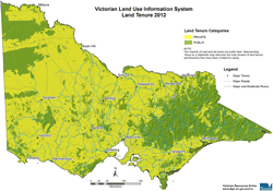 Map 1: VLUIS 2012 Land Tenure | 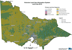 Map 2: VLUIS 2012 Land Use | 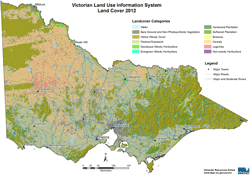 Map 3: VLUIS 2012 Land Cover |
Implications/Benefits
The Victorian Land Use Information System dataset is not about supporting compliance – it is a strategic product. The dataset will collect and maintain only the basic “what, where and when” of land information and provide this in an accurate and consistent manner. Therefore, the dataset is not limited to any particular use case and instead supports many uses by answering key questions often only a few steps removed from the question being asked.
Potential uses of land use/cover and management information
The potential uses of reliable and repeatable land use, land cover and land tenure dataset are endless. The land use dataset can answer basic questions about the number, distribution or composition of land uses, land covers and tenures, which can then lead to more strategic questions and objectives
The Victorian Land Use Information System (VLUIS) Metadata description
A copy of The Victorian Land Use Information System (VLUIS) Metadata description (external link) is available to read online
Potential uses of land use information
The potential uses of reliable and repeatable land use, land cover and land tenure dataset are endless. Through the provision of a package of data relating to any size area of interest (from mesh block to state-wide) the land use dataset will answer basic questions about the number, distribution or composition of land uses, land covers and tenures, which can then lead to more strategic questions and objectives.
Victorian Land Use Information System | ||||||
Will provide a package of data that will answer a range of spatial questions... | ||||||
What is the land use, land cover and land tenure and where? Using multiple dates - are these - changing in composition and space over time? Is this change significant? Why is this change? | Where are the critical biodiversity assets? What is the surrounding land use/cover? Is the land use/cover changing? What are the greatest risks to the preservation of these critical assets? | Where are all the dry land cropping farms? How much area is under cereals? How much area was under fallow in 2001? What is the erosion risk? | What land cover exists in rural residential areas and surrounds? Is this a fire risk? | |||
...in any area of interest (Shire, CMA, mesh block) | ||||||
VLUIS is used by
The former Department of Environment and Primary Industries
- Land use impact model
- Catchment simulation of nutrient dynamics
- Vine yard mapping (Biosecurity Victoria)
- Dairy farm mapping (former Farm Services Victoria)
- Enterprise profitability and flexibility (former Farm Services Victoria)
- Securing priority riparian areas
- Index of wetland condition assessments
- Assessment of Biolink and Flagship areas
- Vineyard grower notification of planned burning.
Catchment Management Authorities
- Planning and management
- Hydrological mapping
Department of Planning and Community Development
- Audit of green wedge land
- Regional land use plan
Data
Extended metadata and symbology files for the data have been made available.
The Victorian Land Use Information System (VLUIS) Metadata description (300 KB - PDF) has been provided as an online Word document.
The Victorian Land Use Information System (VLUIS) Shape files have been proved as a LYR files.
- VLUIS - Land use primary (12 KB - LYR file)
- VLUIS - Land use secondary (12 KB - LYR file)
- VLUIS - Land cover post 2009 (84 KB - LYR file)
VLUIS 2006/7 DOI 10.5061/dryad.n08t0
VLUIS 2008/9 DOI 10.5061/dryad.n08t0
VLUIS 2010/11 DOI 10.5061/dryad.n08t0
VLUIS 2012/13 DOI 10.5061/dryad.n08t0
VLUIS 2014/15 DOI 10.4226/92/58e72ebae5380
VLUIS 2016 DOI 10.4226/92/590abbe6ea3f1
Land cover 2015 DOI 10.4226/92/58e732125d9d0
Land cover 2016 DOI 10.4226/92/590aba615a44d
Awards
2011 Asia-Pacific Spatial Excellence Awards - Industry 2011 - Spatially Enabled Government
7th Annual Victorian Spatial Excellence Awards: Spatially Enabling Government Award
© State of Victoria (Agriculture Victoria) 1996 - 2025.

This work, Victorian Resources Online, is licensed under a Creative Commons Attribution 4.0 licence. You are free to re-use the work under that licence, on the condition that you credit the State of Victoria (Agriculture Victoria) as author, indicate if changes were made and comply with the other licence terms.
The licence does not apply to ‘branding’ or some ‘images or photographs’ that may be owned by third parties. We ask you to seek prior approval to use images using the VRO feedback form. Access to higher quality images can also be provided on request.
This page was last updated on 14/07/2021.