
European Settlement - Costerfield District
According to a transcript taken from a book written by Major Sir Thomas Mitchell, the summary title being 'Three expeditions into the interior of eastern Australia' (1838), the Surveyor General of NSW entered the future Shire of McIvor on 5 October 1836 (Randell 1985). Despite the evidence of bullock tracks recorded in Mitchell's journal on 23 September, some 12 days prior to his crossing of the Campaspe River, he and his party were recognised as the first Europeans having traversed what was to become the 'Campaspe Plains' (Randell 1985). The term 'Campaspe' was also written as 'Campaspie' in the early days of white settlement (Randell 1982). Upon contact with Aborigines on 7 October, he was informed that the waterway flowing through the valley was known as 'Deegay' (Randell 1985), [also known as 'Dungay' (Randell 1982) or 'Degay Ponds'], the upper extremities of which (near Heathcote) were later renamed the 'Wapentake' (or 'Wappentake') Creek (Randell 1982). It was stated in the correspondence of Captain Charles Hutton on 6 June 1839 to Captain William Lonsdale (who was in charge of the Port Phillip Settlement), that the tribesmen were from the Goulburn River (Randell 1982). Although conflict between the white settlers and Aborigines had ceased long before the discovery of gold long McIvor Creek in 1852, it was reported in The McIvor Times and Rodney Advertiser newspaper in October 1866 that only five or six of the natives from the '....once mighty Goulburn River Tribe ......' remained in the district (Randell 1985, 34). In a letter to Lieutenant-Governor Charles La Trobe dated 19 August 1853, Captain Hutton wrote that the only other tribe he know of in the area was based near the Campaspe River (Hutton 1853). According to Figure 13 in Clair (1998), both native tribes belonged to the 'Daung Wurrung' clan ("named group").
Randell (1982) noted that Hutton and his party of men including eight convicts, bullocks, drays, horses and sheep travelled overland from Bundanon Estate (between Goulburn and Nowra) in late January or early February 1838. They followed Major Mitchell's track and arrived on the Campaspe Plains in July 1838 (Hutton 1853). The group camped on the upper reaches of Wild Duck Creek for approximately a month whilst exploring the surrounding land prior to shifting between 5 miles and 6 miles (8 km to 10 km) downstream, where he established a headstation on the west bank which later become the 'Langwornar' Station homestead (Randell 1982). This station was located in the centre of the future Shire of McIvor and therefore Hutton could be considered as its first resident (Randell 1985). The term 'Campaspie Plains' was not restricted to Hutton's run and also applied to the lower reaches of the river from Darlington Station to where it joined the Murray River (Randell 1982). Theoretically, the vast initial run was estimated to be 400 000 acres (i.e. approximately 162 000 ha) owing to the lack of other claimants, although for practical purposes the area would have been considerably reduced because of the unreliable water supply from smaller creeks located away from the Campaspe River and Wild Duck Creek (Randell 1982). The land within the original station underwent a succession of owners and boundary definitions which were documented by Spreadborough and Anderson (1983). An application for lease of the station was made under the Order in Council of October 1847 (Randell 1982). The area squatted upon by Daniel Jennings was surveyed and estimated to comprise 144 900 acres (i.e. approximately 58 660 ha) with a grazing capacity for 20 000 sheep.
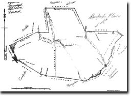
| Degay Ponds are marked as part of the eastern boundary of the station and other nature features marked include the Campaspe River, Mosquito Creek, McIvor Creek and various areas of pasture and timber cover. This map is Copyright (c) Crown (State of Victoria) 2006. All rights reserved. It has been reproduced with the permission of the Surveyor General, Victoria. |
Randell (1982) reported that the process of subdivision commenced in late 1852, approximately two months prior to the advent of the McIvor gold rush. He also recorded that Derrinal Station, which comprised an estimated 25 000 acres (i.e. approximately 10 120 ha), was sold by John Hunter Patterson to William Speed in July 1853, and estimated that the combined leasehold area of the three stations retained by Patterson was in the order of 120 000 acres (i.e. approximately 48 580 ha). The Moorabbee and Kimbolton pastoral runs were subject to a 14 year lease, being located in the
'Unsettled District' (Randell 1985, 30). Further information on the divisional structure of regions was provided by Powell (1970).
Randell (1982, 299) noted that Daniel Jennings and George Playne bought Campaspe Plains Station from Charles Hutton in the period late 1839-early 1840 and, at that time when Aboriginies were stealing sheep, it was '...... the absolute pastoral frontier ... their being no stations on the Campaspe River below them.' He also stated (1982, 302) that, although Hutton had withdrawn his outstations owing to the murder of two shepherds by Aborigines in May 1839 and another employed by Jennings and Playne in July 1840, the reduced grazing area available owing to the establishment nearby of Barnedown Station in late 1840 '... would have had little effect as the country was then so lightly stocked ...'. Randell (1982, 296) quoted a passage from the diary of George A Robinson, the Chief Protector, written in January 1840, and it is reproduced as follows:
| ... When leaving this forest belt, and opening out upon the plain, the change of scent was delightfully pleasant. Where Mt Hutton's house stands is a beautiful sight, with extensive plains before it and some thousands of acres of good sheep country, mainly open forest hills, extending tens of thousands of acres on every side..... Two large paddocks were fenced in with split post and rail, two rails. One, a paddock of wheat, had been reapeda dn stacked and they were thatching it. The wheat appeared very good. This must be a great saving, to grow wheat on their establishments. It also proves the climate and soil. Mr Hutton thinks once crop out of three years may succeed, but this is mere conjecture..... |
In terms of vegetative cover as of 1848, the Campaspe Plains Station varied considerably. Some descriptions marked on the above diagram include areas of 'stony ranges', 'thickly wooded', 'good pasture', 'very little pasture', 'very stony', 'Box and Stringy Bark' and 'thickly wooded with Box and Iron Bark'. It is clear that the allotments referred to in the section on 'Deforestation' were contained within the Campaspe Plains Station and, following subdivision, Mooabbee Station as they were to the west of 'Sir T L Mitchell's line of Road' which became 'Majors Line Road' (Royal Australian Survey Corps 1987). As of 1848, the area which was to become Moorabbee Station was marked on the above diagram as a broad acre of 'good pasture' with 'Box and Stringy Bark' to the north. A detailed history of Moorabbee Station was written by Randell (1982) and the following description was printed in The Argus newspaper on 11 January 1854.
| ...The site of Moorabbee is one of the most magnificent in Victoria: it stands on a most elevated position, commanding a noble view, for many miles of the sylvan scenery around..... |
Data indicating grazing intensities for the period 1852-55 are provided in the following table and it can be seen that there was a sharp increase in the numbers of stock carried during 1853. This was most likely associated with supplying food for the rapid rise in population caused by the recently discovered McIvor goldfield. Randell (1985) noted that since the beginning of 1853, a valuable part of the goldfield was situated on Derrinal Station. The much larger numbers (i.e. between 200 000 and 300 000 sheep) referred to by Charles Hutton in August 1853 related to the Lower Campaspe Plains.
Numbers of livestock on the area occupied by Campaspe Plains Station 1852-55
Year | Horses | Cattle | Sheep |
18521 | 20 | 100 | 28 000 |
18532 | 50 | 500 | 44 200 |
18541 | 8 | 50 | 20 024 |
18551 | 15 | 90 | 26 242 |
1 Parliamentary Report on Crown Lands (Randell 1982, 311).
2 Return of Livestock 1 January 1853, Pastoral Run Paper No. 203 Campaspie Plains
Powell (1970, 1976, 1989) noted that a series of Land Selection Acts was introduced in the Australian colonies between 1860 and the mid-1880s to facilitate settlement of the small-scale 'yeoman' farmer. Squatting formally ceased as a result of the Victorian Land Act of 1884, which encompassed the whole Colony apart from the Mallee, and was based on a scheme of land classification according to reports made by district surveyors (Powell 1970).
© State of Victoria (Agriculture Victoria) 1996 - 2025.

This work, Victorian Resources Online, is licensed under a Creative Commons Attribution 4.0 licence. You are free to re-use the work under that licence, on the condition that you credit the State of Victoria (Agriculture Victoria) as author, indicate if changes were made and comply with the other licence terms.
The licence does not apply to ‘branding’ or some ‘images or photographs’ that may be owned by third parties. We ask you to seek prior approval to use images using the VRO feedback form. Access to higher quality images can also be provided on request.
This page was last updated on 23/03/2020.