
Strathdownie Land System
|
|
|
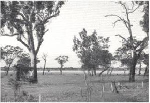 Plate 9 - The Strathdownie land-system (Coastal plain consisting of extensive swamps surrounded by woodlands of swamp gum and red gum and a few stringybark scrubs.) | Early descriptions of the Western District made mention of extensive swamplands near the South Australian border where the regional drainage is so slow that in winter the numerous swamps coalesce to make the area virtually one huge swamp. A number of circumstances combine to give this picture. The regional drainage has been impeded by long lines of Pleistocene indurated calcareous dunes lying across the fall of the land; the local drainage is slow because the chief parent material, being Pleistocene and Holocene lagoon deposits, is relatively flat, and finally, the internal drainage of the chief soils, which have an impeding horizon at shallow depth, is so slow that most of the water is retained at or near the surface. The Strathdownie land-system is the country where all these conditions are typical.
It covers about 160,000 acres, and 92 per cent of this, 147,000 acres, is alienated, and the rest is chiefly Crown land of various forms. Extending in a broad band in a generally north-westerly direction between the Nelson or Follett land-system on its coastal edge, and the main bulk of the Follett land-system on its inland edge, it comprises three land-units and two sub-units. The boundaries between these also tend to run in a north-westerly direction, so that a transect from south-west to north-east across the land-system would demonstrate various land-units and also their relationships. This is done diagrammatically in Fig. 21, which shows the chief land-forms, and also demonstrates the relationship of the Strathdownie land-system to the adjacent Nelson and Follett land-systems. |
On the south-western edge of the land-system is the Ardno land-unit, abounding with medium and large swamps in the lagoon deposits, and with a few sandy rises also. It carries a few swamp gums (E. ovata) on the flats amongst heaths and native grasses, and manna gums (E. viminalis) on the rises. Soils over most of this land-unit are solodic soils of the Follett family. On some of the rises, the thickness of sand exceeds 36 inches, and there, the soils are arbitarily regarded as of some other group. In some of the swamps there are meadow soils. A part of this unit with particularly big swamps has been separated as a sub-unit Ardno, and is the same as the Dismal Swamp Association of Blackburn (1959).
To the north-east of the Ardno land-unit, red gums (E. camaldulensis) in sparse savannah woodland formation appear quite sharply on a long front, and the country which they cover has been mapped as the Strathdownie land-unit. The boundary between the Ardno, or Ardno1 land-units and the Strathdownie land-unit is the southern and south-western limit of red gums in south-eastern Australia, apart from a few isolated occurrences as at Rennick or down the Glenelg River. Some manna gums and swamp gums are on the rises and in lower areas respectively. They mix with each other, especially adjacent to the Lindsay land-unit and also with the red gums. Soils, again, are chiefly solodic soils of the Follett family, and the dominant type is the Kalangadoo sand recognized by Stephens et al (194 1) in the same sort of country in South Australia. Deeper phases, and even sandy iron leptopodsols are on the occasional rises, and meadow and marsh soils are in the swamps. Circular swamps are a feature of this land-unit, as for the Ardno land-unit, and most are of medium size, from about one quarter to one mile across. However, in a long strip stretching north-westerly within the unit, swamps are much smaller, and more numerous; the area covered in this way has been mapped as a sub-unit, Strathdownie1.
At this point on the transect across the land-system, the long line of dune limestone and orange sands interposes, and along its north-eastern edge are areas of acid white sands interspersed with swamps. These formations are mapped separately as the Nelson and Follett land-systems respectively, but their influence extends to the north-east as a thin covering of acid white sands over low-lying parts, forming the Short sand soil type, as named by Stephens et al (1941), of the Follett family of solodic soils. Such soils are characterized by extensive low heaths of oak-bush (Casuarina spp.), with tea-tree (Leptospermum juniperinum, L. myrsinoides), paper-bark (Melaleuca squarrosa), Banksia marginata, Epacris spp. and a few scattered swamp gums, together with small swamps carrying a fen of reeds and rushes interspersed. Three large and separate areas of these soils together constitute the Lindsay land-unit.
Around and to the north-east of the Lindsay land-unit, the Strathdownie land-unit is found again, and here, the swamps may have quite large lunettes of acid white sand supporting stringybark (E. baxteri). Manna gum and swamp gum also grow, especially where the Lindsay and Strathdownie units merge. The land-unit persists for a short distance until the main mass of the Follett land-system in reached in a huge are roughly parallel to the Kanawinka fault and on the coastal side of it.
Because of the wetness of the area and the moderate fertility, the land-system has a high potential, if drained, and much of it even without drainage is suited to grazing and pastoral pursuits, as is shown by the high proportion, 92 per cent, which is occupied. It is the most productive area in the County of Follett and the comparisons and trends of statistics for the County, such as the swing to fat-lamb predominance, apply particularly to the Strathdownie land-system. Solodic soils, chiefly Kalangadoo sand, carrying red gum or swamp gum can be easily improved by the use of superphosphate, and can support both sub-clover and some perennial clovers well, although white clover tends to dry off during summer. Strawberry clover flourishes around swampy areas, which have a high potential when drained. With a moderate capital outlay, the medium-sized and larger swamps could be transformed into the most productive areas of land by concentrating their storage into a ring-dam and irrigating the rest of the swamp from this during the summer.
Soils of the Lindsay land-unit, chiefly the Short sand, which until recently have been largely neglected, can certainly be developed well with perennial pastures as shown by South Australian experience, but need copper and zinc as well as superphosphate, and drainage is desirable. Responses by pines to superphosphate have been reported by Blackburn (1959) for the Short sand. Fodder crops, particularly hay, are likely to do well in most parts, and greater intensification of farming will almost certainly include the policy of a greater reliance on fodder crops combined with the proper choice of improved perennial pasture species for different sites, together with drainage of some areas.
Erosion hazard in the land-system is virtually absent, the only danger being in the movement of some of the lunette sands if disturbed. However, as bracken would almost certainly colonize these sands rapidly, the danger is not real.
The Strathdownie land-system is a poorly-drained part of the Coastal Plains, with many shallow swamps and some small sandy rises, and where solodic soils of the Follett family predominate. The vegetation, apart from that of the swamps, is red gum and swamp gum woodlands, and heaths with scattered gums. With the application of fertilizers, and drainage in parts, the potential for meat and wool production is high and the erosion hazard low
© State of Victoria (Agriculture Victoria) 1996 - 2025.

This work, Victorian Resources Online, is licensed under a Creative Commons Attribution 4.0 licence. You are free to re-use the work under that licence, on the condition that you credit the State of Victoria (Agriculture Victoria) as author, indicate if changes were made and comply with the other licence terms.
The licence does not apply to ‘branding’ or some ‘images or photographs’ that may be owned by third parties. We ask you to seek prior approval to use images using the VRO feedback form. Access to higher quality images can also be provided on request.
This page was last updated on 23/03/2020.