
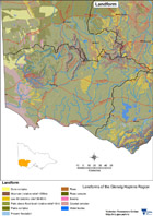
Landform
|
|
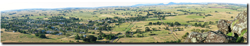
The region is dominated by flat volcanic plains, characteristic of what is known as the Western Districts. These plains comprise the southern two-thirds of the region. The north is dominated by the Grampians, the Dundas and Merino Tablelands and the West Victorian Uplands. The uplands include sedimentary rises which are the western extremity of the Great Dividing Range (Rees, 2000).
There are undulating limestone areas to the region’s west, northwest and north-east of Portland. Undulating sandy deposits occur to the north of Dartmoor below the level of the Tablelands. The lower sandy plains with ridges, are of fairly recent origin and are linked to the retreat of a higher sea from the Murray River Basin, between 2 and 6 million years ago. There are a number of occurrences of coastal plains to the east and west of Warrnambool.
Major streams, such as the Hopkins River and Mt Emu Creek, cut through the basalt rocks creating U-shaped valleys. In contrast, the Tablelands are generally flat to gently undulating, occasionally undulating to rolling hills, dissected in places by deep V-shaped valleys. A range of geological material is exposed such as Cretaceous sandstones, granites of various ages and acid volcanics (rhyolite).
|
This landform map is intended to provide a broad overview of landform types throughout the region. The Land Systems used are described and delineated by Rowan (1989). |
References:
Glenelg Regional Catchment and Land Protection Board (1997). Regional Catchment Strategy. Glenelg CaLPB, Hamilton.
D. Rees (Soil Scientist, Centre for Land Protection Research). pers. comm., December 2000.
Geology Information
Geoscience Victoria's web mapping application allows users to search geospatial databases and display the results as maps or tables. Datasets that can be viewed and interrogated include mineral, petroleum and extractive industries tenements, land-use and airborne geophysical survey boundaries, gravity, magnetic and radiometric images, bore hole & well data, surface geochemistry results, mines and mineral occurrences, and geological maps and interpretations at various scales.
© State of Victoria (Agriculture Victoria) 1996 - 2025.

This work, Victorian Resources Online, is licensed under a Creative Commons Attribution 4.0 licence. You are free to re-use the work under that licence, on the condition that you credit the State of Victoria (Agriculture Victoria) as author, indicate if changes were made and comply with the other licence terms.
The licence does not apply to ‘branding’ or some ‘images or photographs’ that may be owned by third parties. We ask you to seek prior approval to use images using the VRO feedback form. Access to higher quality images can also be provided on request.
This page was last updated on 23/03/2020.