
Land Use
|
Approximately 81% of the Glenelg-Hopkins Catchment Management Region has been developed for agricultural use. About 2% of the catchment area comprises pine forest, while 16% is native forest and less than 1% is used for urban and industrial development (Glenelg CaLPB, 1997). The main agricultural land uses are dominated by dryland pasture (over 2 million ha) and also include horticulture. | 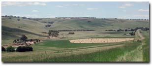 Land use near Coleraine |
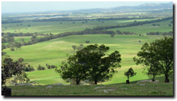 View over the Ararat region | The Portland Coast Basin, which covers just under 400 000 ha of land in the south of Glenelg-Hopkins, is a gently undulating to flat catchment which is mostly cleared for agriculture. Two thirds of the Glenelg River Basin (1.26 million ha in the region’s west) has been cleared for pasture and is still largely wool production with prime lamb also significant. The beef industry is well established but dairy has been steadily declining in recent times. Public land in the region is dominated by National Parks, covering over some 200 000 ha. The Grampians National Park covers most of this area (ie. 167 100 ha). State Parks, Coastal Parks and Reference Areas combine to comprise almost 35 300 ha throughout the region. |
| The Land use map is intended to provide a broad overview of agricultural and other land uses throughout the region. Data used to generate this map was derived from the land use layer (LAND USE250) of the (former) DPI/DSE Corporate Geospatial Data Library. | 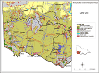 Glenelg-Hopkins Land Use |
© State of Victoria (Agriculture Victoria) 1996 - 2025.

This work, Victorian Resources Online, is licensed under a Creative Commons Attribution 4.0 licence. You are free to re-use the work under that licence, on the condition that you credit the State of Victoria (Agriculture Victoria) as author, indicate if changes were made and comply with the other licence terms.
The licence does not apply to ‘branding’ or some ‘images or photographs’ that may be owned by third parties. We ask you to seek prior approval to use images using the VRO feedback form. Access to higher quality images can also be provided on request.
This page was last updated on 23/03/2020.