
Ararat Hills
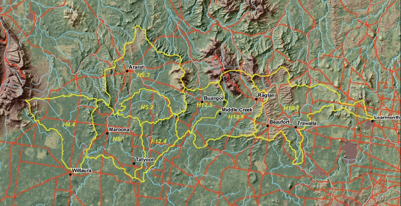
The Ararat Hills Multiple Outcome Project is located in the northeast of the Glenelg-Hopkins CMA (GHCMA) (external link) region. The project is focused on interventions to alleviate threats to high value assets (such as remnant vegetation) in the Ararat hills around Ararat, Trawalla and Maroona. The project area covers approximately 171,000 ha and consists of approximately 5-10% public land and 90-95% private land (with about 500 landowners in hill areas and a further estimated 150 landholders elsewhere). The project is focused on managing land degradation in hill country especially where community assets such as farmland, waterways, biodiversity and cultural values will be protected as a result. The project area includes GHCMA sub-catchments H12.6, H12.5, H12.4, H10.2, H4.4, H5.1, H5.2, H5.3.
Ararat Hills Multiple Outcome Project
Some of the threats being addressed include: damage by rabbits, uncontrolled grazing of grasslands by livestock, soil degradation from dryland salinity and sedimentation of waterways.
Enhancement activities include: landclass fencing to improve management of hill-top grasslands, restoration of habitat using indigenous species and linking habitat with vegetation corridors.
A Brush-tailed Phascogale monitoring program is being used to raise awareness with landholders of the importance of conserving remnant vegetation particularly old trees with hollows. Whole Farm Planning courses and advice are also provided to landholders to help them manage their properties better and implement best practice in natural resource management.
© State of Victoria (Agriculture Victoria) 1996 - 2025.

This work, Victorian Resources Online, is licensed under a Creative Commons Attribution 4.0 licence. You are free to re-use the work under that licence, on the condition that you credit the State of Victoria (Agriculture Victoria) as author, indicate if changes were made and comply with the other licence terms.
The licence does not apply to ‘branding’ or some ‘images or photographs’ that may be owned by third parties. We ask you to seek prior approval to use images using the VRO feedback form. Access to higher quality images can also be provided on request.
This page was last updated on 23/03/2020.