
Hamilton Land System
 |
|
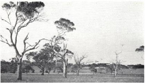 Plate 28 - The Hamilton land-system is typically an undulating basaltic plain with remnants of a formerly extensive woodland of swamp gum. | The western extremity of the extensive volcanic plains of western Victoria covers about 600 square miles in the south-eastern part of the survey area. Of the various flows found there, the earliest and most widespread forms a landscape mapped as the Hamilton land-system. Where this flow, the Hamilton basalt, has been dissected deeply enough to expose underlying materials, the landscape has been mapped as the Branxholme land-system. Frequently, dissection has produced an escarpment and the two land-systems are sharply demarcated, but sometimes, especially in the west, the slopes are long and continuous and the boundary of the land-system less precise.
Physiography The basalt forming the parent material of this land-system is probably late Pliocene in age (Gibbons and Gill 1964) on the basis of evidence mentioned later in this chapter. The surface has been subject to deep kaolinitic weathering which extends to over thirty feet in places. Thickest parts of the flow seem to be just to the north of Tarrington, east of Hamilton, where it has been dissected to a rolling topography. To the west it quickly becomes thinner and there its edge is difficult to determine because the weathering has affected the whole thickness of basalt whilst the underlying material is frequently laterite which is also the product of deep weathering. To the north of Tarrington, it is at the surface for only a short distance and is then covered by a later flow, the Dunkeld basalt. To the south, however, the flow is extensive and forms a relatively flat peneplain surface except where deeply dissected as in the valley of the Condah Swamp and proceeds at least as far as the escarpment from Annya towards Lake Condah and as far as the stony rises from Mt. Eccles. To the south-east it fringes the coastal plains between Bessiebelle and Orford and easterly it continues beyond the survey boundary. |
The deep kaolinitic weathering of the surface of the flow is characteristic of this Hamilton basalt. It strongly resembles a classical laterite profile, and has an upper strongly-reddened and friable zone, an intermediate mottled zone and a lower pallid zone above the altered rock. No indurated horizon characteristic of the top of the typical laterite profile has been found however, and the basalt appears to overlie the lateritised material in a number of places. These facts lead to the belief that the basalt was extruded during a lateritising climate which then persisted long enough to cause the deep weathering. However, the lateritising conditions were either not sufficiently intense or lacked the proper topography to produce the indurated zone at the surface. Hallsworth and Costin (1954) and Gibbons and Gill (1964) think that there were such conditions at the end of the Tertiary, particularly the middle and late Pliocene, and this is supported by the evidence, based on fossils in underlying strata at Grange Burn near Hamilton (Gill 1957), of a late Pliocene age for this particular basalt.
In many parts, the kaolinised surface has been removed by erosion but it is prominent around Tarrington, being characteristic of the Hamilton sub-system, and frequently remains as a capping of variable thickness on rises throughout the Monivae sub-system. Where the road running cast-west through Knebsworth forms cuttings in the escarpments of the valley of the Condah Swamp, there are good examples, not only of the various zones of the kaolinised surface and their relationship to the underlying fresh basalt, but also of the fundamental pattern of soils on the slightly-dissected Hamilton landscape.
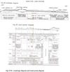
Soils
The fundamental pattern. is shown in the land-system diagram (Fig. 36).
On the kaolinitic zone soils are either transitional krasnozems (Hamilton series) or more frequently red solodic soils (Monivae series) or their intermediates. The former series closely resembles the Sherburn series of the Portland area but because the parent material is bauxite it has no freshly weathering basalt boulders in the profile as has the Sherburn series. The red solodic soils have a sharp texture contrast in the upper horizons and soils intermediate between them and the transitional krasnozems are common. They form on a slightly lower catenary position from the transitional krasnozems, and are essentially intermediate in position and character between the transitional krasnozem and the widespread Normanby family of solodic soils, mentioned below. Soils of the Monivae series, therefore, are common where the surface of the kaolinised zone is undulating, the transitional krasnozems being restricted to the tops of the more sharply dissected parts of the kaolinised zone. In both series, the subsoil usually has a high content of clay which is not friable. The series are most common in the Hamilton sub-system.
Middle and lower slopes which are usually beneath the level of bauxitic weathering and form the greater part of the gently-dissected Hamilton landscape, support brown solodic soils. These are usually gilgaied and chiefly of the Normanby family with structure and consistency which are unusually good for the surface horizons of a solodic soil. Irregularly-shaped kaolinitic nodules are found throughout the profile but are fewer and smaller in positions furthest away from the bauxitic residuals, whilst nodules of buckshot become increasingly frequent in the A, horizons, in lower sites. Unusually deep A horizons are sometimes encountered and, like the A horizon of soils on all the areas covered by the Normanby family, may be composed in part of material blown out of cinder cones and deposited over the landscape; Leeper, Nicholls and Wadham (1936) postulate such an origin for the A horizon of similar soils near Winchelsea in western Victoria. The Normanby family is most common in the Monivae sub-system.
Limited areas of prairie soil and occasionally chernozems are in lower topographic positions, and in the wettest sites, along drainage lines and in swamps, particularly in the Hamilton sub-system, these merge into peats. Large areas of peat have been mapped separately as the Condah Swamp land-system; examples are Buckley's Swamp south-east of Hamilton and the flats south of MacArthur.
The kaolinitic zone has a lower content of bases than has the fresh basalt consequently on the plateau surface in the wetter and colder parts of the Greenhills land-unit, where there is little opportunity for the accumulation of bases, solods have been formed in place of solodic soils.
In general, the nutrient status of the soils of the land-system is moderately good, especially towards the lower sites, where they are influenced by freshly-weathering basalt. Although the Normanby family is better than other solodic soils, phosphate is in low supply.
Vegetation
Most of the land-system, except the Bochara land-unit, where red gums remain, gives the impression of having been either treeless or very sparsely timbered originally; even the stock routes usually have but little timber. There are, however, a few odd paddocks which have not been cleared, and old records show that the greater part of the land-system, particularly the Greenhills land-unit, was originally a tall woodland or dry sclerophyll forest of swamp gum (Eucalyptus ovata) with some lightwood (Acacia implexa), she-oak (Casuarina stricta) wild cherry and honeysuckle. In other parts such as Monivae and Hamilton land-units, the density of timber seems to have been less, forming a savannah woodland. This was especially so on heavier soils in lower sites where the gums were sparsely distributed with intervening areas of native grassland, and doubtless encouraged the early settlement around Hamilton. There was probably a sparse cover of swamp gum and red gum in the Ardachy land-unit with native grasses abundant. Small stands of red gum which remain in this land-unit near Branxholme are the most southerly occurrence of red gum in the survey area except for some stands near Dartmoor. Blackwood, rather than lightwood, is recorded for the Hamilton land-unit, but neither of these closely-related acacias are seen now in the district.
Small local areas of scattered sandy country carried a dry sclerophyll forest of swamp gum and stringybark, much of it remaining uncleared because of the poverty of the soils. Characteristically, however, apart from the north-western parts, this land-system carried tall woodlands or forests of swamp gum with a scattering of Acacia and Casuarina, and these stands have now virtually disappeared.
It is useful to consider the reason for this almost wholesale disappearance of an originally quite dense cover of timber, in contrast with the preservation of much of the red gum woodlands of the lateritised tablelands.
Swamp gum is not a useful timber and therefore on land of good grazing potential it was ringbarked and burnt indiscriminately, and regeneration was not encouraged. Apart from the grazing of stock, probably the chief reason for its disappearance is the difficulty of natural regeneration under the local conditions. A general consideration of the ecological niches occupied by the various eucalypts in south-western Victoria suggests that the typical soils of the Hamilton land-system the red solodic soils and the Normanby family - are not ideal for swamp gum which tolerates wet conditions in winter very well but cannot withstand dry summer conditions unless on deeper friable soil which encourages its otherwise shallow rooting system and allows it to penetrate a zone of greater soil moisture capacity. The former widespread distribution of swamp gum over the, Hamilton land-system is probably less an indication that it is well suited to the conditions there than that it existed in the absence of severe competition from other species. Red gum and yellow gum are restricted to less exposed and possibly somewhat drier areas, and messmate requires more friable sub-soils and higher rainfall. Stringybark is undoubtedly excluded by the heavy subsoil, whilst manna gum which otherwise might survive in the landscape, probably was prevented from growing in the community by surface water-logging during the winter. Therefore, although swamp gum was dominant over the Hamilton land-system, its existence was precarious and it did not regenerate strongly in the exposed conditions after widespread clearing.
Land-use
The removal of the timber left a pasture of native grasses growing under somewhat exposed conditions very suitable for Merino wool production, which became the dominant land-use. Big grazing stations were established, mainly by Scottish settlers, particularly in the Ardachy, Monivae and the northwestern parts of the Greenhills land-units, where the timber was originally less dense ; many of these stations have remained until quite recently. In the Hamilton land-unit, the diversity and nature of the soils were more suitable for a range of agriculture and under the stimulation of the Hamilton market, a community of German settlers around Tarrington developed some cereal growing, fat-lamb production and dairying. Near Hamilton itself, there was market gardening in the lower parts of the landscape on the dark peaty clays.
Whilst the pattern of soils elsewhere in the land-system is not so diverse nor so favourable for intensive farming as in the Hamilton land-unit, there is little doubt that more intensive and diverse forms of land-use are possible over the land-system in general. In northerly parts, especially in the Bochara land-unit, late annual improved pastures can be developed easily to support cross-bred wool growing with fat lambs and beef cattle raising. Elsewhere, as in the Ardachy, Monivae and northern parts of the Greenhills land-units, similar enterprises can be based on late annual and perennial improved pastures and carrying capacities can be high with fodder crops and fodder conservation. This has been shown by individual farmers and also by the findings from the Hamilton Pastoral Research Station at Monivae. Information from there applies particularly to these latter areas, as the pattern of soils on the Research Station (Newell 1962) is typical of the range encountered in the Ardachy, Monivae and the northern parts of Greenhills land-units. The southern parts of the Greenhills land-unit are wetter, the average annual rainfall being about 31 inches, and perennial pastures can be grown. These permit dairying, fat-lamb raising and beef cattle grazing. As virtually all of the land-system has already been taken up, there is no scope for land settlement schemes except by division of the big estates, and this has been done by the Soldier Settlement Commission in various projects.
Erosion
Soil erosion is not severe over the land-system as a whole; the hazard is low because of the generally slight relief. Over most parts where the topography is undulating, there has been sheet erosion caused by runoff following the widespread sealing and loss of structure of the surface soils. Gullying, however, is rare within the land-system, as those parts of the landscape where the slopes are steep and long enough for deep gullying have usually been separated out as the Branxholme land-system. In a few areas, particularly in Ardachy land-unit, drains leading from swamps on the plateau surface have scoured out to form gullies. In those areas pasture improvement, because it reduces surface scaling and restores soil structure, may stop sheet erosion, and also reduce the runoff to be carried by drainage lines of the adjacent Branxholme land-system. In the Hamilton land-unit, the topography is steeper and there is some gullying especially along roadsides.
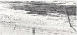 Plate 29 - The Hamilton basalt has been dissected in parts to depths of up to two hundred feet to form the Branxholme land-system. (Here, one such valley is seen, and down it have flowed the recent lavas from Mount Napier in the distance.) | Summary One of the earliest of the basaltic flows which have given rise to the volcanic plains of western Victoria has been deeply weathered at the surface and moderately dissected in parts. Those areas where any dissection has not been deep enough to expose underlying rocks have been mapped as the Hamilton land-system. The chief soils are solodic soils of the Normanby family, with lesser areas of transitional krasnozems and red solodic soils on the remnants of weathered basalt, and prairie soils and peats in the lower positions. Tall woodlands, mainly of swamp gum, once covered most of the land-system, but these were destroyed and replaced by grasslands of native grasses which supported Merino wool growing. The moderate fertility of the soils allows high carrying capacities of sheep and cattle to be attained, based on late annual and perennial improved pastures, fodder cropping and fodder conservation. |
© State of Victoria (Agriculture Victoria) 1996 - 2025.

This work, Victorian Resources Online, is licensed under a Creative Commons Attribution 4.0 licence. You are free to re-use the work under that licence, on the condition that you credit the State of Victoria (Agriculture Victoria) as author, indicate if changes were made and comply with the other licence terms.
The licence does not apply to ‘branding’ or some ‘images or photographs’ that may be owned by third parties. We ask you to seek prior approval to use images using the VRO feedback form. Access to higher quality images can also be provided on request.
This page was last updated on 23/03/2020.