
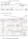
Glenelg Land System
 |
|
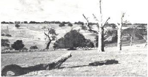 Plate 21 - The Glenelg land-system is the sloping and dissected country beneath the level of the Dundas tablelands, and where most of the soils are sandy at the surface and carry red gum or manna gum. | When a landscape with a surface crust harder than the underlying material is eroded, the sides of the erosion channel are steep. On the Dundas Tablelands, the surface layers are of laterite which becomes hard when exposed, whilst underlying rocks are usually softer. Dissection of this plateau frequently results in steepsided valleys, and where the underlying rocks are particularly soft, especially in the lower reaches of the streams, these valleys may be deep and spectacular. Such valleys carved out of the Dundas Tablelands belong to two land-systems, depending on the rocks exposed. Where the rocks are chiefly Mesozoic sediments, the Casterton land-system is formed, and where other rocks predominate, the Glenelg land-system results.
Distribution The bulk of the Glenelg land-system fringes and ramifies with the main mass of the Dundas land-system, which, as described in the previous Chapter, lies towards the centre of the huge circle enclosed by the Glenelg and Wannon Rivers. A group of smaller areas is adjacent to the tableland remnants which fringe the Kanawinka fault, as around Dergholm, Casterton and Digby, and is separated from the main areas by the Casterton land-system. |
Climate
Average annual rainfall varies from about 24 to 30 inches, the wettest parts being those which fringe the Brim Brim plateau and those that lie around Digby. These are separated as the Wando and Digby land-units respectively. Temperatures, both seasonal and diurnal, are more extreme than those for the coastal areas. The length of the growing season, away from low topographic sites, varies from about five months at Balmoral to about eight months in the Wando, and Digby land-units.
Parent Materials
A variety of parent materials is exposed, but they are chiefly Tertiary sediments, acidic igneous rocks and glacial deposits of Permo-Carboniferous age, with small areas of Mesozoic sediments. The Tertiary sediments are exposed mainly in the western and south-western parts of the land-system, that is, the Dergholm, Bahgallah and Digby land-units where they overlie Mesozoic sediments. Older rocks are more common in the land-units which lie to the north-east of the Casterton land-system.
Physiography
(i) Basis of physiographic subdivision of land-system. - The depth of dissection may be as much as 500 feet, but the heads of the valleys may be quite shallow. Deep or shallow however, they are nearly always separated from the plateau by an escarpment, the exception being when there are particularly hard rocks immediately underneath the laterite, as in some parts of the Wando land-unit. Depth of dissection is one of the criteria used for separating different land-units. Thus, the Stapylton land-unit comprises the relatively shallow head-valleys less than about 100 feet deep, the Chetwynd land-unit includes some of the downstream sections where valleys may be 300 feet deep, whilst the Dergholm, Digby, Baligallah and Wando land-units are dissected to greater depths.
As the land-system is dissected by numerous streams, a useful approach to understanding it is as a number of entities each associated with a particular stream.
The streams and their catchments can be considered in two groups. The main group, the catchments of which together comprise the Stapyhon sub-system, radiate from the uplifted and back-tilted Brim Brim plateau; they may be further divided into those draining the tilted plateau surface, those flanking the plateau and those draining the bluff along the south-western edge of the plateau. A second group, with catchments constituting the Dergholm sub-system, deeply dissect the western edge of the lateritised Dundas Tablelands fringing the Kanawinka and associated faults. A brief description of these catchments follows, on the basis of the sub-systems and in terms of the various land-units, which are usually whole catchments or a logical topographic subdivision of them.
(ii) Catchments of the Stapylton sub-system.
(1) Catchments draining the tilted plateau surface.
Pigeon Ponds Creek is a long stream with an extensive catchment area. Both major and minor creeks of this basin are strongly orientated along the lines of the two chief regional directions of faulting-mainly north-north-westerly but also north-easterly. The reason, doubtless, is that early drainage of the plateau collected along lines of minor crustal disturbance - warping or faulting - and became entrenched along them, particularly where they wore also lines of crustal weakness. As dissection became deeper, the degree to which the direction of faulting controlled the drainage system became less. So, in the more deeply dissected parts of the basin, the orientation is weaker on the local scale although still pronounced on the regional scale. This situation applies generally in the land-system, the shallowly-dissected Stapylton land-unit nearly everywhere being strongly orientated, whilst the land-units which are more deeply dissected, are less orientated.
In the upper reaches of the Pigeon Ponds Creek basin, dissection of the tableland has formed characteristic sharply-defined shallow drainage lines generally about one quarter to three-quarters of a mile wide. Although they are numerous, forming about 50 per cent of the area, these shallow drainage lines are yet sufficiently distinct, and the tableland areas sufficiently contiguous, for both tableland and dissected parts to be delineated separately. On this basis, the upper reaches of Pigeon Ponds Creek, together with the upper reaches of Schofield's, Mostyn, Mather's and Glendinning Creeks and the Dundas River, have been mapped as the Stapylton land-unit, whilst the adjacent tablelands have been mapped as the Dundas land-system.
On the lower reaches dissection is moderately deep, although there are never any extensive areas where dissection is consistently below the tableland level as in the Wando land-unit or the Casterton land-system. Escarpments to the tableland are common and characteristic therefore, and this feature is important as a cause of hillside seepage salting. This lower tract of the stream is very similar to the corresponding parts of the Chetwynd basin and the lower reaches of the adjacent Muryrtym, Schofield's and Mostyn Creeks described below. They have all been mapped as the Chetwynd land-unit as it was here that the landscape was described in eulogistic terms by Major Mitchell's lieutenant, Chetwynd Stapylton.
A series of small creeks cuts back a short distance from the Glenelg River which flows westerly along the northern edge of the plateau. The chief of these are the Muryrtym, Schofield's and Mostyn Creeks. For most of their course they dissect the tablelands moderately deeply, because the nearby Glenelg River, from which they are cutting back, is deeply entrenched. Convex-shouldered hills and escarpments to the tablelands are common, therefore, and these tracts have been mapped as the Chetwynd land-unit, together with similar country in adjacent catchments. Salting often occurs on the steep shoulders at some distance below the crest. For short distances in their upper reaches, the drainage lines are shallow and narrow and have been mapped as the Stapylton land-unit.
Mather's Creek, flowing generally to the north-east from the central block of the Dundas land-system, has the most extensive single catchment area, draining the greater part of the Brim Brim Plateau. In its upper reaches, it is identical with the upper parts of the Pigeon Ponds Creek, forming the same pattern of north-easterly and north-north-westerly trending drainage lines and has been mapped as the Stapyhon land-unit. Lower reaches are more deeply dissected and have been mapped as the Chetwynd land-unit which they most closely resemble, although dissection is not so deep as in other parts of that land-unit.
East of the Balmoral-Cavendish railway line, the series of generally northerly-flowing streams is continued in the Englefield and Glendinning Creeks. These, of moderate size, are otherwise similar to the rest of the series in general physiographic character, and comprise both the Stapylton land-unit upstream and the Chetwynd land-unit downstream. However, the climate is drier, there are marked changes in the species of vegetation and there is a greater tendency to salting.
(2) Catchments flanking the plateau.
Dundas River is the easternmost of these streams. Its catchment is a shallow drainage system fed by the areas east of the Dundas Range and has been mapped as part of the Stapylton land-unit. Skeleton Creek is a major tributary of the Dundas River, whilst the Mooralla and Redruth Creeks are similar, all flowing into the Wannon. Shallow escarpments fringing wide valley floors are characteristic.
Immediately to the south-east of the plateau, the catchments of the Koroite River and Konongwootong Creek form a major basin. This is moderately deeply dissected except for its headwaters and taps the country between the Dundas Range and the plateau. Shallow, ramifying headwaters on the north-east of the catchment have been mapped as the Stapylton land-unit, because they are similar to other areas of that land-unit, but the main bulk of its central reaches, where granite outcrops are common, has been termed the Konongwootong land-unit from the parish of that name. The lower reaches, south of Gritjurk and the western branches of the whole of the Konongwootong Creek expose Wsozoic sediments, and the valley there is part of the Casterton land-system.
On the other flank of the Brim Brim Plateau, to the north-west, is the Chetwynd River with its chief tributary, the Cairns Creek. These streams drain a moderatelysized catchment with upper reaches consisting of tablelands predominantly dissected to a moderate depth. Tableland residuals are present throughout, but are too small and scattered to be mapped separately at the scale of survey. The whole complex in the upper reaches therefore, has been mapped as another land-unit, the Mitchell land-unit, so named because it was to these parts that Major Mitchell applied his famous epithet "Australia Felix". In the lower reaches, dissection is deeper, to about 300 feet and valley walls are steeply shouldered; like the lower parts of the adjacent easterly tributaries of the Glenelg, such areas have been mapped as the Chetwynd land-unit except around the township of Chetwynd itself where Mesozoic sediments are exposed.
The catchment of the Steep Bank Rivulet adjoins that of the Chetwynd River. In its upper two-thirds, it is of tableland country predominantly dissected to a moderate depth with scattered residual tablelands. It resembles similar tracts of the Chetwynd River basin and has been mapped as the Mitchell land-unit except near Warrock where it resembles and has been mapped as the Wando land-unit. Mesozoic sediments give rise to the Casterton land-system in the lower reaches.
(3) Catchments draining the bluff.
Den Hills Creek and Wennicott Creek flow south into the Wannon and Koroite Rivers respectively, near the junction of the latter. In the central and lower portions of their catchments, Mesozoic rocks are exposed and so only the upper portion is part of the Glenelg land-system. However, it is still deeply entrenched without shallow, ramifying headwaters, because the creeks are draining the bluff of the elevated Brim Brim Plateau which has caused a rejuvenation of the streams on its uplifted perimeter. Some harder rocks underlie the laterite and the junction of the basin and tableland takes the form of broadly rolling and sweeping slopes which have been mapped as the Wando land-unit.
The basin of the Wando Vale Ponds Creek and its tributaries is also deeply entrenched, and like that of the Trangmar and Wennicott Creeks has virtually no intermingling with tableland areas. Thus, at the heads of the catchment, the topography is one of broadly rolling slopes sweeping away from the tablelands. This is in contrast not only with most other land-units of the Glenelg land-system where escarpmented valleys intermingle with the tablelands, but also with the Casterton land-system which has a rolling and hilly topography that culminates only infrequently in tablelands, but then always abruptly, with an escarpment.
Upper parts of this basin are mapped as the Wando land-unit whilst the lower reaches, because Mesozoic sediments are exposed there, are in the Casterton land-system. An erosion survey of this catchment by Forbes and Leslie (1950) pinpointed the source of most of the sand covering the lower reaches of this creek and the adjacent Wando River, as the granitic soils of the Wando land-unit.
The catchment of the Wando River is similar to that of the Wando Vale Ponds Creek, except, that the head of the chief stream has enflanked the main south-westerly bluff of the back-tilted Brim Brim Plateau and has breached it laterally from the north-west. It has thus captured an extensive system of shallow drainage lines on the tableland itself. In some places, the entrenchment of the drainage lines is just sufficiently deep for them to be separated out like the similar drainage lines at the head of the Pigeon Ponds Creek and Mather's Creek and to be mapped as the Stapylton land-unit. Nevertheless, because the pattern is intricate, and because the vegetation and climate of the area as a whole are different from those of other areas, they are mapped together with the adjacent areas of tableland as a pattern within the Dundas land-system, namely, the Brim Brim land-unit. Middle reaches of the catchment have been mapped as the Wando land-unit and the lower reaches, below Wando Station, as the Casterton land-system because Mesozoic sediments are exposed. An erosion survey of this catchment by Mitchell (1958) showed that most of the siltation material above the junction with the Wando Vale Ponds Creek was from within the Casterton land-system and not the Glenelg land-system.
(iii) Catchments of the Dergholm sub-system. - Stokes River with0Humpy's Creek flows west-south-westerly along the line of regional fall and joins the Glenelg on the coastal plains. In doing so, it breaks through the western escarpment of the lateritic tableland and leaves the area, of the tableland altogether. It exposes rocks which have been mapped by Kenley (1955) as the Merino Group of Mesozoic sediments, but sandy deposits, possibly early Tertiary, are at the tops of the slopes and have imposed podsolic features on the soils at lower catenary positions. The catchment has long slopes of varying steepness, but beneath the escarpment these slopes do not have much change of grade, and extend to a fairly narrow drainage line, thus forming a wide, V-shaped valley. There are no ramifying headwaters like those found in the Stapylton land-unit and the whole catchment has been mapped as the Digby land-unit.
Dwyer's Creek is dissecting back into the western edge of the laterite, not from the coastal plains, but from the Wannon River which is deeply entrenched to the east within the area of tablelands. The headwaters, which bear no resemblance to the shallow valleys of the Stapylton land-unit, have almost, but not quite, reached the western edge of the laterite at the Killara fault-line. Apart from the lower areas where the Mesozoic sediments are exposed, topography, vegetation and soils of the Dwyer's Creek catchments are similar to those of the Stokes River Catchment and the area has been mapped as the Digby land-unit.
The Glenelg River itself breached the western edge of the laterite at an early stage and has become deeply entrenched in it south, west and north of Casterton, exposing early Tertiary sediments overlying Mesozoic sediments. Valley sides are escarpmented at the summit, steeply sloping throughout and prone to landslips. Those adjacent to the river and those where the soils have been influenced by the sandy sediments, have been mapped0as the Bahgallah land-unit. This deep dissection of the tableland by the Glenelg continues further north to near Dergholm. The main valley is very narrow with steep sides, but occasional side-valleys are dissected south-westerly and a shallow valley, the Salt Creek, extends north-north-westerly to expose granite. North of Casterton, dissection by the Glenelg is shallower than in the Bahgallah land-unit, but deeper than in the Chetwynd land-unit into which the valley merges upstream; consequently the valley has been separated as the Dergholm land-unit.
(iv) Summary of physiography. - In brief, the catchments of the Glenelg land-system can be considered in two sub-systems. The larger one, Stapylton sub-system, is associated with a series of streams radiating from the central uplifted and back-tilted Brim Brim Plateau. Of these streams, those draining the tilted plateau are typically shallow, escarpmented and strongly orientated in their upper reaches; they become more steeply entrenched near the main waterway, the two tracts being mapped respectively as the Stapylton and Chetwynd land-units. Those streams flanking the block have catchments which are moderately deeply dissected, e.g., the Mitchell and Konongwootong land-units. Those draining the bluff along the south-western perimeter of the plateau are deeply entrenched, not strongly orientated, and in their lower reaches expose Mesozoic sediments; upstream from these sediments they are mapped as the Wando land-unit. The second group of catchments, the Dergholm sub-system deeply dissects the western edge of the lateritised tablelands and has long steep slopes to one main stream, exposing Early Tertiary sediments overlying Mesozoic sediments. The hazard and manifestation of erosion are closely related to the land-units and catchments.
Soils
Characteristic soils of this land-system are solodic soils and those intermediate between solodic soils and leptopodsols. These are soils of Orders V and IV respectively, in contrast to those of the physiographically-related Casterton land-system where Mesozoic sediments have produced soils of Order VII, chiefly prairie soils.
Parent material, topographic position and to a lesser extent the rainfall determine the more precise nature of the soils within the land-system. With most of the parent materials encountered in the situations with higher rainfall, and in upper topographic positions the soils tend to be without sharp textural boundaries, that is, they have the podsolic rather than the solodic texture profile. Consequently, most of the Digby land-unit and the crests of hills elsewhere in the land-system often show these intermediate soils. This may not always be so, however, as shown by the mapped distribution (Blackburn and Leslie 1958) of the Konongwootong series (a coarse sandy brown earth) and the Hassall series (a solodic soil) on granite. Elsewhere, however, solodic soils are dominant.
Parent material probably has the greatest effect on the soils, and Blackburn and Leslie (ibid) have shown how the six series which they mapped within this landsystem in the parishes of Konongwootong and Coleraine are closely linked with the rock type. Thus, the Hilgay series of solodic soils is restricted to Tertiary sediments in the parish of Coleraine, the Bryant series of solodic soils to Permian deposits, most likely, and the Konongwootong and Hassall series to granite. No other detailed surveys of the soils of this land-system have been made, but it is likely that the chief soils of most land-units in the land-system include one or more of the series grouped as "variable sandy soils below tableland level" described by Blackburn and Leslie (ibid).
Soils of lesser importance are usually associated with parent materials of limited distribution and whilst such parent materials are sometimes distributed at random within the overall pattern of the land-system, they are more often restricted to particular topographic situations or associated with a particular rock-type. In this way, the land-units with Tertiary sediments as a common rock, such as Dergholm, Bahgallah and Digby, have localised areas of sand blown therefrom and this sand gives rise to nomopodsols-iron-nornopodsols in the Dergholm land-unit and both iron nomopodsols and humusnomopodsols in others with higher rainfalls. Also, lateritic material on escarpments or tops of hills which do not quite reach to tableland level usually produces a red solodic soil or clay leptopodsol. These latter soils, although they constitute a minor proportion of the whole, are distributed over appreciable areas in parts where there is shallow or narrow dissection as in the Stapyhon and Chetwynd land-units respectively. Alluvial soils and meadow soils are found also on flat valley floors.
Vegetation
The Glenelg land-system was wooded originally over most parts, eucalypts were lightly scattered, but on the drier sites there were she-oaks and wattles which were dense where the soil was rocky or lightly scattered where it was sandy. However, it is difficult to interpret the old records and parish plans accurately because of the intimate complex of radically different soils found on the borders of the Casterton and Glenelg land-systems. Also, the clearing for fuel of timber adjacent to naturally treeless areas may have changed the condition of the timber soon after settlement. In spite of this, what was said at the beginning of this paragraph probably applied to land-units with less than 29 inches average annual rainfall. In land-units with higher rainfall, such as the Wando and Digby, the original vegetation was almost certainly more dense than elsewhere and even now this is so in parts. This conclusion is supported by the marked infestation by bracken over these two land-units. Such a growth of bracken is most unusual on naturally treeless or sparsely timbered land in Victoria, but is common on land which was originally densely timbered.
Where the average annual rainfall is less than 29 inches, red gum (Eucalyptus camaldulensis) is the chief tree, with some manna gum (E. viminalis).
In the Wando land-unit, manna gum and swamp gum (E. ovata) are prominent and red gum less so, whilst in the Digby land-unit red gum is absent altogether, and snow gum (E. pauciflora) is present with the manna and swamp gum.
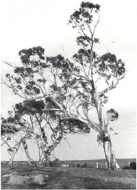 Plate 22 - Snow gum (Eucalyptus pauciflora) is found in isolated and scattered patches in south-western Victoria.(Most are where the rainfall exceeds 30 inches and on exposed sites, such as this at the crest of slopes in the Digby land-unit.) Plate 22 - Snow gum (Eucalyptus pauciflora) is found in isolated and scattered patches in south-western Victoria.(Most are where the rainfall exceeds 30 inches and on exposed sites, such as this at the crest of slopes in the Digby land-unit.) | This sequence of vegetation resembles that found in the Dundas land-system. Robertson (1853) mentions blackwoods (Acacia melanoxylon) as once profuse, but then killed off. Those land-units in which the rocks exposed are chiefly Tertiary sediments, that is Dergholm, Bahgallah and Digby, have scrubs of stringybark or manna gum or both, on the minor soils, the nomopodsols. The dense growth of she-oak, and Acacia spp., on lateritic escarpments, may have had an effect on the usage of water seeping out at the base of the laterite. The presence of such a dense growth probably prevented the type of hydrologic problem which resulted later after clearing. Land-use The history of the type of land-use in the Glenelg land-system is much the same as over the Dundas land-system in broad outline. There is the same sequence of early settlement, almost a century of thinning out of the red gum and of grazing of Merino sheep, and in the last twenty years a gradual change to improved pastures followed by a moderate swing to medium-woolled sheep and a slight swing to meat breeds. The increase in meadow hay, grain oats and beef as disclosed by the statistics for the County of Dundas almost certainly applies to the Glenelg land-system as well as to the Dundas land-system.
|
Erosion
By contrast with the Dundas, however, the Glenelg land-system has a considerable erosion hazard.
The free regional drainage leads often to dry conditions and bare pastures in the late summer and much of the land is steeply sloping, so that conditions have prevailed for sheet, rill, gully and stream-bank erosion, and these forms of erosion are widespread over most of the land-system. Sheet erosion, particularly, was widespread until about ten years ago, but its incidence diminishes as improved pastures extend and now it is encountered over only about forty per cent. of its former extent. For gullying and stream-bank erosion, however, the most severely affected areas are in the catchments where dissection is deep or at least steep, and where rocks producing coarse sand are exposed, that is granite and to a lesser extent Tertiary sediments. These conditions are fulfilled in the Konongwootong land-unit, parts of the Wando land-unit, especially the Wando Vale Ponds Creek catchment which flows through both granite and Tertiary sands, in the Pigeon Ponds Creek catchment and in the Digby and Dergholtn land-units. In the Chetwynd land-unit also, along the lower tracts of the Chetwynd River and Muryrtym, Schofield's and Mostyn Creeks, many of the heads of creek-lines are actively gullying and there is some instability at the head of tributaries of Mather's Creek.
One of the consequences of the gullying and stream-bank erosion of those areas is the severe siltation of parts of the lower reaches of the same streams. This has happened particularly in the Wando Vale Ponds Creek, Wando River, Koroite Creek and the Glenelg River itself, although gully erosion in the adjoining Casterton land-system has contributed siltation material in some places. Details are given in an early report by Forbes and Leshe (1950) for the Wando Vale Ponds Creek and later by Mitchell (1958) for that Creek and the Wando River.
Deterioration following changes in Hydrology
Also in this land-system are examples of deterioration induced by upsets in the hydrological balance on both the edge of the tablelands and in the valleys themselves. The top layers of the tableland are laterite with bases of kaolinised rock; seepage frequently occurs at the level of the base of the laterite, from which it is inferred that this kaolinised zone, at those points, is more permeable than the material beneath it, and this relationship may be general. It may be presumed that since replacement of the perennial tree cover by sparse annual pastures, such seepage has been initiated or increased. This is because the replacement would have resulted in less water being used by evapo-transpiration, and hence in a greater penetration of water to the deeper subsoil and below, as well as in a more prolonged saturation of the A, horizon of the predominantly solodic soils.
This seepage from the base of the laterite has had two effects in the dissected areas - it has caused lubrication of the subsoils on steep slopes and started mass movement as earth flows or slumping, and it has brought soluble salts to the seepage area, to cause salting. Each of these two effects however is more prominent in one land-system than in the other. The reason for this is that the nature of the soil which is conducive to mass movement by lubrication is not conducive to salting, and soil features conducive to salting are not those favouring mass movement. Thus, in the Casterton land-system, the common soils are prairie soils and chernozems. These have permeable subsoils with high contents of exchangeable sodium, silt and fine sand, and such features aid the lubrication of large structural units ; their surface horizons have a high exchange capacity dominated by calcium and are therefore resistant to domination by sodium salts. Consequently, in the Casterton land-system, seepage along the base of the laterite has resulted in mass movements of the type requiring lubrication-slumping, earth flows and solifluction - but not salting. By contrast, in the Glenelg land-system, the common soils are solodic soils. In these, the subsoils have lower permeability and massive structure and are not easily lubricated, but the surface soils have a low exchange capacity and are easily dominated by sodium. In the Glenelg land-system therefore, seepage along the base of the laterite has resulted in hillside seepage salting. Only rarely has it resulted in mass movement and then only in those land-units where Mesozoic sediments occur somewhere on the slopes-namely, in the Dergholm sub-system.
Salting has certain climatic requirements, and these are most prevalent in the north-east of the County of Dundas, so that, with a few exceptions, hillside seepage salting in the Glenelg land-system is virtually restricted to the escarpment of the Chetwynd land-unit near its junction with the Dundas land-system and to the north-eastern areas of the Stapylton land-unit. Where it does occur, however, it forms a prominent line of sheet-eroded dark patches somewhat below tableland level and conspicuous on the aerial photographs (plate 23).
In the valleys, the lowering of the rate of evapo-transpiration as a result of cutting down trees has similarly resulted in greater amounts of water in the soil after the wet period. Because of the characteristic restriction of vertical drainage in the solodic soils, the A horizon is saturated for a longer period than before clearyng. This has resulted in increased sub-surface flow laterally through the A horizon, and this lateral flow has carried quantities of salt to the topsoils of the lower topographic positions and has induced catchment salting. Again, because of the climate, salting in the valley bottoms of the Glenelg land-system is generally restricted to the Cavendish-Balmoral area.
If the valleys extend to only just beneath the base of the laterite, then catchment salting and hillside seepage salting augment one another. It may be expected therefore that where there are shallow concave valleys in the drier parts of the Glenelg land-system with predominantly solodic soils, that there will be such augmentation, and salting will be most severe. These conditions are met in the Stapylton land-unit of the Dundas River, Skeleton Creek and Mooralla Creek areas around Cavendish, and there, nearly every drainage line is severely salted. The Stapyllon land-unit is the most badly-salted part of the survey area, and. continues north-eastwards into the Glendinning area of the adjacent Grampians survey area (Sibley in preparation). This situation resembles the severe salting of the shallowlydissected lateritic landscapes in Western Australia. The chief difference is that the more seasonal nature of the rainfall in those parts of Western Australia makes curative measures more difficult because after clearing, contrary to the situation in Victoria, shallow-rooted perennials cannot persist into the dry period and thus increase evapo-transpiration. Around Cavendish, salting is probably the chief cause of the severe sheet erosion and shallow gullying which is associated with it. The remedial measures for both the short-term re-establishment and long-term rehabilitation of salted areas apply here also.
The Individual Land-Units
Stapylton land-unit is restricted to the comparatively shallow valleys at the head of s me streams., particularly those draining large areas of tableland with only a slight grade; it encloses areas where dissection has not exceeded about 100 feet. Solodic soils end savannah woodlands of red gum predominate, with some alluvial soils. There are shallow gullies and salting throughout the entire land-unit and some severe salting around Cavendish.
Chetwynd land-unit includes areas of deeper dissection, up to 300 feet, and is often encountered in the lower reaches of those streams the upper parts of which constitute the Stapylton land-unit. There are prominent round-shouldered escarpments along the junction of this land-unit with the Dundas land-system, and hillside seepage salting is common along these escarpments at the base of the laterite. Solodic soils, alluvial soils and savannah woodlands of red gum are characteristic. Sheet erosion, rilling and gullying are features of the minor creek lines, with stream-bank erosion and some siltation in the major streams.
Mitchell land-unit is an intimate complex of moderately-deeply dissected country such as the Chetwynd or Wando land-units, and small plateau remnants, Solodic soils again predominate and support savannah woodlands of red gum, whilst there are a few local sandy areas supporting bracken. The various forms of water erosion are common but usually not severe.
An area of moderately-deeply dissected country containing much granite, in the Koroite Creek catchment, has been mapped as the Konongwootong land-unit (plate 21) and supports sandy soils, some of them solodic soils such as the Hassall series and others brown earths like the Konongwootong series. Moderate slopes and red gum in savannah woodlands are characteristic.
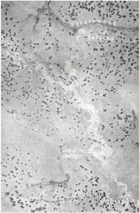 Plate 23 - The abrupt escarpment separating the Dundas and Glenelg land-systems is marked on this photo by the darker-coloured lines in brackets, the beginning of minor drainage lines, and differences in evenness of colour. (Salting can be seen along the base of the escarpment, sand deltas and the siltation, salting and gullying of the main drainage lines. [Photo: Vic. Lands Dept]) | The Dergholm, Bahgallah, Digby and Wando land-units are all deeply dissected to about 400 or 500 feet. The first three of these constitute the Dergholm sub-system and expose Tertiary sediments overlying Merino Group Mesozoic sediments, and the last-named, Wando, contains Tertiary sediments, granite and metamorphic rocks. This Wando land-unit usually has a rather diffuse separation from the Dundas tablelands with broad, convex slopes sweeping away from the plateau, whilst the land-units of the Dergholm sub-system tend to be sharply defined from the tablelands by an escarpment, and have long, moderately steep to steep slopes extending down to a narrow drainage line. Dergholm and Baligallah land-units, where the chief soils are solodic soils, supported a savannah woodland of red gum, originally. By contrast, Wando and Digby, with a wetter climate, have leptopodsols as well as solodic soils. These soils supported a tall woodland of manna gum and swamp gum mainly, with red gum also, in Wando, and snow gum also, in Digby. Summary The Glenelg land-system is an area dissected below the level of the lateritised Dundas Tablelands and Brim Brim Plateau, where the rocks exposed give rise to solodic soils predominantly and to leptopodsols. Two sub-systems are involved, each comprising a group of catchments. The main group, the Stapylton sub-system, is associated with streams radiating from the central uplifted Brim Brim Plateau which dissect it and the adjacent Dundas Tablelands, to expose mainly Palaeozoic acidic rocks with some Tertiary sediments. The other group, the Dergholm sub-system, deeply dissects the western edge of the Dundas Tablelands where steep slopes cut through lower Tertiary sediments overlying Mesozoic sediments. Dissection may be shallow, with relatively wide valleys, or deep with relatively narrow valley floors and most land-units are recognised on the basis of dissection. Red gum in savannah woodland formation is the most common tree except in wetter areas where manna gum and swamp gum intermingle with it and where snow gum may replace it. Sheet erosion is common throughout, with rilling and shallow gullying a feature of many tributary creek lines, and stream-bank erosion and siltation frequent in major streams, especially where soils are formed from granite or Tertiary sediments. In this land-system, earth flows and slumps are restricted to the Dergholm sub-system, and are not common. Salting is present as hillside seepage salting on escarpments at the base of the laterite and also as catchment salting; it is much more common towards the drier north-east, especially around Cavendish, where the shallow valleys allow the two forms to augment one another. |
© State of Victoria (Agriculture Victoria) 1996 - 2025.

This work, Victorian Resources Online, is licensed under a Creative Commons Attribution 4.0 licence. You are free to re-use the work under that licence, on the condition that you credit the State of Victoria (Agriculture Victoria) as author, indicate if changes were made and comply with the other licence terms.
The licence does not apply to ‘branding’ or some ‘images or photographs’ that may be owned by third parties. We ask you to seek prior approval to use images using the VRO feedback form. Access to higher quality images can also be provided on request.
This page was last updated on 23/03/2020.