
Eccles Land System
 |
|
 | The most recent of many flows making up the huge areas of basalt in Western Victoria are some rugged stony rises associated with Mount Eccles and with Mount Napier. Stony rises are flows of basalt, the original configuration of which has not been much modified by weathering and which therefore have a rolling, rough and rugged topography on the local scale and basalt boulders covering the rises. Some examples which have been slightly weathered, such as those of the Girringurrup land-system, are correspondingly smoothed, with the hollows partly infilled. Others, subject to little weathering because of recent origin or climate, may be extremely rugged and contorted, with boulders strewn over the entire surface. The Eccles land-system is such, and forms a characteristic landscape known locally as "The Stones". There are two land-units, the Eccles and Napier.
Eccles land-unit covers about 35,000 acres, of which 14,000 acres is Crown land and Forests Commission holdings. It forms a broad arc south-east, south and west of Mount Eccles, with a long tongue protruding southwards from Lake Condah, and finally becoming submerged by the sea near Tyrendarra. The Napier land-unit occupies over 20,000 acres; 7,000 acres is Crown land and Forests Commission holdings and the rest is alienated. It forms a rough circle of country around Mount Napier, with a long thin tongue extending westwards down a valley, to become submerged in the Louth and Condah swamps. The total area of the system therefore is about 55,000 acres, of which 34,000 acres is alienated. |
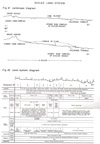
Several explanations have been offered for the contorted topography of parts o f the surface. E. S. Hills (1940 p. 189) postulates a "lava tunnel" under the newly formed skin of the basalt flow and its subsequent collapse after the molten lava had flowed out. He also considers that some of the ridges are the tongues of lava flows, whilst Boutakoff (1963) believes that pressure ridges "have formed on the sides of some of the flows". Lava blisters small domes of boulders, are thought to have been caused by the pressure of entrapped steam which lifted the congealing surface of the flow. Convincing examples of all types of suggested modes of formation have been seen in one or other of the land-units. These features have been preserved because of the very recent origin of the lava flows; this recent origin is shown by the surface boulders being angular and fitting closely into each other, by the boulders having been only slightly decomposed into soil with no filling-in of the swales, and by the fact that some trees appear to be the original colonists, as suggested later in this section. For the main part of the Eccles land-unit, collapsed lava tunnels seem to have played the most important part, with pressure ridges locally important near restrictions to the course of flow. On the other hand, edges of lava tongues seem to be important in producing the ruggedness of parts of the Napier unit, as one has the impression of a series of steps away from the Mount. These features are portrayed in the landscape diagram, Fig. 41.
The nature of the rock on the stony rises shows some variation (plate 39). At one extreme is moderately vesicular basalt, with the vesicles of varying size and discontinuous and the vesicle walls usually more than about 10 mms thick. The individual boulders of this type of basalt are generally fairly large, solid and blocky, and fit into each other very closely, in the flow. At the other extreme is scoriaceous olivine basalt, moderately to highly vesicular, with vesicles of varying size, generally continuous, but with a majority or the vesicle walls very thin, less than 5 mms and frequently less than 2 mms. The individual boulders of this material are rarely, more than 18 inches in diameter, usually 6 inches to 9 inches, of low density, jagged or roughly rounded and not fitting in with neighbouring boulders. Ropey lava, pahoehoe, is often found associated with this latter type. Between these two extremes is a continuous range of intermediates, but by far the greater part of the rocks examined during field traverses falls towards one extreme or the other, and in roughly equal proportions in the Eccles land-unit and possibly the Napier land-unit also. These differences in the rocks are chiefly physical, and hand-specimens show no obvious chemical differences, and all appear to be of the same composition as olivine basalt.
There are two further land forms of small extent. One is the scoria cones small, steep-sided convex hills of which Mount Napier and Mount Eccles themselves are the highest, rising to about 350 feet and 250 feet respectively above their surroundings; the others are smaller satellites of the Eccles group. These cones are composed of loose scoria of varying size, tuff and ropey lava, all interbedded, and some have craters and others have vents. Mt. Napier is the source of the surrounding stony-rise lava and it is possible, but by no means certain, that Mt. Eccles is on the site of the source of the stony-rise lava of the Eccles land-unit. The second land-form is the deposits of diatomite found on a few former lake beds amongst the stony rises, adjacent to Lake Condah. They form slightly elevated, springy banks of light grey silty material of very low density, and may be 6 feet or 7 feet thick. Surrounding such deposits are areas where the diatomite is thinner and mixed with soil weathering from the basalt. Before Lake Condah was drained, the seasonal water-table was higher than at present, and some adjacent areas of the stony rises, now dry, were swampy and water backed up the lava tunnels for some distance towards Mount Eccles. At some stage prior to white settlement, however, the regional water-table must have been much higher still, as shown by the deposits of diatomite, a lacustrine formation.
Apart from the brown earths of very limited extent on the cinder cones and diatomite, the chief soils of the land-system are restricted to a fairly narrow range between two extremes. The extremes are both brown earths, the Napier stony loam and the Dunmore organic loam. Shallow and normal phases of the former type are arbitrarily separated by a depth of 9 inches to the solid bottom of tightly-packed basalt boulders. The Napier stony loam is found only on the blocky basalt with thick walled vesicles, whilst the Dunmore organic loam is found only on the scoriaceous basalt with thin-walled vesicles, except on the very steep sides and troughs of collapsed tunnels or flows, where it can be formed from the blocky basalt as well. Consequently, since the two types of rocks are the extremes of a range, so also are the Napier stony loam and Dunmore organic loam the extremes of a range of soils. Intermediate soils therefore are found, and the above descriptions should not be regarded as representing self-contained groupings. However, just as for the rocks, by far the greater part of the profiles seem to fall towards one extreme or the other, and in roughly equal proportions, at least in the Eccles land-unit. The shallow phase of the Napier stony loam forms a scattered small minority of the whole. It has been separated because the depth of soil is likely to be an important feature for the growth of pine trees. Information is lacking as to the precise depth which is critical, so an arbitrary depth of 9 inches, found to be critical for bracken, which occurs naturally, was selected to allow an easy preliminary assessment of the situation.
Throughout the whole land-system, the vegetation is restricted to one association of one structural sub-formation, namely, the manna gum (Eucalyptus viminalis) association of the tall woodland sub-formation. The sole exception to this is the long thin tongue extending down the Byaduk valley to Louth and Condah swamps, and this tongue, apparently, has always been treeless. Blackwood (Acacia melanoxylon) and wild cherry (Exocarpus cupressiformis) are the only other trees in the association, and they occur sporadically but constantly throughout the land-system. Bracken (Pteridium aquilinum) and snow-grass (Poa australis) are the chief species of the understorey. The system is interesting in that it is the harbour, in the lava tunnels and caves, of rare ferns which have disappeared elsewhere in the Western District. For example, the fern Athyrium australe has been recorded only once previously in the Eccles land-unit, once in the Napier land-unit, and not at all elsewhere in western Victoria (Beauglehole and Learmonth 1957). Because of the disrupting effect of their boles and roots on the surface of the flow and the lack of similar disturbance between the trees, it seems that in some parts, the existing trees are the original colonists on the basalt.
The climate of the land-system varies only slightly, from about 30 inches average annual rainfall for most of the Eccles land-unit, to about 27 inches for the Napier land-unit. Most of the Eccles land-unit would have a growing period of seven and a half to eight months for a shallow-rooted species, including three months, June, July and August with temperatures too low for vigorous growth, whilst the Napier land-unit probably has about a month less of growing period.
Erosion hazard on the stony rises is completely absent except for the possibility of drastic mechanical disturbance of the Napier stony loam when exotic trees are planted. Should this happen, on the shallow phase of that type, the first few rains would wash the soil from the rocks downwards between them, leaving a jumble of boulders.
Less certain is the potential of the land-system. It is an example of land which in the early days of settlement carried abundant grass and afforded good grazing, but which now has worsened to a stage where it is difficult to see a return to the former state. The great amount of work put into the building of dry stone walls which criss-cross the land-system is an indication of the value of the grazing in the early days. Repeated burning however, combined with the free drainage and high fertility of the soils, encouraged bracken, which can withstand burning and requires good drainage, at the expense of the white tussock grass (Poa australis) and probably of perennial herbs as well. Almost the whole area is now bracken dominant, and sheep do not get much more than a picking. Nevertheless, the land-system is still valued locally as country on which to run dry Merino sheep.
Pines can probably be grown quite successfully.
This land-system is one of those which have been examined later in this report in further detail to illustrate the application of the survey methods at the more detailed stage. The potential land-use is considered more closely in that section of the report.
Both land-units, together with the stony rises around Camperdown and Colac, form a landscape which is unique in Australia. There are reports of the survival of koalas in the Napier land-unit. The best use of this country would be as a scenic, scientific and wild-life reserve.
© State of Victoria (Agriculture Victoria) 1996 - 2025.

This work, Victorian Resources Online, is licensed under a Creative Commons Attribution 4.0 licence. You are free to re-use the work under that licence, on the condition that you credit the State of Victoria (Agriculture Victoria) as author, indicate if changes were made and comply with the other licence terms.
The licence does not apply to ‘branding’ or some ‘images or photographs’ that may be owned by third parties. We ask you to seek prior approval to use images using the VRO feedback form. Access to higher quality images can also be provided on request.
This page was last updated on 23/03/2020.