
Dunkeld Land System
 |
|
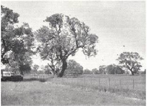 Plate 30 - Dunkeld land-system consists of undulating basaltic plains with occasional swamps, and formerly carried a woodland of red gums Plate 30 - Dunkeld land-system consists of undulating basaltic plains with occasional swamps, and formerly carried a woodland of red gums | The greater part of the basaltic plains of western Victoria has a flat to broadly undulating surface, few swamps, occasional subdued stony rises and is only slightly dissected except near a few major drainage lines. In the survey area, about 20,000 acres to the north and 3,000 acres to the south-east of Hamilton are of this character and have been mapped as the Dunkeld land-system. The parent material for this system is Dunkeld basalt which extends beyond the area of the survey around Dunkeld, Penshurst and Mortlake to the east, and around the Grampians to the north.
The parent materials are different from those of the Hamilton and Cobbobboonee land-systems, but similar to the Girringurrup and Eccles land-systems. There is no evidence of previous deep or intensive weathering of the basalt surface which later dissection has exposed as a remnant, and consequently there is no zoning of such parent material down a dissected slope. In contrast to the Girringurrup and Eccles land-systems however, there is evidence of different conditions or a longer period of soil formation because there is a greater difrerentiation of the horizons of the soil profile, and frequent accumulation of buckshot (ironstone) gravel. It is on the basis of this evidence and the relative degree of dissection that the Dunkeld basalt is considered to have been extruded later than the Hamilton and Cobbobboonee basalts but earlier than the Girringurrup and Eccles basalts. |
Grasslands or sparse savannah woodlands are typical of the Dunkeld land-system over the broader area of the Western District plains. In the survey area, however, sparse savannah woodlands with grassland understorey were the original vegetation-red gum (Eucalyptus camuldulensis) in the Croxton and Dunkeld land-units and swamp gum (E. ovata) in the Stratlikellar land-unit. Most of the trees have been cleared, leaving a grassland.
Three land-units are mapped. Croxton land-unit is a flat ridge elevated above a swampy area within the Hamilton land-system and as mapped includes the escarpment of underlying material. Dunkeld and Stratlikellar land-units north of Hamilton are differentiated by the Dunkeld land-unit having in-frequent swamps, very slight dissection to the Wannon River and a different original vegetation.
After settlement, the sparse savannah woodlands were dieal for Merino wool growing and much of the land-system is still used in this way. Some areas are developed more intensively with annual and perennial pastures based on late annual sub-clover and perennial ryegrass, with fodder cropping and fodder conservation. Cross-bred wool growing and beef cattle raising may be practised when the land has been improved in this way, and these enterprises may become more general over the land-system. The soils have a good chemical status in general and good moisture holding capacities. In contrast to the "red" land of the adjacent Hamilton land-system, namely the areas of Hamilton loam and Monivae loam, the more subdued topography of the Dunkeld land-system, the generally heavier surface textures of its soils, and the impeded internal soil drainage combine to make it slower to respond in the spring, but it retains green feed for longer into the summer. Cultivation of the soil is more difficult than in the Hamilton land-system.
Because the slopes are subdued in the Dunkeld land-system the erosion hazard is not high. In the Dunkeld and Stratlikellar land-units, some sheet erosion on the slopes concentrates water in shallow drainage lines, and the danger of scouring is aggravated by the presence of salted areas. For reasons already explained, the worst incidence of catchment salting may be expected in the Cavendish-Balmoral district in shallow catchments where solodic soils are common. This district contains most of the Dunkeld land-system, and in that part there is some severe salting. Salt-affected areas could be improved by the establishment of a denser perennial cover on the catchment, the fencing of the affected areas and the sowing down of the incipiently salted part with the appropriate species.
To summarise, the Dunkeld land-system is gently undulating basaltic country of the Western Plains with a few swamps and occasional creek-lines. It originally carried a sparse savannah woodland of red gum and native grasses ideal for Merino wool growing. Because the chief soils are fertile well-structured loams overlying clay, or dark cracking clays, annual and perennial pastures can be developed, with some fodder cropping to support cross-bred wool growing and beef cattle raising also. Erosion hazard is low but in some places there is salting of the soil.
© State of Victoria (Agriculture Victoria) 1996 - 2025.

This work, Victorian Resources Online, is licensed under a Creative Commons Attribution 4.0 licence. You are free to re-use the work under that licence, on the condition that you credit the State of Victoria (Agriculture Victoria) as author, indicate if changes were made and comply with the other licence terms.
The licence does not apply to ‘branding’ or some ‘images or photographs’ that may be owned by third parties. We ask you to seek prior approval to use images using the VRO feedback form. Access to higher quality images can also be provided on request.
This page was last updated on 23/03/2020.