SFS7
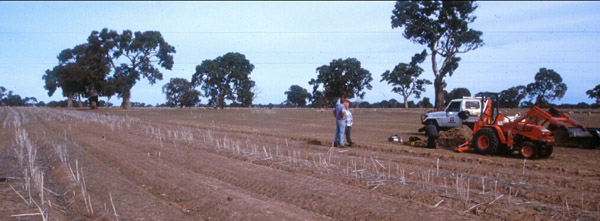
Location: South Mokanger
Soil Profile Morphology:
Key Profile Features:
Soil Profile Characteristics:
1 Strong dispersion after remoulding
Management Considerations:
Whole Profile
Page top
Aust. Soil Class.:Eutrophic, Mottled-Subnatric, Grey SODOSOL
 SFS 7 |
Soil Profile Morphology:
| Surface Soil |  SFS 7 | ||
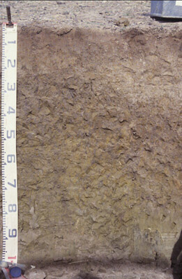
| A1 | 0-5 cm | Brown (10YR 4/3); fine sandy loam; apedal; weak surface seal; firm consistence; pH 5.6; abrupt change to: | |
| A2 | 5-25/30 cm | Brown (10YR 5/3 moist), conspicuously bleached (10YR 7/2 dry); sandy loam; rusty (10YR 4/6) root channel mottling; apedal; weak to firm consistence; pH 5.6; clear & wavy change to: | |
| Subsoil | |||
| B21 | 25/30-50 cm | Dark grey (10YR 4/1), with many (20-50%), fine yellowish brown (10YR 5/8) mottles; medium heavy clay; contains minor (1%) round buckshot; medium to coarse rough/irregular prismatic (40-80 mm), parting to rough blocky/polyhedral peds; pH 6.3; gradual change to: | |
| B22 | 50-80 cm | Olive brown (2.5Y 4/3-5/3); with yellowish brown (10YR 5/8) mottles; medium heavy clay; apedal; massive; sticky; minor rounded buckshot (5-10 mm); pH 6.5; gradual change to: | |
| B23 | 80 cm+ | Light olive brown (2.5Y 5/3 moist); with faint light yellowish brown (2.5Y 6/4) mottles; medium heavy clay; apedal; massive; sticky; few (1-5%) buckshot, some fine (<5 mm), rounded quartz; pH 6.7. | |
Key Profile Features:
- Strong texture contrast between surface (A) horizons and subsoil (B21) horizon.
- Conspicuously bleached subsurface (A2) horizon.
Soil Profile Characteristics:
pH | Salinity Rating | |||
Surface (A1 horizon) | Moderately Acid | Low | Non-Sodic | None |
Subsoil (B21 horizon) | Slightly Acid | Low | Sodic | None1 |
Deeper subsoil (at 1 m) | Slightly Acid | Low | Strongly Sodic | Strong-Complete |
 |
Horizon | Horizon Depth (cm) | pH (water) | pH (CaCl2) | EC dS/m | NaCl | Exchangeable Cations | |||
Ca | Mg | K | Na | ||||||
meq/100g | |||||||||
Ap | 5.6 | 4.9 | 0.15 | 3.5 | 1.4 | 0.24 | 0.38 | ||
A1 | 0-5 | 6.9 | 6.5 | 0.34 | 0.02 | 9.1 | 1.2 | 0.4 | <0.1 |
A2 | 5-25/30 | 5.6 | 4.7 | <0.05 | 0.77 | 0.49 | 0.07 | 0.11 | |
B21 | 25/30-50 | 6.3 | 4.8 | 0.09 | 4.6 | 9.4 | 0.4 | 2 | |
B22 | 50-80 | 6.5 | 5.1 | 0.14 | 4.5 | 12 | 0.44 | 3.5 | |
B23 | 80+ | 6.7 | 5.7 | 0.23 | 4.2 | 12 | 0.36 | 4.6 | |
Horizon | Horizon Depth (cm) | Exchangeable Aluminium mg/kg | Exchangeable Acidity meq/100g | Field Capacity pF2.5 | Wilting Point pF4.2 | Coarse Sand (0.2-2.0 mm) | Fine Sand (0.02-0.2 mm) | Silt (0.002-0.02 mm) | Clay (<0.002 mm) |
Ap | <10 | 6 | 16.4 | 6.4 | 26.3 | 47.1 | 10 | 13 | |
A1 | 0-5 | 4.7 | 19.8 | 10 | 23.9 | 45 | 11 | 13 | |
A2 | 5-25/30 | <10 | 1.9 | 12.6 | 2.2 | 30.2 | 49.7 | 12.5 | 8.5 |
B21 | 25/30-50 | 36 | 10 | 36.7 | 19.6 | 19 | 28.1 | 6.5 | 44 |
B22 | 50-80 | 10 | 42.4 | 22.3 | 14.7 | 26.4 | 6.5 | 49.5 | |
B23 | 80+ | 7.1 | 38.6 | 19.8 |
Management Considerations:
Whole Profile
- Plant available water capacity (PAWC) is considered to be low (estimated at 88 mm) in the upper 80 cm of this soil profile. Effective rooting depth (ERD) is restricted to 80 cm due to the highly sodic subsoils (ESP>20).
- Raised beds 1998, canola. Dry winter, no difference between beds and conventional (2+t/ha). Pit excavated in conventionally cultivated part of paddock to west side of beds. Midslope, gently sloping, flat, northerly aspect.
- Horizon Ap from a one year old raised bed which had been tilled once. Remaining horizons collected from undisturbed pasture.
- Profile described by Richard MacEwan, May 1999.


