
SFS7
Location: Mokanger
Ausralian Soil Classification: Eutrophic, Mottled-Subnatric, Grey SODOSOL
General Landscape Description: Victorian volcanic plains.
Site Description: Midslope, gently sloping.
Land Use: Raised bed canola cropping. Beds marked up after offset disk ploughing.
Geology: Basalt
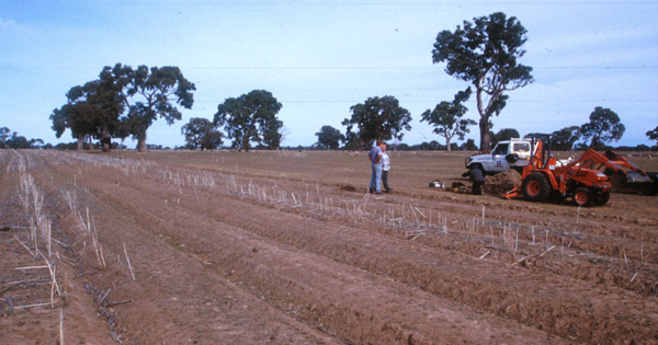 SFS7 Landscape |
Soil Profile Morphology:
| Surface Soil | 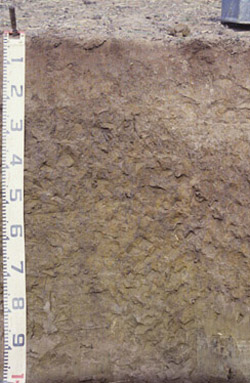 SFS7 Profile SFS7 Profile | ||
| A1 | 0-5 cm | Brown (10YR4/3); fine sandy loam; apedal; weak surface seal; firm consistence dry; pH 6.9; abrupt change to: | |
| A2 | 5-25/30 cm | Brown (10YR5/3), conspicuously bleached (10YR7/2 dry) with rusty (10YR4/6) root channel mottling; sandy loam; apedal; weak to firm consistence dry; pH 5.6; clear and wavy change to: | |
| Subsoil | |||
| B21 | 25/30-50 cm | Dark grey (10YR4/1) with many (20-50%) fine yellowish brown (10YR5/8) mottles; medium heavy clay; contains very few round buckshot; coarse rough/irregular prismatic, parting to rough blocky/polyhedral structure; pH 6.3; gradual change to: | |
| B22 | 50-80 cm | Olive brown (2.5Y4/3) with yellowish brown (10YR5/8) mottles; medium heavy clay; massive; consistence sticky; fine rounded buckshot; pH 6.5; gradual change to: | |
| B23 | 80 cm+ | Light olive brown (2.5Y5/3) with faint light yellowish brown (2.5Y6/4) mottles; medium heavy clay; massive; consistence sticky; few buckshot and some fine rounded quartz; pH 6.7. | |
Key Profile Features:
- Strong texture contrast between surface (A) horizons and subsoil (B21) horizon.
- Conspicuously bleached subsurface (A2) horizon.
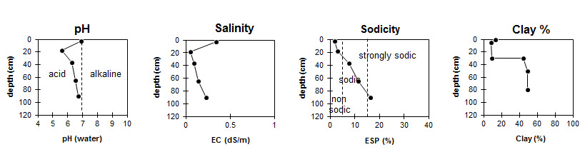
Soil Profile Characteristics:
pH | Salinity Rating | |||
Surface (A1 horizon) | Moderately Acid | Low | Non-Sodic | None |
Subsoil (B21 horizon) | Slightly Acid | Very Low | Sodic | None1 |
Deeper subsoil (at 1 m) | Slightly Acid | Low | Strongly Sodic | Strong-Complete |
Horizon | Horizon Depth (cm) | pH (water) | pH (CaCl2) | EC dS/m | NaCl % | Organic Carbon % | Nitrogen % | Exchangeable Cations | |||
Ca | Mg | K | Na | ||||||||
meq/100g | |||||||||||
Ap | 5.6 | 4.9 | 0.15 | 1.3 | 0.11 | 3.5 | 1.4 | 0.24 | 0.38 | ||
A1 | 0-5 | 6.9 | 6.5 | 0.34 | 0.02 | 9.1 | 1.2 | 0.4 | <0.1 | ||
A2 | 5-25/30 | 5.6 | 4.7 | <0.05 | 0.77 | 0.49 | 0.07 | 0.11 | |||
B21 | 25/30-50 | 6.3 | 4.8 | 0.09 | 4.6 | 9.4 | 0.4 | 2 | |||
B22 | 50-80 | 6.5 | 5.1 | 0.14 | 4.5 | 12 | 0.44 | 3.5 | |||
B23 | 80+ | 6.7 | 5.7 | 0.23 | 4.2 | 12 | 0.36 | 4.6 | |||
Horizon | Horizon Depth (cm) | Exchangeable Aluminium mg/kg | Exchangeable Acidity meq/100g | Field Capacity pF2.5 | Wilting Point pF4.2 | Coarse Sand (0.2-2.0 mm) | Fine Sand (0.02-0.2 mm) | Silt (0.002-0.02 mm) | Clay (<0.002 mm) |
Ap | - | <10 | 6 | 16.4 | 6.4 | 26 | 47 | 10 | 13 |
A1 | 0-5 | 4.7 | 19.8 | 10 | 24 | 45 | 11 | 13 | |
A2 | 5-25/30 | <10 | 1.9 | 12.6 | 2.2 | 30 | 50 | 13 | 9 |
B21 | 25/30-50 | 36 | 10 | 36.7 | 19.6 | 19 | 28 | 7 | 44 |
B22 | 50-80 | 10 | 42.4 | 22.3 | 15 | 26 | 7 | 50 | |
B23 | 80+ | 7.1 | 38.6 | 19.8 |
Management Considerations:
Whole Profile
- Plant available water capacity (PAWC) is considered to be low (estimated at 88 mm) in the upper 80 cm of this soil profile. Effective rooting depth (ERD) is restricted to 80 cm due to the highly sodic subsoils (ESP>20).
- Dry winter, no difference between beds and conventional (2+t/ha).
- Horizon Ap sample from a one year old raised bed which had been tilled once. Remaining horizons sample collected from undisturbed pasture.
© State of Victoria (Agriculture Victoria) 1996 - .

This work, Victorian Resources Online, is licensed under a Creative Commons Attribution 4.0 licence. You are free to re-use the work under that licence, on the condition that you credit the State of Victoria (Agriculture Victoria) as author, indicate if changes were made and comply with the other licence terms.
The licence does not apply to ‘branding’ or some ‘images or photographs’ that may be owned by third parties. We ask you to seek prior approval to use images using the VRO feedback form. Access to higher quality images can also be provided on request.
This page was last updated on .