
GL55
Location: Bolwarra
Australian Soil Classification: Ferric, Natric, Brown KUROSOL (confidence level 1)
General Landscape Description: Gently undulating plan
Site Description: Lower slope, 2%
Land Unit: Gorae Basalt
Geology:
General Land Unit Description: This land unit has a variety of soil types occurring over a short distance. This soil type, along with Ferrosols and Black Chromosols are found is association with the more dominant Ferric Brown Chromosols. The Brown Chromosols have been used to represent this area as they are deemed to be the major soil type, and due to restrictions of scale the other soil types have not been mapped as individual units. It must be noted however, that the better drained soils (Red Ferrosols / Dermosols) have a higher capability of supporting a range of land uses (e.g. viticulture) due to their favourable physical and chemical properties.
Soil Profile Morphology:
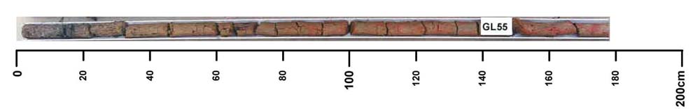
Surface
| A1 | 0-25 cm | Dark greyish brown (10YR4/2), sandy clay loam, weak angular blocky structure, strong consistence when dry, few small ferromanganiferous nodules (2-4 mm), pH 6.0; clear transition to: |
| Subsoil
| ||
| B1 | 25-40 cm | Dark yellowish brown (10YR4/4) light clay, moderate angular to subangular blocky structure, consistence firm when dry, many small subrounded ferromanganiferous nodules (2-5 mm), pH 5.6; gradual transition to:
|
| B21 | 40-75 cm | Yellowish brown (10YR5/4), light clay, faint medium orange and pale mottles are common, weak subangular blocky structure, consistence strong when dry, many small subrounded ferromanganiferous nodules (2-5 mm), pH 5.4; gradual transition to:
|
| B22 | 75-135 cm | Yellowish brown (10YR5/4), light medium clay, many distinct medium red, orange and pale mottles, consistence firm when dry, moderate subangular blocky structure, small to medium subangular ferromanganiferous nodules (2-10 mm) are common, pH 5.5; diffuse transition to:
|
| C | 135-200 cm | Many distinct coarse red and orange mottles pH 5.3. |
Key Profile Features:
- Strongly acidic subsoil
- Many ferromanganiferous nodules in subsoil
- Mottled subsoil
- Topsoil slightly dispersive when worked when wet
Soil Profile Characteristics:
- | pH | Salinity | ||
Surface Soil (A1 horizon) | Moderately Acid | Medium | Non-Sodic | None |
Subsoil (B21 Horizon) | Strongly Acid | Low | Sodic | None |
Deeper Subsoil (100-200 cm) | Strongly Acid | Medium | Non-Sodic | None |
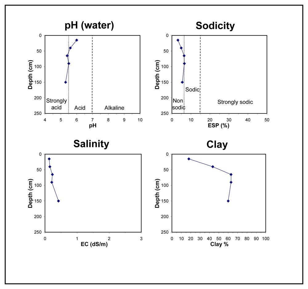
Chemical and Physical Analysis:
Horizon | Horizon Depth (cm) | pH (water) | pH (CaCl2) | EC dS/m | Organic Carbon % | Total Nitrogen % | Exchangeable Aluminium ppm | Exchangeable Acididty meq/100g | Exchangeable Cations | Coarse Sand (0.2-2.0 mm) % | Fine Sand (0.02-0.2 mm) % | Silt (0.002-0.02 mm) % | Clay (<0.002 mm) % | Field Capacity % w/w | Wilting Point % w/w | |||
Ca | Mg | K | Na | |||||||||||||||
meq/100g | ||||||||||||||||||
A1 | 0-30 | 6 | 5.4 | 0.13 | 1.1 | 0.06 | 12 | 7.4 | 2.9 | 1.4 | 0.26 | 0.39 | 7 | 55 | 17 | 18 | 18.8 | 8.3 |
B1 | 30-50 | 5.6 | 4.9 | 0.15 | 23 | 9.9 | 1.4 | 3.7 | 0.34 | 0.79 | 7 | 36 | 13 | 44 | 27.9 | 17.3 | ||
B21 | 50-80 | 5.4 | 5.2 | 0.23 | 11 | 12 | 2.1 | 4.6 | 0.26 | 1.3 | 5 | 22 | 8 | 63 | 35.7 | 25 | ||
B22 | 80-100 | 5.5 | 5.2 | 0.21 | 12 | 11 | 2.6 | 4.8 | 0.18 | 1.3 | 2 | 25 | 9 | 63 | 35.4 | 25.1 | ||
C | 100-200 | 5.3 | 5 | 0.42 | 17 | 11 | 3.5 | 4.5 | 0.1 | 1.1 | 5 | 24 | 9 | 60 | 40.7 | 25.6 | ||
Profile Described By: Natalie Baxter and Grant Boyle, 4th October 2000.
© State of Victoria (Agriculture Victoria) 1996 - 2025.

This work, Victorian Resources Online, is licensed under a Creative Commons Attribution 4.0 licence. You are free to re-use the work under that licence, on the condition that you credit the State of Victoria (Agriculture Victoria) as author, indicate if changes were made and comply with the other licence terms.
The licence does not apply to ‘branding’ or some ‘images or photographs’ that may be owned by third parties. We ask you to seek prior approval to use images using the VRO feedback form. Access to higher quality images can also be provided on request.
This page was last updated on 23/03/2020.