GL169
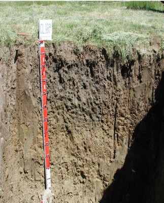
Australian Soil Classification: Eutrophic, Mottled-Subnatric, Grey SODOSOL (confidence level 1)
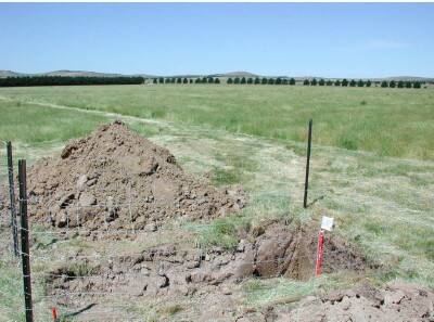
General Landscape Description: Level to gently undulating plain.
Site Description: Flat.
Land Unit: Ararat Alluvial.
Geology: Quaternary Alluvium.
General Land Unit Description: This soil represents the alluvial plains in the north east of the study area around Ararat and Moyston. The soils tend to be Black or Grey Sodosols, Vertosols or Vertic Chromosols. They are generally imperfectly drained and have very little relief.

Soil Profile Morphology:
Horizon | Depth (cm) | |||
A1 | 0-15 | Dark greyish brown (10YR4/2); clay loam; strong fine polyhedral structure; weak consistence, dry; contains a few fine rounded pebbles; pH 5.3; clear change to: |  | |
B21 | 15–40 | Dark grey (10YR4/1), with common distinct fine brownish yellow (10YR6/6) mottles; heavy clay; strong very coarse prismatic parting to moderate fine polyhedral structure; very firm consistence, dry; pH7.3; clear and wavy change to: | ||
B22 | 40–60 | Greyish brown (2.5Y5/2), with common fine faint yellow mottles (10YR7/6); heavy clay; pH 8.4; gradual and wavy change to: | ||
B23 | 60–90 | Light olive brown (2.5Y5/4), with distinct medium yellowish brown (10YR5/6) mottles; heavy clay; moderate angular blocky structure; very firm consistence, dry; pH 9.1; gradual and wavy change to: | ||
B24 | 90+ | Light yellowish brown (2.5Y3/6); heavy clay; pH 9.5. | ||
Soil Profile Characteristics:
- | pH | Salinity | ||
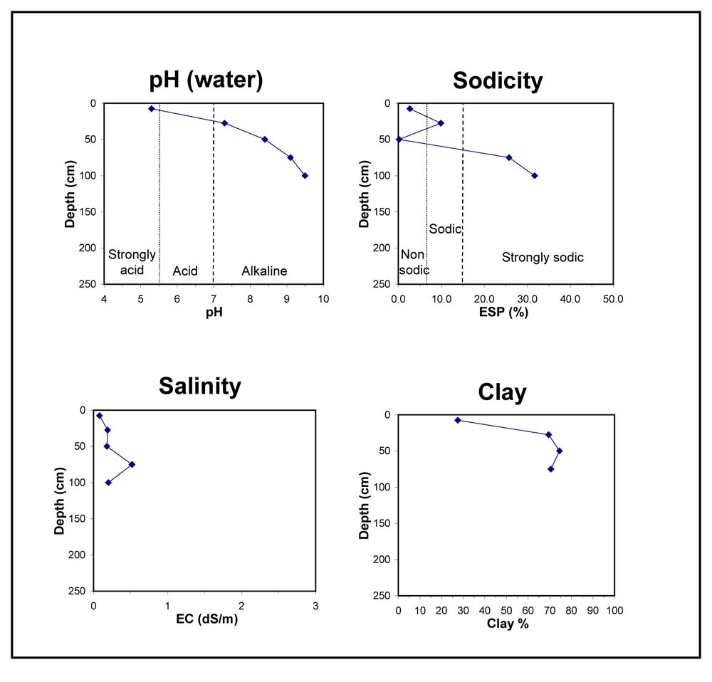
Surface Soil (A1 horizon) | Strongly Acid | Very Low | Non Sodic | None1 |
Subsoil (15-40 cm) | Slightly Alkaline | Low | Sodic | Complete |
Deeper Subsoil (90+cm) | Moderately Alkaline | Low | Strongly Sodic | Complete |

Chemical and Physical Analysis:
Horizon | Horizon Depth (cm) | pH (water) | pH (CaCl2) | EC dS/m | Organic Carbon % | Total Nitrogen % | Exchangeable Aluminium ppm | Exchangeable Acididty meq/100g | Exchangeable Cations | Coarse Sand (0.2-2.0 mm) % | Fine Sand (0.02-0.2 mm) % | Silt (0.002-0.02 mm) % | Clay (<0.002 mm) % | Field Capacity % w/w | Wilting Point % w/w | |||
Ca | Mg | K | Na | |||||||||||||||
meq/100g | ||||||||||||||||||
A1 | 0-15 | 5.3 | 4.3 | 0.08 | 2.6 | 0.24 | 69 | 14 | 3.6 | 3.1 | 0.55 | 0.59 | 7 | 38 | 22 | 28 | 30.8 | 12.3 |
B21 | 15–40 | 7.3 | 6.2 | 0.19 | 9.4 | 8.3 | 14 | 1.7 | 3.7 | 2 | 15 | 11 | 70 | 49.6 | 27.0 | |||
B22 | 40–60 | 8.4 | 7.3 | 0.18 | 8.7 | 17 | 1.7 | 0.05 | 2 | 12 | 8 | 75 | 50.8 | 28.4 | ||||
B23 | 60–90 | 9.1 | 8.4 | 0.52 | 6.6 | 16 | 1.8 | 8.5 | 3 | 15 | 10 | 71 | 49.4 | 27.0 | ||||
B24 | 90+ | 9.5 | 9.1 | 0.2 | 7.2 | 19 | 1.3 | 13 | ||||||||||
Key Profile Features:
- Acidic topsoil
- Topsoil dispersive when worked when wet
- Strongly dispersive subsoil when dry
- Sodic subsoil
- Deeper subsoil highly alkaline
- Mottled subsoil
Profile Described By: David Rees, December 2002.


