
GL168
Australian Soil Classification: Mesotrophic, Mottled-Mesonatric, Grey SODOSOL (confidence level 1) CHROMOSOL
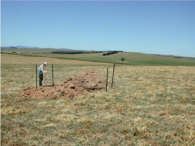
General Landscape Description: Low Hills.
Site Description: Lower, 6% slope.
Land Unit: Ararat Granites.
Geology: Ordovician granite.
General Land Unit Description: This land unit consists of granitic hills and rises around Ararat. Granitic tors are common on the crests and at the break of slope in some areas. Landslips are evident on the steeper slopes. This site is on a long slope off a rocky crest (GL167). Granite rock outcrop is common at the break-of-slope, although it is generally absent on the slope. The soils are deeper than GL167, although there is still a deep C horizon present. Soil depth is variable. The C horizon tends to act as a barrier for water penetration. The clay B22 horizon has an intermittent gleyed appearance that supports this. The prismatic and angular structure of the subsoil is probably a result of the high dispersibility of the clay. The dominant soil type is a Grey Sodosol, often found on the lower slopes, similar to this site. Chromosols are more likely to occur on the crests and steeper slopes. The steeper slopes and rocky crests would have a lower capability of supporting land use due to land and soil limitations.
Soil Profile Morphology:
Horizon | Depth (cm) | |||
A1 | 0–10 | Dark brown (7.5YR3/3); loamy coarse sand, weak medium polyhedral structure; very weak consistence, dry; contains a a few small angular pebbles, pH 5.4; gradual change to: | 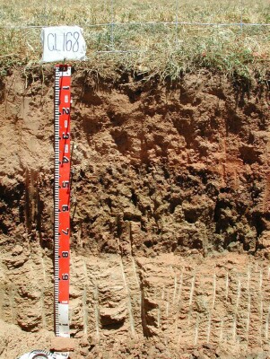 | |
A21 | 10–30 | Brown (7.5YR4/4); loamy coarse sand; massive structure; weak consistence, dry; pH 5.2; gradual change to: | ||
A22 | 30–40 | Brown (7.5YR5/4), conspicuously bleached (7.5YR7/4d); loamy coarse sand; massive structure; weak consistence, dry; pH 5.9; clear change to: | ||
B21 | 40–55 | Brown (10YR4/2), with many prominent fine dark red (2.5YR3/6) mottles; heavy clay; strong very coarse prismatic parting to strong very fine angular blocky structure; common clay skins evident; pH 7.4; clear and wavy change to: | ||
B22 | 55-80 | Weak red (10R5/3), with common medium prominent brownish yellow (10YR6/6) mottles; heavy clay; strong very coarse prismatic structure; contains very few fine manganiferous flecks; common clay skins evident; pH 7.9; sharp change of variable depth to: | ||
C | 80-180 | Weathered granite. | ||
Soil Profile Characteristics:
Soil Profile Characteristics:
- | pH | Salinity | ||
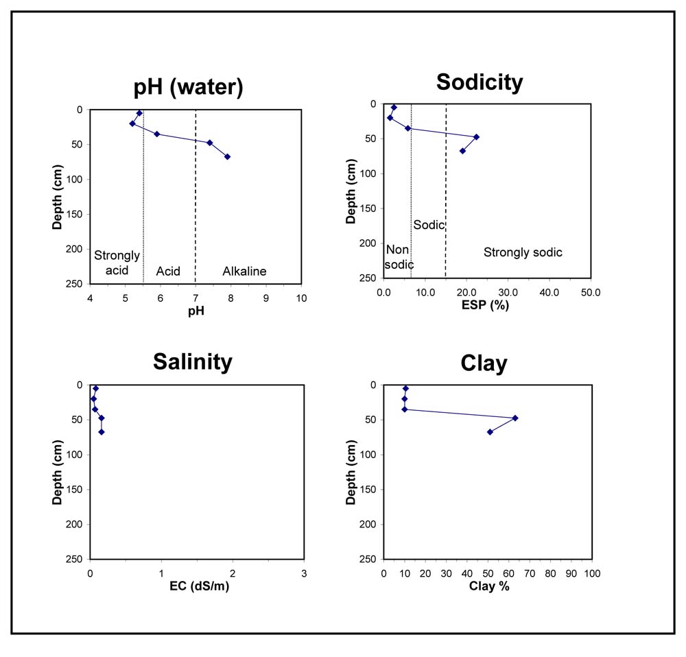
Surface Soil (A1 horizon) | Strongly Acid | Low | Non-Sodic | None |
Subsoil (40-55 cm) | Slightly Alkaline | Very Low | Strongly Sodic | None1 |
Deeper Subsoil (55-80 cm) | Slightly Alkaline | Low | Strongly Sodic | Complete |
Chemical and Physical Analysis:
Horizon | Horizon Depth (cm) | pH (water) | pH (CaCl2) | EC dS/m | Organic Carbon % | Total Nitrogen % | Exchangeable Aluminium ppm | Exchangeable Acididty meq/100g | Exchangeable Cations | Coarse Sand (0.2-2.0 mm) % | Fine Sand (0.02-0.2 mm) % | Silt (0.002-0.02 mm) % | Clay (<0.002 mm) % | Field Capacity % w/w | Wilting Point % w/w | |||
Ca | Mg | K | Na | |||||||||||||||
meq/100g | ||||||||||||||||||
A1 | 0–10 | 5.4 | 4.4 | 0.08 | 1.8 | 0.15 | 17 | 7 | 1.8 | 0.42 | 0.58 | 0.25 | 38 | 38 | 12 | 11 | 12.3 | 4.3 |
A21 | 10–30 | 5.2 | 4.5 | 0.05 | 25 | 3.9 | 0.77 | 0.31 | 0.18 | 0.08 | 42 | 35 | 12 | 10 | 11.4 | 3.7 | ||
A22 | 30–40 | 5.9 | 5.1 | 0.07 | <10 | 2.8 | 0.94 | 0.54 | 0.19 | 0.28 | 36 | 39 | 15 | 10 | 11.5 | 3.3 | ||
B21 | 40–55 | 7.4 | 6.2 | 0.16 | 0 | 5.2 | 7.2 | 0.94 | 3.8 | 11 | 18 | 7 | 63 | 39.1 | 22.6 | |||
B22 | 55-80 | 7.9 | 6.8 | 0.16 | 0 | 6.1 | 9.8 | 0.86 | 4 | 17 | 19 | 11 | 51 | 40.7 | 19.4 | |||
Key Profile Features:
- Sandy topsoil
- Acidic topsoil
- Strong texture contrast between topsoil and subsoil
- Strongly sodic subsoil
- Strong dispersive deeper subsoil
- Mottled subsoil
Profile Described By: David Rees, December 2002.
© State of Victoria (Agriculture Victoria) 1996 - 2025.

This work, Victorian Resources Online, is licensed under a Creative Commons Attribution 4.0 licence. You are free to re-use the work under that licence, on the condition that you credit the State of Victoria (Agriculture Victoria) as author, indicate if changes were made and comply with the other licence terms.
The licence does not apply to ‘branding’ or some ‘images or photographs’ that may be owned by third parties. We ask you to seek prior approval to use images using the VRO feedback form. Access to higher quality images can also be provided on request.
This page was last updated on 23/03/2020.