
Soil/Landform Unit - Horsham South flat plain
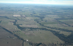 Looking north-east over the Horsham south flat plains and MacKenzie River towards Mount Zero and Green Lake |
1.60% of CMA region This unit of very low relative relief terrain includes plains and sand plains north of the Grampians Ranges and western Black Range, and south of Natimuk. These flat plains are derived from Quaternary alluvial, lacustrine and aeolian sediments that overlie older Cainozoic sediments linked to the tablelands in the south. There are four landform components including the level plain, sand plain (sandsheet), drainage lines and swamps. Drainage is dendritic and, along with swamps, is not overly incised into the landscape. Grey cracking clay soils (Vertosols) on plains and in local depressions occurs as well as yellow and grey sodic texture contrast soils (Sodosols). Periodic inundation and waterlogging can occur in the depressions and extensive flat areas. This unit is used for dryland cropping, grazing (sheep, beef cattle) and water supply. Remnant vegetation communities include Plains Woodland, Shallow Sands Woodland, Creekline Sedgy Woodland, Riparian Woodland, Red Gum Wetland and Plains Grassy Woodland. | 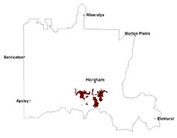 |
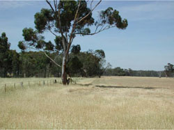 Plains north-east of Telngatuk | 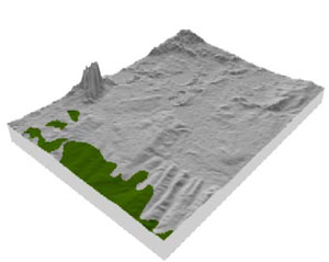 |
 | 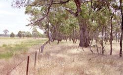 Roadside remnant vegetation |
Component | 1 | 2 | 3 | 4 |
Proportion of soil-landform unit | 85% | 10% | 2% | 3% |
| CLIMATE Rainfall (mm) | Annual: 555 | |||
| Temperature (oC) | Minimum 8, Maximum 21 | |||
| Precipitation less than potential evapotranspiration | October–April | |||
| GEOLOGY Age and lithology | Neogene marine sand and silt (Parilla Sand); Quaternary paludal silt and clay; Quaternary fluvial silt, sand and minor gravel (Shepparton Formation) | |||
| Geomorphology | ||||
| LANDUSE | Uncleared areas: water supply; nature conservation Cleared areas: dryland cropping; sheep and beef cattle grazing; water supply | |||
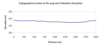
| TOPOGRAPHY Landscape | Flat plains | |||
| Elevation range (m) | 134–216 | |||
| Local relief (m) | 2 | |||
| Drainage pattern | Dendritic | |||
| Drainage density (km/km2) | 0.6 | |||
| Landform | Plains | |||
| Landform element | Level plain | Sandsheet | Drainage line | Swamp |
| Slope and range (%) | 1 (0-3) | 2 (1-5) | 1 (0-2) | 0 (0-1) |
| Slope shape | Straight | Linear | Concave | Concave |
| NATIVE VEGETATION Ecological Vegetation Class | Plains Woodland (50.0%), Creekline Sedgy Woodland (20.3%), Riparian Woodland (13.3%), Other (16.4%) | |||
| SOIL Parent material | Marine sand and silt | Aeolian sand, silt and clay | Alluvial gravel, sand and silt | Paludal silt and clay |
| Description (Corangamite Soil Group) | Cracking clay soils (23) | Sodic yellow and grey texture contrast soils (32) | Cracking clay soils (23) | Seasonally wet soils: sodic yellow and grey texture contrast soils (33) |
| Soil type sites | ||||
| Surface texture | Light clay | Loamy sand | Light clay | Sand |
| Permeability | Very slow | Moderate to high | Very slow | Slow to very slow |
| Depth (m) | > 2 | > 1.5 | > 2 | > 1.5 |
| LAND CHARACTERISTICS, POTENTIAL AND LIMITATIONS Critical land features, processes, forms | Flat areas susceptible to inundation and waterlogging, but can be variable locally due to micro relief (gilgai). Surface soils generally not friable and are susceptible to compaction (weakly structured). | Susceptible to wind and sheet erosion where exposed. Low inherent fertility but well drained to pans or subsoil. Susceptible to compaction where hardsetting and poor drainage occurs. | Drainage lines are susceptible to inundation and waterlogging. Surface soils generally not friable and are susceptible to compaction. | Susceptible to seasonal inundation, waterlogging and ultimately soil salinity. Surface soils susceptible to sheet erosion and wind erosion when exposed. |
© State of Victoria (Agriculture Victoria) 1996 - .

This work, Victorian Resources Online, is licensed under a Creative Commons Attribution 4.0 licence. You are free to re-use the work under that licence, on the condition that you credit the State of Victoria (Agriculture Victoria) as author, indicate if changes were made and comply with the other licence terms.
The licence does not apply to ‘branding’ or some ‘images or photographs’ that may be owned by third parties. We ask you to seek prior approval to use images using the VRO feedback form. Access to higher quality images can also be provided on request.
This page was last updated on .