
Soil/Landform Unit - Horsham South sand-clay plain
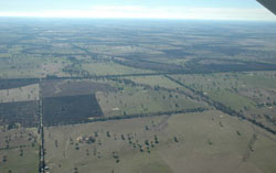 Looking north over the alluvial aprons and fans of the Mackenzie River, Burnt Creek and Norton Creek |
1.36% of CMA region The sand-clay plains between the Grampians Range in the east and the western Black Range in the west form part of the alluvial fans and aprons landscape (4.3) of the Wimmera CMA region. Comprising a sequence of Neogene to recent sedimentary deposits, the plains are very gentle with numerous sandsheets scattered amongst these sandy clay plains. Swamps also figure prominently with drainage systems of MacKenzie Creek, Burnt Creek and numerous channels that supply lakes and the Wimmera River further north. Soils are quite variable owing to sediment sources and include cracking clays (Vertosols), red sodic texture contrast soils (Sodosols) and deep sands (Tenosols and Podosols). Seasonal inundation can be an issue where depressions and flats occur during wet seasons. Soil compaction on the texture contrast soils is a management issue also. Land use is mainly cereal cropping along with pasture production and sheep grazing. There are a number of woodland vegetation communities including; Damp Sands Herb-rich Woodland, Heathy Woodland, Plains Grassy Woodland and Creekline Grassy Woodland for example. Other vegetation communities include herblands, wetlands, marshes and scrub. | 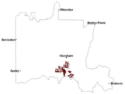 |
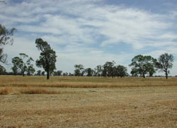 Plains with Buloke and red gum near Wonwondah South | 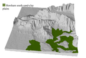 |
 | 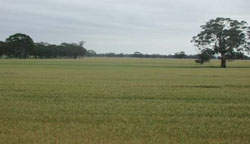 Cropped plains south-west of Mockinya |
Component | 1 | 2 | 3 | 4 | 5 |
Proportion of soil-landform unit | 5% | 30% | 5% | 10% | 50% |
| CLIMATE Rainfall (mm) | Annual: 590 | ||||
| Temperature (oC) | Minimum 8, Maximum 20 | ||||
| Precipitation less than potential evapotranspiration | October–March | ||||
| GEOLOGY Age and lithology | Neogene marine sand and silt (Parilla Sand); Quaternary paludal silt and clay; Quaternary alluvium, silt, sand and minor gravel (Shepparton Formation) | ||||
| Geomorphology | |||||
| LANDUSE | Uncleared areas: nature conservation; water supply Cleared areas: dryland cropping; sheep grazing | ||||
| TOPOGRAPHY Landscape | Sand and clay plain | ||||
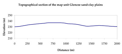
| Elevation range (m) | 124–323 | ||||
| Local relief (m) | 3 | ||||
| Drainage pattern | Dendritic | ||||
| Drainage density (km/km2) | 0.9 | ||||
| Landform | Plains | ||||
| Landform element | Creek/drainage line | Dune slope/sandsheet | Playa | Gentle rise | Level plain |
| Slope and range (%) | 1 (0-2) | 4 (3-10) | 0 (0-1) | 3 (2-8) | 2 (1-5) |
| Slope shape | Concave | Convex | Concave | Convex | Straight |
| NATIVE VEGETATION Ecological Vegetation Class | Plains Woodland (40.1%), Creekline Sedgy Woodland (20.4%), Heathy Woodland (7.7%), Riparian Woodland (6.7%), Other (25.1%) | ||||
| SOIL Parent material | Alluvial gravel, sand and silt | Aeolian dune sand and silt | Paludal silt and clay | Marine sand and silt | Fluvial and marine sand and silt |
| Description (Corangamite Soil Group) | Cracking clay soils (23) | Cracking clay soils (23) | Sodic red texture contrast soils (25) | ||
| Soil type sites | |||||
| Surface texture | Light clay | Loamy sand | Light clay | Fine sandy loam | Fine sandy loam - light clay |
| Permeability | Very slow | High | Very slow | Slow | Slow |
| Depth (m) | > 2 | > 2 | > 2 | > 2 | > 2 |
| LAND CHARACTERISTICS, POTENTIAL AND LIMITATIONS Critical land features, processes, forms | Drainage areas are susceptible to seasonal inundation and waterlogging, but can be variable locally due to micro relief (gilgai). Surface soils generally not friable and are susceptible to compaction (less structure). | Soils with low organic matter levels can be susceptible to wind and sheet erosion where exposed. Low inherent soil fertility. | Flat areas susceptible to seasonal inundation and waterlogging. Surface soils are generally not friable and are susceptible to compaction (less structure). | Hardsetting soil slightly susceptible to sheet and rill erosion. Soils are prone to compaction at critical moisture contents. Subsoil susceptible to gully erosion when exposed due to dispersive (sodic) nature. Slight susceptibility to acidification of surface soil. | Soils may be slightly susceptible to inundation and waterlogging where surface soil is shallow. Hardsetting soil slightly susceptible to sheet and rill erosion. Soils are prone to compaction at critical moisture contents. |
© State of Victoria (Agriculture Victoria) 1996 - .

This work, Victorian Resources Online, is licensed under a Creative Commons Attribution 4.0 licence. You are free to re-use the work under that licence, on the condition that you credit the State of Victoria (Agriculture Victoria) as author, indicate if changes were made and comply with the other licence terms.
The licence does not apply to ‘branding’ or some ‘images or photographs’ that may be owned by third parties. We ask you to seek prior approval to use images using the VRO feedback form. Access to higher quality images can also be provided on request.
This page was last updated on .