
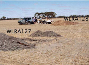
WLRA127
|
| WLRA127 | 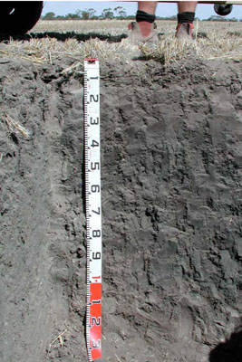 Epihypersodic-Endocalcareous, Epipedal, Grey Vertosol | |
|
Location | Borung Highway, Areegra, western Victoria | |||
|
Landform | Plain | |||
|
Geology | Quaternary Woorinen Formation: aeolian dune sand, calcareous clay | |||
|
Element | Flat | |||
|
Slope | 0% | |||
|
Aspect | – | |||
Horizon | Depth (cm) | Description | ||
Ap | 0–15 | Very dark greyish brown (10YR3/2); sandy clay loam; moderate medium to coarse polyhedral structure; rough ped fabric; very weak consistence when dry; moderately calcareous; many very fine roots; pH 8.5; smooth and clear boundary to: | ||
B1 | 15–40 | Dark grey (2.5Y4/1); light clay; weak coarse to very coarse platy, parting to very coarse and coarse angular blocky structure; rough ped fabric; firm consistence when dry; very fine to fine roots common; pH 8.5; wavy and clear boundary to: | ||
B21 | 40–75 | Very dark grey (2.5Y3/1); medium clay; strong coarse to very coarse prismatic, parting to medium to fine subangular blocky structure; smooth ped fabric; strong consistence when dry; very fine to fine roots common; pH 8.5; wavy and gradual boundary to: | ||
B22 | 75–100 | Dark grey (2.5Y4/1) with few medium faint grey mottles; medium clay; strong coarse to medium prismatic structure; rough ped fabric; very strong consistence when dry; few fine calcareous nodules (<2 mm); few fine to very fine roots; slightly calcareous; pH 8.5; wavy and gradual boundary to: | ||
B23 | 100–135+ | Light yellowish brown (2.5Y6/4) with few distinct large (2.5Y4/1) biological mixing; medium clay; moderate coarse polyhedral structure; rough ped fabric; strong consistence when moderately moist; few fine calcareous nodules, tubules and very coarse laminae; few very fine roots; very highly calcareous; pH 9.0. | ||
| Management considerations | ||||
| ||||
Site WLRA127 | Sample depth cm | pH | EC dS/m | NaCl % | Ex Ca cmol-/kg | Ex Mg cmol-/kg | Ex K cmol-/kg | Ex Na cmol-/kg | Ex Al mg/kg | Ex acidity cmol-/kg | FC -30okPa | PWP -1500okPa | KS % | FS % | Z % | C % | |
Horizon | H2O | CaCl2 | |||||||||||||||
A1 | 0–15 | 8.2 | 7.9 | 0.27 | 0.15 | 1.8 | NA | 21 | 2.8 | 3.8 | 0.1 | Considerable | 3(2) | 23 | 22.1 | 21 | 23.5 |
B1 | 15–40 | 8.3 | 8 | 0.26 | 0.1 | 1.5 | NA | 22 | 3.4 | 2.2 | 0.4 | Considerable | 5 | 23.6 | 20.9 | 21.5 | 29 |
B21 | 40–75 | 8.6 | 7.7 | 0.11 | NA | NA | NA | 22 | 8.6 | 1.6 | 1.6 | Considerable | 2(3) | 20.1 | 11.4 | 25 | 37.5 |
B22 | 75–100 | 8.8 | 7.7 | 0.12 | NA | NA | NA | 19 | 9.3 | 1.5 | 2.8 | Considerable | 2(3) | 28.2 | 14.7 | 14.5 | 38.5 |
B23 | 100–135+ | 9.4 | 8.6 | 0.29 | NA | NA | NA | 12 | 9.5 | 1.4 | 4.7 | Considerable | 1 | 26.3 | 15.9 | 13.5 | 39 |
Description of sample | pH | E.C.
dS/m | T.S.S.
% w/w | Total C
% w/w | Org.Mat
% w/w | Total N
% w/w | Olsen P
mg/kg | Skene K
mg/kg | CPC S
mg/kg | Field BD
kg/L | |
H2O | CaCl2 | ||||||||||
WLRA127 bulk sample (A1) | 8.2 | 7.8 | 0.23 | NA | NA | NA | NA | 26 | 1300 | 14 | NA |
© State of Victoria (Agriculture Victoria) 1996 - .

This work, Victorian Resources Online, is licensed under a Creative Commons Attribution 4.0 licence. You are free to re-use the work under that licence, on the condition that you credit the State of Victoria (Agriculture Victoria) as author, indicate if changes were made and comply with the other licence terms.
The licence does not apply to ‘branding’ or some ‘images or photographs’ that may be owned by third parties. We ask you to seek prior approval to use images using the VRO feedback form. Access to higher quality images can also be provided on request.
This page was last updated on .