
Soil/Landform Unit - Arapiles steep hills
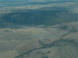
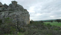
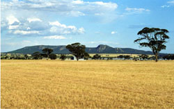 The sedimentary stack of Mt Arapiles standing above stranded beach ridges (rises) and cropped undulating plains near Natimuk |
0.20% of CMA region Mount Arapiles provides a topographically significant landform with plains to the east and the Douglas Depression to the north, south and west flanking the steep sandstone hills. Composed of Grampians Group sandstone, this sedimentary stack was used by Major Mitchell to gain a vantage point over the plains of north-west Victoria. The steep hills are characterised by steep to precipitous slopes and a relatively obscure summit at around 300 m. The main vegetation types include Plains Woodland and Shallow Sand Woodland with smaller areas of shrubland (such as Rocky Outcrop Shrubland and Sandstone Ridge Shrubland), Heathy Woodland and grasslands are also found in this area. Soils are dominated by shallow (Rudosols), sandy (Tenosols) and gradational to texture contrast (Kandosols) soils with an abundance of sand throughout the profile. The scarps and cliff faces attract numerous climbing enthusiasts throughout the year, however rockfall provides a hazard to climbers. The high sand content of soils makes them extremely prone to wind and sheet erosion where insufficient ground coverage exists. |  |
 Mt Arapiles and Mitre Rock | 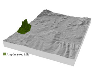 |
|
|
Component | 1 | 2 | 3 | 4 | 5 |
Proportion of soil-landform unit | 15% | 55% | 10% | 10% | 10% |
| CLIMATE Rainfall (mm) | Annual: 500 | ||||
| Temperature (oC) | Minimum 8, Maximum 21 | ||||
| Precipitation less than potential evapotranspiration | September–April | ||||
| GEOLOGY Age and lithology | Silurian marine and non-marine fluvial sandstone and siltstone with minor conglomerate (Grampians Group); Neogene marine sands and silts (Parilla Sand) | ||||
| Geomorphology | |||||
| LANDUSE | Uncleared areas: nature conservation; recreation activities (e.g. rock climbing) Cleared areas: dryland cropping; Sheep grazing | ||||
| TOPOGRAPHY Landscape | Steep hills | ||||
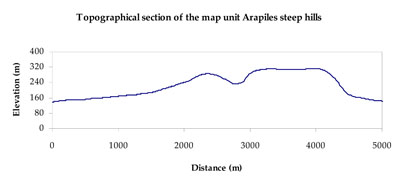
| Elevation range (m) | 119–360 | ||||
| Local relief (m) | 200 | ||||
| Drainage pattern | Radial | ||||
| Drainage density (km/km2) | 0.3 | ||||
| Landform | Hills | Rises | |||
| Landform element | Scarp/cliff | Moderate hillslope | Colluvial slope/fan | Plateau | Rolling rise |
| Slope and range (%) | 40 (10-70) | 10 (5-25) | 3 (1-7) | 6 (1-15) | 3 (0-10) |
| Slope shape | Convex | Linear | Straight | Linear to convex | Convex to concave |
| NATIVE VEGETATION Ecological Vegetation Class | Shallow Sands Woodlands (37.1%), Plains Woodland (19.7%), Rocky Outcrop Shrubland/Rocky Outcrop Herbland Mosaic (12.2%), Scree-slope Grassland/Woodland Mosaic (9.7%), Other (19.6%) | ||||
| SOIL Parent material | In situ quartzose sandstone and siltstone | In situ quartzose sandstone and siltstone | Colluvial gravel, sand and silt | In situ quartz, sandstone and siltstone | Sand, silt and clay |
| Description (Corangamite Soil Group) | Sandy gradational soils (14) | Shallow and sandy soils, sodic brown texture contrast soils (41) | |||
| Soil type sites | GRAMP335 | ||||
| Surface texture | Sandy loam | Sandy loam | Loamy sand | Sandy loam | Loamy sand |
| Permeability | High | Moderate to high | High | Moderate to high | High |
| Depth (m) | 0-0.7 | > 2 | > 0.6 | 1.5 | > 0.6 |
| LAND CHARACTERISTICS, POTENTIAL AND LIMITATIONS Critical land features, processes, forms | Light sandy soils subject to mass movement (creep and sheet flow) on very steep slopes, generally rapidly drained to hardpan or rock. Rock falls also pose a threat on steepest slopes. Weakly coherent surfaces with little organic matter are susceptible to sheet and wind erosion where exposed. Acidic soils with low inherent fertility. | Light sandy surface soils well drained. Weakly coherent surfaces with little organic matter are susceptible to sheet and wind erosion where exposed. Acidic, low inherent fertility surface soils. | Light sandy soils that rapidly drain to a hardpan, clay subsoil or rock. Weakly coherent surfaces with little organic matter are susceptible to sheet and wind erosion where exposed. Acidic soil surface with low inherent soil fertility soils that are slightly susceptible to further acidification. | Light sandy surface soils that are well drained. Weakly coherent surfaces with little organic matter are susceptible to sheet and wind erosion where exposed. Acidic, low inherent fertility surface soils. | Weakly coherent surfaces with little organic matter are susceptible to sheet and wind erosion where exposed. Acidic soil surface with low inherent soil fertility soils that are slightly susceptible to further acidification. |
© State of Victoria (Agriculture Victoria) 1996 - .

This work, Victorian Resources Online, is licensed under a Creative Commons Attribution 4.0 licence. You are free to re-use the work under that licence, on the condition that you credit the State of Victoria (Agriculture Victoria) as author, indicate if changes were made and comply with the other licence terms.
The licence does not apply to ‘branding’ or some ‘images or photographs’ that may be owned by third parties. We ask you to seek prior approval to use images using the VRO feedback form. Access to higher quality images can also be provided on request.
This page was last updated on .