
41. Shallow and sandy soils, sodic brown texture contrast soils/Hills and low hills
|
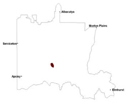
These soils have developed on Palaeozoic sediments, generally of Grampians sandstone making up Mount Arapiles, outlying in the North West Dunefields and Plains, south of the Little Desert. Soils are either Rudosols, sandy soils such as Tenosols or heavier soils such as Sodosols on the footslopes. The soils are acidic in higher positions but may be alkaline in lower positions (accumulation zones).
|  |
Soil Sites
Site code | Soil-landform unit | Component | ASC | FK | 1:100 000 mapsheet |
| WLRA54 | Arapiles steep hills | Hillslope | Bleached-Leptic, Tenosol | Gn1.84 / Uc2.21 | T7324 - Horsham |
| NA172 | Arapiles steep hills | Hillslope | Eutrophic, Mesonatric, Brown Sodosol | Dr3.43 | T7224 - Natimuk |
© State of Victoria (Agriculture Victoria) 1996 - .

This work, Victorian Resources Online, is licensed under a Creative Commons Attribution 4.0 licence. You are free to re-use the work under that licence, on the condition that you credit the State of Victoria (Agriculture Victoria) as author, indicate if changes were made and comply with the other licence terms.
The licence does not apply to ‘branding’ or some ‘images or photographs’ that may be owned by third parties. We ask you to seek prior approval to use images using the VRO feedback form. Access to higher quality images can also be provided on request.
This page was last updated on .