
WLRA54
|
| WLRA54 | 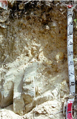 Basic, Lithic Bleached-Leptic, Tenosol | |
|
Location | Mount Stapylton, western Victoria | |||
|
Landform | Mountains | |||
|
Geology | Silurian-Devonian Grampians Group: quartz sandstone and red siltstone | |||
|
Element | Hillslope | |||
|
Slope | 50% | |||
|
Aspect | North | |||
Horizon | Depth (cm) | Description | ||
A11 | 0–5 | Light brownish grey (10YR 5/2); loamy sand;) to weak medium polyhedral structure parting to single grain (structureless); very weak consistence, pH 5.5; clear boundary to: | ||
A12 | 5–15 | Brownish yellow (10YR 5/3); loamy sand; weak polyhedral structure; weak consistence; pH 6.0; clear boundary to: | ||
A2 | 15–30 | Yellow (10YR6/4); silty loam; moderate medium polyhedral structure; rough ped-fabric; firm consistence; pH 6.0; gradual boundary to: | ||
B2 | 30–60/70 | Brownish yellow (10YR 6/6); sand; angular blocky parting to single grain (structureless); loose consistence. | ||
B2 | 60/70–70 | Brownish yellow (10YR 6/6); loamy sand; angular blocky parting to single grain (structureless); loose consistence; abundant sandstone. | ||
C | 70+ | Weathering sandstone. | ||
| Management considerations | ||||
| ||||
© State of Victoria (Agriculture Victoria) 1996 - .

This work, Victorian Resources Online, is licensed under a Creative Commons Attribution 4.0 licence. You are free to re-use the work under that licence, on the condition that you credit the State of Victoria (Agriculture Victoria) as author, indicate if changes were made and comply with the other licence terms.
The licence does not apply to ‘branding’ or some ‘images or photographs’ that may be owned by third parties. We ask you to seek prior approval to use images using the VRO feedback form. Access to higher quality images can also be provided on request.
This page was last updated on .