
Erosion in Victoria (1938)
Photo gallery
The following document regarding the state of erosion in Victoria was published in 1938. Briefly, it contains a discussion of the types of erosion found as well as their causes, effects, reclamation and control. Measures appropriate for erosion control on both state- and privately-owned land were also considered.
To view the information PDF requires the use of a PDF reader. This can be installed for free from the Adobe website (external link).
 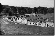 Gully through grassland at Bindi, Upper Tambo, 25 ft to 30 ft deep (1938) | Part 1 Erosion in Victoria (PDF 137KB) | Appendix - Types of Erosion Sheet Erosion (PDF 570KB) |
Appendix - Types of Erosion Gully Erosion (PDF 559KB) | Appendix - Types of Erosion Stream Erosion (PDF 201KB) | |
Appendix - Types of Erosion Landslides (PDF 176KB) | Appendix - Types of Erosion Wind (PDF 156KB) | |
Appendix - Types of Erosion Siltation (PDF 381KB) | Appendix - Types of Erosion Methods of Control (PDF 281KB) |
Photo gallery
© State of Victoria (Agriculture Victoria) 1996 - .

This work, Victorian Resources Online, is licensed under a Creative Commons Attribution 4.0 licence. You are free to re-use the work under that licence, on the condition that you credit the State of Victoria (Agriculture Victoria) as author, indicate if changes were made and comply with the other licence terms.
The licence does not apply to ‘branding’ or some ‘images or photographs’ that may be owned by third parties. We ask you to seek prior approval to use images using the VRO feedback form. Access to higher quality images can also be provided on request.
This page was last updated on .