
Soil
Victoria has a wide variety of soil types that reflect differences in soil forming processes dictated by factors such as geology, landform, stream activity, vegetation, climate and age (i.e. degree of weathering). Soil underpins the productive potential of Victorian agriculture and forestry and the majority of soils are generally highly productive under good management practices.
Victorian Resources Online presents a wide range of soil information where a number of broadscale soil maps of Victoria are presented. More detailed soil maps and information will be progressively developed.
| Victorian Soils Map | 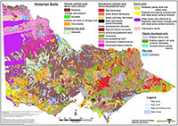 |
Soils Information and Where to Find It
Soil and soil related information can be found on VRO according to scale and chronology. Generally, most soils information is not located at this State level but within each Catchment Management Authority (CMA): Wimmera, Glenelg-Hopkins, Corangamite, Mallee, Port Phillip and Westernport, West Gippsland, East Gippsland, North East, Goulburn Broken and North Central.
Within each catchment management region:
- Broad scale landscape mapping with associated soils information can be found under the Landform section and then under Land Systems within each region (one level up from the Soil page). These studies are generally at a scale of 1:250 000.
- Mid scale soils information can be found under the Soil section then under Soil/Landform Mapping . These studies are generally at a scale of 1:100 000. Examples include the Land Resource Assessment (soil/landscape mapping) studies carried out for many of the catchment management regions.
- Finer scale (more detailed) soils information can also be found under the Soil section as Detailed Soil Surveys. These are generally at a scale of 1:25 000 to 1:32 000 and mainly cover irrigation regions.
- Other soils information can be found under the Land Use section as part of Land Capability Studies/Assessments (one level up from the Soil page). These surveys are generally at a landscape mapping scale of 1:25 000.
The Soil and Land Survey Directory allows you to access soil and land survey information by searching within a specific Local Government Areas (LGA) or catchment management (CMA) region.
| Soil Health Soil Health refers to the 'fitness' (or condition) of soil to support specific uses (e.g. crop growth). This section provides a range of information on soil health, including a 'soil health checklist', 'soil health management plan', information sheets and key legacy documents. Soil pH Overview maps of surface and subsoil pH for Victoria, together with general information about soil pH and its significance for agriculture. Soil Texture Overview maps of soil surface and subsoil texture for Victoria. Soil Sodicity Sodicity is a key issue that influences soil behaviour. A new map showing the distribution of sodic subsoils in Victoria is available here. Soil Matters This section provides information generated from key workshops led by the Department, as well as events involving Soil Science Australia. Reports from workshops, recent project outputs and upcoming events. | 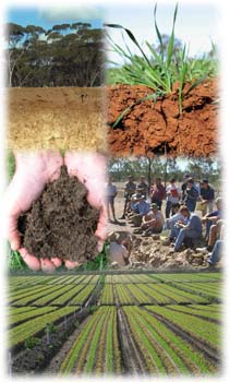 |
Soil and Land Survey Directory
Contains details of over 100 major soil and land surveys conducted in Victoria. Also, provides information on the history of soil survey in Victoria.
Soil Management
By understanding the behaviour of soils we can maximise their use in a sustainable way.
Soil structural degradation, nutrient decline, acidification and erosion can occur for many soils which are poorly managed.
Coastal Acid Sulfate Soils
Soil and Landscape Animations
Victorian State Soil
A State Soil of Victoria was selected by the Victorian Branch of the Australian Society of Soil Science Inc (ASSSI) during 2005. This section provides details of this process and information about a range of contenders for State Soil.
Soils Glossary
Related Reports
Trace Elements for Pastures and Animals in Victoria
The Monolith Collection (1962-1988)
Related Links
DEPI Agnote: What is Soil?
Australian Agriculture Assessment 2001 (external link) - information about Australian agriculture; agriculture profile; changing face of agriculture; landscape balances; nutrient management; soil acidification; soil erosion and nutrient loads.
Australian Soil Resource Information System (external link)
Land Theme Report (external link) prepared for State of the Environment (SOE) 2001 reporting - on the Department of the Environment and Heritage website. Includes information on: soil erosion, soil and land pollution, and secondary salinity and acidity in Australia.
The Australian Collaborative Land Evaluation Program (ACLEP) website (external link) provides information about soil and land survey collaboration in Australia - including an online version of the Australian Soil Classification.
The Soil Knowledge Exchange website (external link) is the web component of the Soil Knowledge Brokering Service being supported by the Victorian Catchment Management Council. The Soil Knowledge Exchange provides an aggregation of knowledge resources and links related to soils, as well as being a portal linking the soils community. Its function is to support and complement rather than substitute for other soils web resources.
Fertiliser Regulation in Victoria - DEPI regulates the content and labelling of fertilisers sold in Victoria to manage the risks from heavy metals and other contaminants in fertilisers. Continued use of fertilisers containing high levels of certain heavy metal contaminants in agricultural situations may lead to the accumulation of these contaminants in soils and residue levels in plant and animal products above Australian or international standards.
| Additional regional soils information |
© State of Victoria (Agriculture Victoria) 1996 - .

This work, Victorian Resources Online, is licensed under a Creative Commons Attribution 4.0 licence. You are free to re-use the work under that licence, on the condition that you credit the State of Victoria (Agriculture Victoria) as author, indicate if changes were made and comply with the other licence terms.
The licence does not apply to ‘branding’ or some ‘images or photographs’ that may be owned by third parties. We ask you to seek prior approval to use images using the VRO feedback form. Access to higher quality images can also be provided on request.
This page was last updated on .