
Land Degradation in Victoria
S.C. Boucher
School of Geography and Environmental Science
Monash University, Victoria 3800
McTainsh and Boughton (1993) remarked that causes of land degradation can be natural, such as the bushfires, droughts and floods initiated by climatic factors, whilst others including the use of fire by Australian Aborigines and poor farming practices by European settlers are directly attributable to human activities. They classified land degradation into three main types with the major subtypes listed in parentheses; soil erosion and deposition (water and wind erosion), soil degradation (soil salinity and degradation of soil structure) and ecosystem change (degradation of vegetation). A recent assessment of the status of various types of land degradation in Victoria was made in the 1991 State of the Environment Report entitled `Agriculture and Victoria's Environment' (Commission for the Environment, 1992), whilst an introduction to the historical geography of land degradation in this State is provided by the research of Powell (1975; 1976; 1989).
What appears to be one of the earliest examples of accelerated (ie. man-induced) land degradation in Victoria following European settlement was reported by John G. Robertson in a letter to Lieutenant-Governor Charles La Trobe dated 26 September, 1853. The letter, part of which is reproduced below, referred to land in the Casterton and Coleraine areas of southwestern Victoria.
| "Many of our herbaceous plants began to disappear from the pasture land; the silk-grass began to show itself in the edge of the bush track, and in patches here and there on the hill. The patches have grown larger every year; herbaceous plants and grasses give way for the silk-grass and the little annuals, beneath which are annual peas, and die in our deep clay soil with a few hot days in spring, and nothing returns to supply their place until later in the winter following. The consequence is that the long deep-rooted grasses that held our strong clay hill together have died out; the ground is now exposed to the sun, and it has cracked in all directions, and the clay hills are slipping in all directions; also the sides of precipitous creeks-long slips, taking trees and all with them. When I first came here, I knew of but two landslips, both of which I went to see; now there are hundreds found within the last three years. A rather strange thing is going on now. One day all the creeks and little watercourses were covered with a large tussocky grass, with other grasses and plants, to the middle of every watercourse but the Glenelg and Wannon, and in many places of these rivers; now that the only soil is getting trodden hard with stock, springs of salt water are bursting out in every hollow or watercourse, and as it trickles down the watercourse in summer, the strong tussocky grasses die before it, with all others. The clay is left perfectly bare in summer. The strong clay cracks; the winter rain washes out the clay; now mostly every little gully has a deep rut; when rain falls it runs off the hard ground, rushes down these ruts, runs into the larger creeks, and is carrying earth, trees, and all before it. Over Wannon country is now as difficult a ride as if it were fenced. Ruts, seven, eight, and ten feet deep, and as wide, are found for miles, where two years ago it was covered with tussocky grass like a land marsh. I find from the rapid strides the silk-grass has made over my run, I will not be able to keep the number of sheep the run did three years ago, and as a cattle station it will be still worse; it requires no great prophetic knowledge to see that this part of the country will not carry stock that is in it at present..."(Bride, 1898, 168-9). |
Boucher and Powell (1994) noted that Robertson and the settlers nearby were essentially obliged to make empirical tests on the surrounding environment, to its considerable cost and, therefore, erosion in that district was accentuated if not triggered in the late 1830s and 1840s.
Periodically soil erosion has been portrayed as a significant environmental and economic problem. There were numerous references to locally severe soil erosion in Victoria during the late 19th and early 20th centuries. Particular reference was made in the 1920s and 1930s to sand drift in the Mallee and water erosion in the hilly country of the northeast (S.M. Legg, pers.comm.). A report concering Erosion in Victoria (1938) was published in February 1938 and in late 1939 a conference was held on the topic of 'Soil Erosion in Victoria' (Clark, 1940). By the 1940s, soil erosion had become a major public concern Australia-wide. In the introduction to Pick's (1942) book on soil erosion, Robert Croll's first paragraph read as follows:
| "War has come to Australia. The danger is real indeed but, I say it deliberately, not more real than the insidious threat by an enemy we have had with us for years. We can, and will, repel the foe now hammering our frontiers-we are eager and willing to enter the lists against him ; but we are actually encouraging and assisting this other enemy, civilization's greatest menace, soil erosion." |
In 1946, J. Macdonald Holmes, Professor of Geography at the University of Sydney, wrote a textbook on `Soil Erosion in Australia and New Zealand' and entitled the second chapter as `Soil-erosion the greatest peace-time social problem'.
| An early map of the incidence and hazard of wind and water erosion in Victoria was prepared from information supplied by the Soil Conservation Board and published in 1944. Sheet, rill, gully and tunnel erosion and concomitant siltation were marked as were the locations of landslides, stream erosion and siltation and drift sand. Briefly, drift sand accumulations were recorded in the Mallee and various types of water erosion were observed in the uplands, the hazard for erosion by wind and water respectively being acute in both areas. | 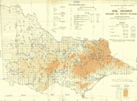 Soil Erosion - State Regional Boundaries Committee (1944) (PDF 337KB) |
References
Boucher, S.C. and Powell, J.M., 1994: Gullying and tunnel erosion in Victoria. Australian Geographical Studies 32, 17-26.
Clark, C.T., (ed.). 1940: Soil Erosion in Victoria. Department of Lands and Survey (Victoria), Government Printer, Melbourne.
Commission for the Environment, 1992: 1991 State of the Environment Report: Agriculture & Victoria's Environment. Office of the Commissioner for the Environment, Melbourne.
McTainsh, G.H. and Boughton, W.C., 1993: Land degradation in Australia - an introduction. In McTainsh, G.H. and Boughton, W.C. (eds) Land Degradation Processes in Australia. Longman Cheshire, Melbourne, 3-16.
Legg, S.M.,: Personal communication, 2000. Lecturer in the School of Geography and Environmental Science, Monash University, Victoria 3800.
Macdonald Holmes, J., 1946: Soil Erosion in Australia and New Zealand. Angus and Robertson, Sydney.
Pick, J.H., 1942: Australia's Dying Heart - soil erosion in the inland. Melbourne University Press in association with Oxford University Press, Melbourne and London.
Powell, J.M., 1975: Conservation and resource management in Australia, 1788-1860. In Powell, J.M. and Williams, M. (eds) Australian Space Australian Time: geographical perspectives. Oxford University Press, Melbourne, 18-60.
Powell, J.M., 1976: Environmental Management in Australia 1788-1914. Guardians, improvers and profit: an introductory survey. Oxford University Press, Melbourne.
Powell, J.M., 1989: Watering the Garden State - Water, land and community in Victoria 1834-1988. Allen & Unwin, Sydney.
Robertson, J.G., 1853: Letter to Lieutenant-Governor Charles La Trobe dated 26 September, 1853. In Bride, T.F. 1898 (ed.) Letters from Victorian Pioneers. Government Printer, Melbourne,.
Smyth, C., 1983: Parwan Valley Slide Set. Soil Conservation Authority of Victoria, Kew.
State Regional Boundaries Committee, 1944: Report on Regional Boundaries. Government Printer, Melbourne.
© State of Victoria (Agriculture Victoria) 1996 - .

This work, Victorian Resources Online, is licensed under a Creative Commons Attribution 4.0 licence. You are free to re-use the work under that licence, on the condition that you credit the State of Victoria (Agriculture Victoria) as author, indicate if changes were made and comply with the other licence terms.
The licence does not apply to ‘branding’ or some ‘images or photographs’ that may be owned by third parties. We ask you to seek prior approval to use images using the VRO feedback form. Access to higher quality images can also be provided on request.
This page was last updated on .