
Soil/Landform Unit 77
Landform Unit Description
Page top
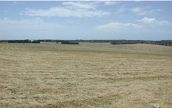
 Undulating plain with post harvest cropping scene |
0.97% of CMA region This single undulating rises and plain (plateau) unit is bounded by a scarp Unit 83 and alluvial plains (Unit 200) to the west, coastal plain Unit 199 and dunefields to the south and east and basaltic low hills (Unit 80) to the north. Unit components are upper plain, rises and drainage lines. The soils are brown, black or grey (often ferruginous) mottled texture contrast soils (Chromosols) associated with ferruginised sand. Translocation of organo-clay complexes to the upper subsoil are characteristic. The texture contrast soils are susceptible to sheet and rill erosion surface nutrient decline and wind erosion, depending on slope and topographical position. This is a generally dry area and land use consists of grazing, cropping, horticulture (grapes, olives, flowers and some potatoes) and recreation (old railway line cycle path). | 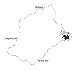 |
 Undulating plain with greater dissection to the east | 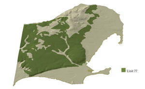 |
 |  Flower growing on Neogene level plain with basaltic hills in the background |
Component | 1 | 2 | 3 |
Proportion of soil-landform unit | 80% | 10% | 10% |
| CLIMATE Rainfall (mm) | Annual: 610 | ||
| Temperature (oC) | Minimum 10, Maximum 19 | ||
| Precipitation less than potential evapotranspiration | October-April | ||
| GEOLOGY Age and lithology | Neogene fluvial-marine sediments, Recent clay, sand and gravel and coastal sand dunes | ||
| Geomorphology | |||
| LANDUSE | Uncleared: Nature conservation Cleare: Regional development; cropping (cereal); sheep and beef cattle grazing | ||
| TOPOGRAPHY Landscape | Undulating rises and plains | ||
| Elevation range (m) | 3-107 | ||
| Local relief (m) | 50 | ||
| Drainage pattern | Dendritic | ||
| Drainage density (km/km2) | 1.0 | ||
| Landform | Rises | ||
| Landform element | Upper plain | Rise slope | Drainage depression |
| Slope and range (%) | 2 (1-8) | 4 (1-12) | 1 (0-3) |
| Slope shape | Straight | Straight | Convex |
| NATIVE VEGETATION Ecological Vegetation Class | Grassy Woodland (3.8%); Heathy Woodland (0.4%) | ||
| SOIL Parent material | Sand, silt and clay, often ferruginised | Sand, silty and clay, often ferruginised | Alluvium and sand, silt and clay, often ferruginised |
| Description (Corangamite Soil Group) | Brown mottled (red and yellow) texture contrast soils with bleached A2 horizons, occasionally ferric horizons withouut bleach (13) | Mottled brown or yellow sodic texture contrast soil (14) | |
| Soil type sites | CLRA3, CLRA18, CLRA30 | CLRA33, 204, CLRA2 | |
| Surface texture | Fine sandy loam | Fine sandy loam | Loam fine sandy |
| Permeability | Imperfectly | Moderate | Low |
| Depth (m) | <2 | <1.5 | >2 |
| LAND CHARACTERISTICS, POTENTIAL AND LIMITATIONS | Large texture contrast, low water holding capacity and nutrient holding capacity in light subsurface and surface soil, higher in subsoil. Heavy upper subsoil has clay skins. Slow to moderate site drainage. Susceptibility to surface soil nutrient and structure decline, slight compaction, sheet and wind erosion. | Large texture contrast, low water holding capacity and nutrient holding capacity in light subsurface and surfce soil, higher in subsoil. Heavy upper subsoil has clay skins. Moderate site drainage. Susceptibility to surface soil nutrient and structure decline, slight compaction, sheet and wind erosion. | Large texture contrast, low water holding capacity and nutrient holding capacity in light subsurface and surface soil, higher in subsoil. Heavy sodic upper subsoil has clay skins. Very slow site drainage. Susceptiblity to surface soil nutrient and structure decline, slight compaction, sheet and wind erosion. |
© State of Victoria (Agriculture Victoria) 1996 - .

This work, Victorian Resources Online, is licensed under a Creative Commons Attribution 4.0 licence. You are free to re-use the work under that licence, on the condition that you credit the State of Victoria (Agriculture Victoria) as author, indicate if changes were made and comply with the other licence terms.
The licence does not apply to ‘branding’ or some ‘images or photographs’ that may be owned by third parties. We ask you to seek prior approval to use images using the VRO feedback form. Access to higher quality images can also be provided on request.
This page was last updated on .