
Soil/Landform Unit 199
Landform Unit Description
Page top
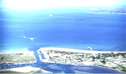
 Coastal dunefield at Queenscliff |
0.09% of CMA region This dunefield unit has small occurrences on the Bellarine Peninsula either as dunefields around Indented Head or as coastal plains (with sandsheets) west of Queenscliff. These occurrences are adjacent to the coast with other coastal units adjoining them (Units 82 and 197). Unit components comprise dunes and depressions. The soils are sands (Tenosols, Podosols) or sands over clay (texture contrast Sodosols). The dunes are very rapidly drained but susceptible to wind and sheet erosion, particularly where vegetation cover is removed. Nutrient decline (retention) is a land degradation susceptibility issue also. The lower terrain and depressions are susceptible to waterlogging. Land use is grazing (sheep and beef), minor cropping, recreation and mineral extraction. | 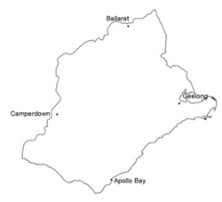 |
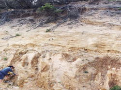 Calcareous dune deposit at Point Lonsdale |  |
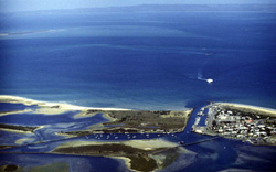
 |  Queenscliff-Sorrento Ferry about to mourn at Queenscliff |
Component | 1 | 2 |
Proportion of soil-landform unit | 80% | 20% |
| CLIMATE Rainfall (mm) | Annual: 610 | |
| Temperature (oC) | Minimum 10, Maximum 19 | |
| Precipitation less than potential evapotranspiration | October-April | |
| GEOLOGY Age and lithology | Recent clay, sand and gravel, Neogene fluvio-marine sand and Cretaceous fluvio-volcanic sandstone and conglomerate | |
| Geomorphology | ||
| LANDUSE | Uncleared: Nature conservation; passive recreation Cleared: Sheep and beef cattle grazing, residential, mineral extraction | |
| TOPOGRAPHY Landscape | Dunefield; undulating plains and rises | |
| Elevation range (m) | 2–72 | |
| Local relief (m) | 2–20 | |
| Drainage pattern | Dendritic | |
| Drainage density (km/km2) | 0.7 | |
| Landform | Dunefields | |
| Landform element | Dune and sandsheet | Depression |
| Slope and range (%) | 6 (0–25) | 2 (0–8) |
| Slope shape | Convex | Concave |
| NATIVE VEGETATION Ecological Vegetation Class | Calcarenite Dune Woodland (6.1%), Grassy Woodland (0.6%), Damp Sands Herb-rich Woodland (0.5%), Other (0.7%) | |
| SOIL Parent material | Sand, silt and clay | Sand, silt and clay |
| Description (Corangamite Soil Group) | Calcareous sands and sodic brown often mottled texture contrast soils (12) | |
| Soil type sites | ||
| Surface texture | Loamy sand | Loamy sand |
| Permeability | Very high | High to very high |
| Depth (m) | > 2 | > 2 |
| LAND CHARACTERISTICS, POTENTIAL AND LIMITATIONS | Deep sands or sands over clay. Often unconsolidated material with low water and nutrient holding capacity in sands. Susceptible to sheet and wind erosion. | Deep sands or sands over clay or texture contrast. Often unconsolidated material with low water and nutrient holding capacity in sands or lighter upper soil. Susceptible to sheet and wind erosion. |
© State of Victoria (Agriculture Victoria) 1996 - .

This work, Victorian Resources Online, is licensed under a Creative Commons Attribution 4.0 licence. You are free to re-use the work under that licence, on the condition that you credit the State of Victoria (Agriculture Victoria) as author, indicate if changes were made and comply with the other licence terms.
The licence does not apply to ‘branding’ or some ‘images or photographs’ that may be owned by third parties. We ask you to seek prior approval to use images using the VRO feedback form. Access to higher quality images can also be provided on request.
This page was last updated on .