
CLRA02
Location: Curlewis, Drysdale district.
Australian Soil Classification: Melanic-Vertic, Eutrophic, Black CHROMOSOL
General Landscape Description: Undulating Rises
Site Description: Mid slope
Geology: Neogene Hanson Plain Sand: fluvial gravel, sand, silt
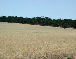
CLRA2 Landscape. Undulating rises of the Drysdale area
Soil Profile Morphology:
Surface Soil
A11/Ap | 0–5 cm | Dark brown (10YR3/2); loam fine sandy; very few (2–6 mm) sub-rounded quartz coarse fragments; weak fine subangular blocky structure; roughfabric; weak consistence dry; pH 5.5; smooth abrupt boundary to: | 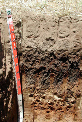 CLRA2 Profile CLRA2 Profile | |||
A12 | 5–25 cm | Dark brown (10YR3/2); loam fine sandy; very few (2–6 mm) sub-rounded quartz coarse fragments; massive structure; earthy fabric; firm consistence dry; pH 4.8; smooth clear boundary to: | ||||
A2 | 25–45 cm | Brown (7.5YR4/2); occasional bleach (10YR6/2; dry); sandy clay loam; very few (2–6 mm) sub-rounded quartz coarse fragments; massive structure; earthy fabric; firm consistence dry; few (6–60 mm) ferromanganiferous nodules; pH 5.5; wavy clear boundary to: | ||||
| Subsoil | ||||||
| B21 | 45–70 cm | Very dark grey (7.5YR3/1) with few medium brown distinct mottles; medium clay; strong coarse prismatic, parting to strong medium angular blocky, parting to strong fine polyhedral structure; smooth fabric; strong consistence dry; common clay skin and other cutans; pH 6.5; wavy gradual boundary to: | ||||
B22 | 70–100 cm | Strong brown (7.5YR4/6) with many very large very dark grey (7.5YR3/1) prominent mottles; light medium clay; strong coarse prismatic, parting to strong medium angular structure; smooth fabric; strong consistence dry; common clay skin and other cutans; pH 8.0; wavy abrupt boundary to: | ||||
B3k | 100–115 cm | Light yellowish brown (10YR6/4) with few medium very dark grey (10YR3/1) prominent mottles; light medium clay; moderate coarse prismatic, parting to strong medium angular structure; smooth fabric; common clay skin and other cutans; very firm consistence dry; few medium organic and argillaceous tubules; many large calcareous soft segregations; pH 8.5; wavy abrupt boundary to: | ||||
C1 | 115–135 cm | Brown (7.5YR4/3) with few medium very dark grey (10YR3/1) prominent mottles; heavy sandy clay loam; l massive structure; earthy fabric; very firm consistence dry; few medium organic and argillaceous tubules; pH 9.0; wavy abrupt boundary to: | ||||
C2/R | 135–145+ cm | Strong brown (7.5YR4/6) with few medium very dark grey (10YR3/1) prominent mottles; sandy clay loam; massive structure; earthy fabric; very firm consistence dry; few large ferruginous fragments; pH 9.0. | ||||
Soil Profile Characteristics:
Horizon | Sample Depth (cm) | pH (water) | pH (CaCl2) | EC 1:5 | Exchangeable Cations | |||
Ca | Mg | K | Na | |||||
meq/100g | ||||||||
A11/AP | 0–5 | 6.1 | 5.6 | 0.15 | 3.7 | 0.77 | 1.1 | 0.17 |
A12 | 5–25 | 4.8 | 4 | <0.05 | 1.5 | 0.3 | 0.46 | 0.06 |
A2 | 25–45 | 5.4 | 4.7 | 0.05 | 2.4 | 0.45 | 0.3 | 0.1 |
B21 | 45–70 | 6.4 | 5.5 | 0.1 | 17 | 7.4 | 1.2 | 0.65 |
B22 | 70–100 | 7.3 | 6.6 | 0.14 | 18 | 9.3 | 1.2 | 0.86 |
B3k | 100–115 | 8.3 | 7.8 | 0.23 | 25 | 6.8 | 0.76 | 0.75 |
C1 | 115–135 | 8.2 | 7.5 | 0.11 | N/R | N/R | N/R | N/R |
C2/R | 135–145 | 8.5 | 7.9 | 0.23 | 17 | 5.3 | 0.43 | 0.77 |
Horizon | Sample Depth (cm) | Exchangeable Aluminium mg/kg | Exchangeable Acidity cmolc/kg | Field Capacity pF2.5 | Wilting Point pF4.2 | Coarse Sand (0.2- 2.0 mm) | Fine Sand (0.02- 0.2 mm) | Silt (0.002- 0.02 mm) | Clay (<0.002 mm) |
A11/AP | 0–5 | <10 | 5.9 | 17.6 | 5.6 | 18.8 | 60.8 | 5.5 | 10 |
A12 | 5–25 | 110 | 9 | 17.5 | 4.7 | 17.5 | 61 | 7 | 11 |
A2 | 25–45 | 15 | 5.3 | 16.1 | 4.1 | 20.7 | 58 | 10.5 | 10.5 |
B21 | 45–70 | 11 | 11 | 42.4 | 23.9 | 10.8 | 23.3 | 4 | 58 |
B22 | 70–100 | 47.6 | 23.3 | 3.5 | 32.1 | 4.5 | 57 | ||
B3k | 100–115 | 37.8 | 17.0 | - | - | - | - | ||
C1 | 115–135 | - | - | - | - | - | - | ||
C2/R | 135–145 | 26.5 | 11.5 | 19.9 | 43.9 | 3.5 | 28 |
Management Considerations:
- Strong texture contrast between the surface soil and the subsoil is a very important soil feature. This can have a major effect by reducing and/or redirecting the internal drainage and restricting root growth due to greater resistance, gas and water throttles as well as associated chemical deterrents to growth. Options include reduced tillage, improving organic matter content and altering the subsoil through artificial drainage (ripping, mole drainage) and/or chemical amelioration (gypsum) to improve structure.
- Mottling usually indicates periodic waterlogging.
- The upper soil is very light and is dependent on maintaining or increasing organic matter levels (OC: Ap;1.0%) to reduce the susceptibility to sheet and rill erosion(in conjunction with slope) as well as increasing the low water holding and nutrient holding capacity.
- The whole profile has a slight [Emerson class 3] susceptibility to dispersion, increasing slightly in the lower subsoil [Emerson class 3(3)] but more stable where the carbonate increases [Emerson class 5].
Profile Described By: David Rees (December 2002).
Source: Robinson et al (2003) A land resource assessment of the Corangamite region. Department of Primary Industries, Centre for Land Protection Research Report No. 19
© State of Victoria (Agriculture Victoria) 1996 - .

This work, Victorian Resources Online, is licensed under a Creative Commons Attribution 4.0 licence. You are free to re-use the work under that licence, on the condition that you credit the State of Victoria (Agriculture Victoria) as author, indicate if changes were made and comply with the other licence terms.
The licence does not apply to ‘branding’ or some ‘images or photographs’ that may be owned by third parties. We ask you to seek prior approval to use images using the VRO feedback form. Access to higher quality images can also be provided on request.
This page was last updated on .