
Soil/Landform Unit 200
Landform Unit Description
Page top
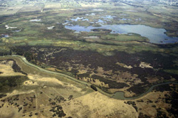 The Moolap Sunklands have a very diverse range of wildlife and habitats in this very unique wetlands within the Corangamite CMA region |
0.54% of CMA region Across the dissected sedimentary plains of the Western Plains are numerous swamps and closed depressions that host a wide variety of flora and fauna. These permanent swamps have been identified as occurring south of Geelong on Recent clay, sand and gravels, coastal sand dunes and minor basalt. Many of the swamps have been cleared previously with some untouched by land clearance. Vegetation classes of these swamps include Coastal Saltmarsh, Reed Swamp, Plains Freshwater Sedge Wetland, Cane Grass-lignum Halophyllic Herbland and Calcarenite Dune Woodland. Land use is mainly restricted to grazing owing to the waterlogged state of soils in most years. Soils include the grey cracking clays and sandy soils that reflect Recent alluvium deposits. While waterlogging is the major limitation, salinity is also expressed at the surface in many of these swamps as spiny rush. |  |
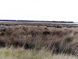 Located west of Barwon Heads, this swamp forms part of the Moolap Sunklands. The vegetation most prominent here is the Reed Swamp class | 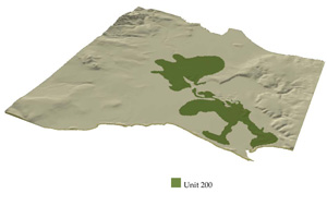 |
 | 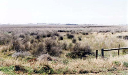 Reed swamp vegetation class of the Moolap Sunklands |
Component | 1 | 2 | 3 | 4 |
Proportion of soil-landform unit | 2% | 38% | 40% | 20% |
| CLIMATE Rainfall (mm) | Annual: 640 | |||
| Temperature (oC) | Minimum 9, Maximum 19 | |||
| Precipitation less than potential evapotranspiration | October–March | |||
| GEOLOGY Age and lithology | Quaternary clay, sand and gravel, coastal sand dunes and minor basalt | |||
| Geomorphology | ||||
| LANDUSE | Uncleared: Nature conservation; water supply Cleared: Cropping (cereal); sheep and beef cattle grazing | |||
| TOPOGRAPHY Landscape | Swamps and depressions associated with sedimentary plains | |||
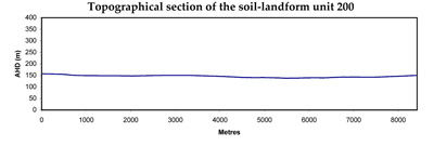
| Elevation range (m) | 4–148 | |||
| Local relief (m) | 1–2 | |||
| Drainage pattern | Deranged | |||
| Drainage density (km/km2) | 2.7 | |||
| Landform | Alluvial plains | |||
| Landform element | Dune | Depressions | Swamp | Undulating plain |
| Slope and range (%) | 2 (0–5) | 1 (0–2) | 1 (0–2) | 2 (1–4) |
| Slope shape | Convex | Straight | Straight | Convex |
| NATIVE VEGETATION Ecological Vegetation Class | Coastal Saltmarsh (20.5), Reed Swamp (8.3%), Plains Freshwater Sedge Wetland (1.3%), Cane Grass-Lignum Halophyllic Herbland (1.2%), Calcarenite Dune Woodland (1.1%) | |||
| SOIL Parent material | Aeolian sediments; clay silt and sand | Sedimentary derived alluvium; clay silt and sand | Sedimentary derived alluvium; clay silt and sand | Sedimentary derived alluvium; clay silt and sand |
| Description (Corangamite Soil Group) | Grey and black clays (31) | Grey and black clays (31) | Grey and black clays (31) | Grey and black clays (31) |
| Soil type sites | ||||
| Surface texture | Light clay | Light clay | Light clay | Light clay |
| Permeability | High | Low | Low | Low |
| Depth (m) | >2 | >2 | >2 | >2 |
| LAND CHARACTERISTICS, POTENTIAL AND LIMITATIONS | Uniform expansive clays, high to very high water holding capacity and nutrient holding capacity depending on depth. Sodic subsoils, surface soils may be self-mulching. Low site drainage. Susceptibility to waterlogging. | Uniform expansive clays, high to very high water holding capacity and nutrient holding capacity depending on depth. Sodic subsoils, surface soils may be self-mulching. Low site drainage. Susceptibility to waterlogging. | Uniform expansive clays, high to very high water holding capacity and nutrient holding capacity depending on depth. Sodic subsoils, surface soils may be self-mulching. Very low site drainage. Susceptibility to waterlogging. | Uniform expansive clays, high to very high water holding capacity and nutrient holding capacity depending on depth. Sodic subsoils, surface soils may be self-mulching. Low site drainage. Susceptibility to waterlogging. |
© State of Victoria (Agriculture Victoria) 1996 - .

This work, Victorian Resources Online, is licensed under a Creative Commons Attribution 4.0 licence. You are free to re-use the work under that licence, on the condition that you credit the State of Victoria (Agriculture Victoria) as author, indicate if changes were made and comply with the other licence terms.
The licence does not apply to ‘branding’ or some ‘images or photographs’ that may be owned by third parties. We ask you to seek prior approval to use images using the VRO feedback form. Access to higher quality images can also be provided on request.
This page was last updated on .