
Soil/Landform Unit 80
Landform Unit Description
Page top
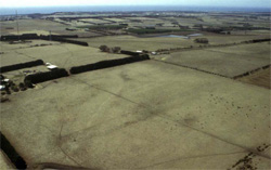 Rolling low hills on Paeaeogene volcanics (basalt), the highest landform on the Bellarine Peninsula |
0.20% of CMA region This single unit of hills on Palaeogene basic volcanics is the highest terrain on the Bellarine Peninsula and is surrounded by the Neogene sedimentary plateau. There are only two components; the rounded crests and the rolling convex slopes. The soils are black friable self-mulching (and cracking) clays. The soils have a friable surface which may be reduced due to sheet erosion depending on slope and topographic position. The strongly structured cracking clay sits clearly over weathered rock/saprolite. The expansive clays may be detrimental to sensitive root systems if shrink-swell behaviour is common in the subsoil (through artificial watering). Land use is grazing, cropping, horticulture (grapes, olives) and quarrying. |  |
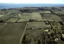 Rolling low basaltic hills supporting intensive agriculture such as viticulature and olives | 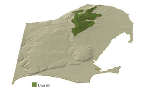 |
 | 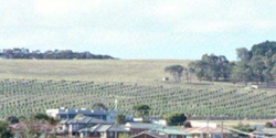 Olive plantation on basaltic slopes with urban encroachment in the foreground |
Component | 1 | 2 |
Proportion of soil-landform unit | 10% | 90% |
| CLIMATE Rainfall (mm) | Annual: 680 | |
| Temperature (oC) | Minimum 10, Maximum 19 | |
| Precipitation less than potential evapotranspiration | October-March | |
| GEOLOGY Age and lithology | Paleogene tholeite and pyroclastics, Neogene fluvio-marine sand | |
| Geomorphology | ||
| LANDUSE | Uncleared; Nature conservation; passive and active recreation Cleared areas: Sheep and beef cattle grazing; minor broadacre cropping (cereal); horticulture; quarrying | |
| TOPOGRAPHY Landscape | Low hills | |
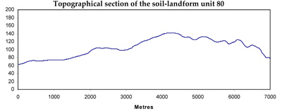
| Elevation range (m) | 8-143 | |
| Local relief (m) | 40 | |
| Drainage pattern | Dendritic | |
| Drainage density (km/km2) | 1.2 | |
| Landform | Hills | |
| Landform element | Crest | Hillslope |
| Slope and range (%) | 3 (0-10) | 6 (0-15) |
| Slope shape | Convex | Concave to convex |
| NATIVE VEGETATION Ecological Vegetation Class | Grassy Woodland (2.3%) | |
| SOIL Parent material | Basalt | Basalt |
| Description (Corangamite Soil Group) | Self-mulching and cracking black clay soils (30) | Self-mulching and cracking black clay soils (30) |
| Soil type sites | ||
| Surface texture | Light clay | Light clay |
| Permeability | Moderate | Low |
| Depth (m) | <1 | <1.5 |
| LAND CHARACTERISTICS, POTENTIAL AND LIMITATIONS | Expansive clay soils with friable self-mulching surfaces provide a good seedbed, but this is dependent on strict moisture conditions and shrink-swell tension on sensitive roots. High water holding and nutrient holding capacity. Susceptibility to sheet erosion on solopes and minor waterlogging in depressions. | Expansive clay soils with friable self-mulching surfaces provide a good seedbed, but this is dependent on strict moisture conditions and shrink-swell tension on sensitive roots. High water holding and nutrient holding capacity. Susceptibility to sheet erosion on slopes and minor waterlogging in depressions. |
© State of Victoria (Agriculture Victoria) 1996 - .

This work, Victorian Resources Online, is licensed under a Creative Commons Attribution 4.0 licence. You are free to re-use the work under that licence, on the condition that you credit the State of Victoria (Agriculture Victoria) as author, indicate if changes were made and comply with the other licence terms.
The licence does not apply to ‘branding’ or some ‘images or photographs’ that may be owned by third parties. We ask you to seek prior approval to use images using the VRO feedback form. Access to higher quality images can also be provided on request.
This page was last updated on .