
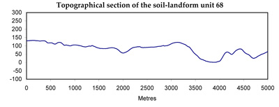
Soil/Landform Unit 68
Landform Unit Description
Page top
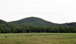 Steeply dissected hills with open forests and woodlands at Mount MacKenzie |
0.44% of CMA region Steeply dissected hills abut either side of the middle and lower reaches of the Gellibrand River. Dissection into Paleogene clay, silt and sand has resulted in steep slopes and narrow drainage lines. The finely textured Paleogene/Neogene sediments outcropping in these areas have resulted in heavier textured soils than those found in the neighbouring Chapple Vale landsystem (soil-landform unit 74). Moisture stress and fertility are not as limiting to plant growth, so open forests of Eucalyptus obliqua and E. baxteri have developed on most sites. Included in the unit are dissected river terraces along the valley of the Gellibrand River and these possess well developed soils with coarse structured subsoils. The higher parts of the landscape may also possess such soils where Kennedys Creek landsystem (soil-landform unit 87) is adjacent, or sandy soils where the Chapple Vale landsystem (soil-landform unit 74) is nearby. Most areas remain forested but areas abutting the floodplains have been cleared to provide winter pastures for dairy cattle. Pines have been established on previously forested land. Sheet erosion and landslips have occurred on many of the steeper slopes where the native vegetation has been removed and the rugged nature of the terrain makes most land uses difficult. | 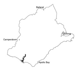 |
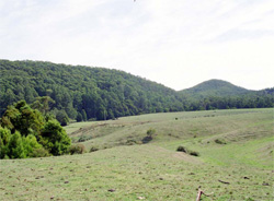 Steep hilss abutting Gellibrand River south of Devondale | 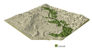 |
 | 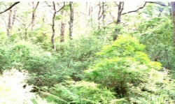 Dense woodland of the valley floor |
Component | 1 | 2 | 3 | 4 | 5 | 6 | 7 |
Proportion of soil-landform unit | 40% | 8% | 9% | 25% | 8% | 7% | 3% |
| CLIMATE Rainfall (mm) | Annual: 950-1100, lowest January (45), highest August (120) | ||||||
| Temperature (oC) | Annual: 13, lowest July (8), highest February (18) | ||||||
| Seasonal growth limitations | Temperature: lesss than 10oC (av.) June-August Precipitation: less than potential evapotranspiration mid November-March | ||||||
| GEOLOGY Age and lithology | Paleogene marine marl, marginal glauconitic sand and gravel; Neogent fluvio-marine sand; minor Cretaceous fluvio-volcanic sediments | ||||||
| Geomorphology | |||||||
| LANDUSE | Uncleared areas: Hardwood forestry for sawlogs, posts and poles; water supply; nature conservation; quarrying of ironstone; softwood forestry Minor cleared areas: Dairy farming; beef cattle grazing | ||||||
| TOPOGRAPHY Landscape | Deeply dissected hills in the middle and lower reaches of the Gellibrand River catchment | ||||||
| Elevation range (m) | 15-180 | ||||||
| Local relief (m) | 100 | ||||||
| Drainage pattern | Dendritic with some radial | ||||||
| Drainage density (km/km2) | 2.6 | ||||||
| Landform | Hills | Valley floors | Terraces | ||||
| Landform element | Slope and crest | Crest and spur (mainly in south) | Crest and slope | Slope and crest | Broad slight depression | - | - |
| Slope and range (%) | 33 (4-63) | 14 (4-19) | 32 (22-45) | 37 (31-49) | 14 (2-21) | 4 (0-7) | 5 (1-9) |
| Slope shape | Convex | Convex | Convex | Convex | Concave | Concave | Convex |
| NATIVE VEGETATION Structure | Open forest | Open forest | Low woodland | Open forest | Low woodland | Woodland | Open forest |
| Dominant species | E. baxteri, E. nitida, E. obliqua, E. radiata | E. obliqua, E. baxteri, E. viminalis, E. ovata | E. baxteri, E. nitida | E. baxteri, E. obliqua | E. nitida, E. baxteri | E. obliqua, E. baxteri | E. obliqua, E. ovata, E. baxteri |
| SOIL Parent material | Clay, silt and sand | Clay, silt and sand | Sand | Clay, silt and sand | Sand, colluvial sand | Plant remains, alluvial sand and clay | Alluvial clay, silt and sand |
| Description (Corangamite Soil Group) | Yellow-brown gradational soils, coarse structure (29) | Grey sand soils (17) | Grey sand soils with hardpans (29) | Black sand soils (8) | |||
| Soil type sites | OTR750 | OTR749 | OTR609, OTR739 | OTR750, OTR733 | |||
| Surface texture | Sandy loam | Fine sandy loam | Loamy sand | Sandy loam | Loamy sand | Loamy sand | Fine sandy loam |
| Permeability | High | Low | Very high | High | Very low | High | Low |
| Depth (m) | >2 | >2 | >2 | >2 | 0.6 | >2 | >2 |
| LAND CHARACTERISTICS, POTENTIAL AND LIMITATIONS | Weakly structured soils on steep slopes are prone to sheet, rill, scour gully erosion and landslips. Low inherent fertility and high permeability lead to nutrient decline. | Dispersible clay subsoils of low permeability are prone to gully erosion | Very low inherent fertility and high permeability lead to nutrient decline. Steeper slopes with compacted soils are prone to sheet, rill and scour gully erosion. | Weakly structured soils on steep slopes are prone to sheet and rill erosion and landslips. Low inherent fertility and high permeability lead to nutrient decline. | High watertables lead to waterlogging and soil compaction. Rapid runoff from adjacent hills leads to flooding and siltation. | Dispersible clay subsoils of low permeability are prone to gully erosion. Low permeabilities and high watertables lead to waterlogging and soil compaction. | |
© State of Victoria (Agriculture Victoria) 1996 - .

This work, Victorian Resources Online, is licensed under a Creative Commons Attribution 4.0 licence. You are free to re-use the work under that licence, on the condition that you credit the State of Victoria (Agriculture Victoria) as author, indicate if changes were made and comply with the other licence terms.
The licence does not apply to ‘branding’ or some ‘images or photographs’ that may be owned by third parties. We ask you to seek prior approval to use images using the VRO feedback form. Access to higher quality images can also be provided on request.
This page was last updated on .