
OTR608
|
| OTR608 | 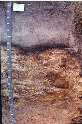 Melacic, Humic/alsilic, Semiaquic, Podosol | |
| Chapple Vale | |||
| Hills | |||
| Palaeogene Pebble Point Formation/Quaternary aeolian deposits | |||
| Hillslope –mid slope | |||
| 12% | |||
| North westerly | |||
Horizon | Depth (cm) | Description | ||
A1 | 0–25 | Very dark brown (10YR2/2); loamy fine sand; weak subangular blocky structure; gradual smooth boundary to: | ||
A2 | 25–60 | Very dark greyish brown (10YR3/2); fine sand; weak subangular blocky structure; occasional quartz gravel; clear wavy boundary to: | ||
B1 | 60–69 | Black (10YR2/1); loamy fine sand; apedal single grain structure; clear wavy boundary to: | ||
B2 | 69–75 | Dark brown (10YR 3/2); sandy clay loam; apedal single grain sturcture; abrupt wavy boundary to: | ||
2Cm | 75+ | Dark yellowish brown (10YR4/4); cemented sand; apedal massive structure; extremely hard. | ||
| Management considerations | ||||
| Deep sandy soils generally have poor plant water/nutrient holding capacity. The sandy nature of the soils make them prone to wind and sheet and rill erosion. Soils may be hydrophobic (in conjunction with organic coatings) when dried out, taking time to reabsorb moisture. These soils do however drain rapidly. The soil profile is consistently acidic (often associated with sandy surfaces due to the lack of base minerals) and may or may not have organic matter (humose or peaty surfaces). This restricts the uptake of certain nutrients as well as intolerance for some plant species (due in part to the increasing mobilisation of aluminium and manganese). Deficiencies of calcium, potassium and molybdenum are likely. Coffee rock is a pan of variable strength that is found beneath 75cm in these soils (Podosols) where sesquioxides (iron and aluminium) and organic matter have cemented soil material. Where this is only weakly developed then it is called a fragipan. This is often a restriction for root development by limiting water and gas movement. This may also have an influence on subsurface water movement such as lateral flow. | ||||
Analytical data
Site OTR608 | Sample depth | pH | EC | NaCl | Ex Ca | Ex Mg | Ex K | Ex Na | Ex Al | Ex acidity | FC (-10kPa) | PWP (-150kPa) | KS | FS | Z | C | |
Horizon | cm | H2O | CaCl2 | dS/m | % | cmolc/kg | cmolc/kg | cmolc/kg | cmolc/kg | mg/kg | cmolc/kg | % | % | % | % | % | % |
A1 | 0-10 | 4.6 | N/R | 0.058 | 0.006 | 0.5 | 0.7 | 0.2 | 0.3 | N/R | N/R | N/R | N/R | 70 | 10 | 4 | 6 |
A1 | 10-20 | 4.5 | N/R | 0.041 | 0.004 | 0.3 | 0.5 | 0.07 | 0.13 | N/R | N/R | N/R | N/R | 78 | 10 | 4 | 9 |
A2 | 30-60 | 4.6 | N/R | 0.018 | 0.001 | 0.08 | 0.14 | <D.01 | 0.04 | N/R | N/R | N/R | N/R | 78 | 15 | 4 | 2 |
B1 | 60-69 | 4.3 | N/R | 0.047 | 0.004 | 0.05 | 0.17 | 0.03 | 0.22 | N/R | N/R | N/R | N/R | 70 | 13 | 3 | 9 |
B2 | 69-75 | 4.2 | N/R | 0.048 | 0.004 | 0.01 | 0.02 | 0.01 | 0.04 | N/R | N/R | N/R | N/R | 62 | 9 | 6 | 17 |
11Cm | 90-120 | 4.8 | N/R | 0.015 | 0.001 | 0.01 | 0.05 | 0.02 | 0.10 | N/R | N/R | N/R | N/R | 72 | 20 | 2 | 3 |
© State of Victoria (Agriculture Victoria) 1996 - .

This work, Victorian Resources Online, is licensed under a Creative Commons Attribution 4.0 licence. You are free to re-use the work under that licence, on the condition that you credit the State of Victoria (Agriculture Victoria) as author, indicate if changes were made and comply with the other licence terms.
The licence does not apply to ‘branding’ or some ‘images or photographs’ that may be owned by third parties. We ask you to seek prior approval to use images using the VRO feedback form. Access to higher quality images can also be provided on request.
This page was last updated on .