
3.2.2 Dissected upland ranges of the Southern Uplands
|
The Barrabool Hills comprises a tilt-block of Cretaceous Otway Group sandstones and mudstones rising from approximately 20 m elevation to a maximum of 211 m along the northern edge (at Bayview). They are bounded to the north by the Barrabool Fault and dissected by tributaries of the Barwon River on the north and east of the block. Landforms are characteristically rounded hills separated by broad valleys. Drainage is weakly rectilinear, favouring south east and north-east directions for the tributaries of the Barwon River (which bounds the northern edge) and the Waurn Ponds Creek (which drains the southern portion of the block). | 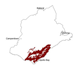 |
Soil-landform unit | Original unit ID | Unit description | Area (km2) |
| Bunker Hill L.S. | Deeply dissected hills (abutting Gellibrand River) | 33 | |
| Mount MacKenzie L.S. | Deeply dissected hills (Gellibrand River Valley) | 59 | |
| Bald Hills L.S. | Deeply dissected hills (Northwest of Anglesea) | 90 | |
| 219/Barabool L.S. | Rolling hills (Barrabool Hills) | 92 | |
| Moggs Creek L.S. | Deeply dissected hills (Aireys Inlet) | 31 | |
| Junction Track L.S. | Dissected hills with broad cappings | 40 | |
| Pennyroyal L.S. | Steep rolling hills | 110 | |
| Chapple Vale L.S. | Dissected hills | 106 | |
| Hordern Vale L.S. | Undulating coastal plain (Cape Otway) | 26 | |
| Porcupine Creek L.S. | Undulating plain | 66 |
© State of Victoria (Agriculture Victoria) 1996 - .

This work, Victorian Resources Online, is licensed under a Creative Commons Attribution 4.0 licence. You are free to re-use the work under that licence, on the condition that you credit the State of Victoria (Agriculture Victoria) as author, indicate if changes were made and comply with the other licence terms.
The licence does not apply to ‘branding’ or some ‘images or photographs’ that may be owned by third parties. We ask you to seek prior approval to use images using the VRO feedback form. Access to higher quality images can also be provided on request.
This page was last updated on .