
OTR741
|
| OTR741 | 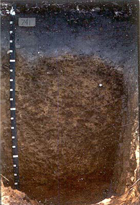 Melacic, Mesotrophic, Brown Kandosol | |
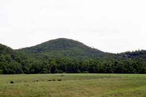
| Mount Mackenzie | |||
| Hills | |||
| Palaeogene Pebble Point Formation, sand and clay | |||
| Mid slope | |||
| 52% | |||
| South-easterly | |||
Horizon | Depth (cm) | Description | ||
A11 | 0–15 | Black (10YR2/1); sandy loam; apedal single grain structure; clear smooth boundary to: | ||
A12 | 15–37 | Black (10YR2/ 1); loamy sand; apedal single grain structure; clear wavy boundary to: | ||
A2 | 37–47 | Dark yellowish brown (10YR4/4 moist); light grey (10YR7/1 dry); sand; apedal single grain structure; broken horizon; abrupt boundary to: | ||
B21 | 47–90 | Brown (7.5YR4/4) with some brownish yellow (10YR6/6) mottles; clayey sand; ironstone gravel and angular fragments common; weak very fine (2 mm) subangular blocky structure; diffuse smooth boundary to: | ||
B22 | 90–180 | Brown (7.5YR4/4) with some brownish yellow (10YR6/6) mottles; light sandy clay loam; weak subangular blocky structure; ironstone common; clear wavy boundary to: | ||
C | 180+ | Yellowish red (5YR4/8); light sandy clay loam; apedal massive ped structure; broken horizon; abrupt boundary to: | ||
| Management considerations | ||||
| The gradational nature of these soils provides few physical limitations to water and gas movement through the profile. The agricultural potential of the soil is dependent however on any chemical or depth restrictions. The sandy topsoil generally indicates a poor plant water/nutrient holding capacity and due to the low level of bonding between soil particles, are prone to wind, and sheet and rill erosion (depending on organic matter content and vegetative cover). The topsoil is hydrophobic (in conjunction with organic coatings) when dry, taking time to reabsorb moisture. Sporadic bleaching of the A2 horizon indicates restricted drainage, and poor soil structure (often massive). The low organic matter content of this horizon results in low nutrient and water holding capacity. These bleached horizons may act as conduit for subsurface flow, particularly on sloping ground. Acidic topsoil (4.5–4.7) restricts the uptake of certain nutrients as well as intolerance for some plant species (due in part to the increasing mobilisation of aluminium and manganese). Mottling of the subsoil (brownish yellow) is an indication of periodic waterlogging. | ||||
Analytical data
Site OTR741 | Sample depth | pH | EC | NaCl | Ex Ca | Ex Mg | Ex K | Ex Na | Ex Al | Ex acidity | FC (-10kPa) | PWP (-150kPa) | KS | FS | Z | C | |
Horizon | cm | H2O | CaCl2 | dS/m | % | cmolc/kg | cmolc/kg | cmolc/kg | cmolc/kg | mg/kg | cmolc/kg | % | % | % | % | % | % |
A11 | 0-10 | 4.7 | N/R | 0.089 | 0.007 | 1.5 | 1.5 | 0.4 | 0.3 | N/R | N/R | N/R | N/R | 8 | 71 | 4 | 8 |
A11 | 10-15 | 4.5 | N/R | 0.082 | 0.007 | N/R | N/R | N/R | N/R | N/R | N/R | N/R | N/R | N/R | N/R | N/R | N/R |
A12 | 15-20 | 4.5 | N/R | 0.051 | 0.005 | 0.1 | 0.3 | 0.2 | 0.2 | N/R | N/R | N/R | N/R | 11 | 76 | 5 | 5 |
A12 | 20-30 | 4.6 | N/R | 0.040 | 0.005 | N/R | N/R | N/R | N/R | N/R | N/R | N/R | N/R | N/R | N/R | N/R | N/R |
A2 | 37-47 | 5.2 | N/R | 0.024 | 0.003 | 0.2 | 0.4 | 0.03 | 0.09 | N/R | N/R | N/R | N/R | 11 | 78 | 6 | 5 |
B21 | 60-90 | 5.9 | N/R | 0.049 | 0.005 | 0.2 | 0.6 | 0.2 | 0.2 | N/R | N/R | N/R | N/R | 22 | 59 | 6 | 13 |
B22 | 120-150 | 5.8 | N/R | 0.060 | 0.006 | 0.4 | 0.9 | 0.1 | 0.3 | N/R | N/R | N/R | N/R | 23 | 58 | 6 | 14 |
C | 180-210 | 5.5 | N/R | 0.085 | 0.013 | 0.3 | 1.1 | 0.1 | 0.5 | N/R | N/R | N/R | N/R | 43 | 36 | 4 | 16 |
© State of Victoria (Agriculture Victoria) 1996 - .

This work, Victorian Resources Online, is licensed under a Creative Commons Attribution 4.0 licence. You are free to re-use the work under that licence, on the condition that you credit the State of Victoria (Agriculture Victoria) as author, indicate if changes were made and comply with the other licence terms.
The licence does not apply to ‘branding’ or some ‘images or photographs’ that may be owned by third parties. We ask you to seek prior approval to use images using the VRO feedback form. Access to higher quality images can also be provided on request.
This page was last updated on .