
Soil/Landform Unit 47
Landform Unit Description
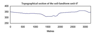
Page top
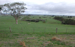 Undulating basaltic rises and plains near Scotchmans Lead |
0.23% of CMA region This unit is part of the dissected uplands associated with volcanic landforms of the Western Uplands. This unit of two occurrences of undulating rises and plains is predominantly basaltic terrain with some older sedimentary terrain and valley deposits. This unit occurs as narrow (flow) units near Linton and Buninyong surrounded by sedimentary terrain (Units 2, 23 and 4). The basaltic rises have red friable gradational (earth) soils (Ferrosols), which are used for intensive cropping (potatoes). The older sedimentary plains and valleys are used for grazing. The red friable soils are productive with high natural nutrient status and good drainage despite high clay contents, but are subject to compaction and structure decline after constant use when wet. The lower slopes and sedimentary plains have brown texture contrast soils (Sodosols) with hardsetting surfaces and sodic subsoils, and are subject to sheet, rill and gully erosion as well as compaction. | 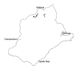 |
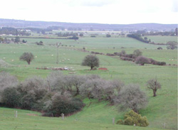 View west of the undulating plain of this unit | 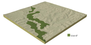 |
|
Component | 1 | 2 | 3 | 4 | 5 | 6 |
Proportion of soil-landform unit | 11% | 11% | 11% | 23% | 23% | 21% |
| CLIMATE Rainfall (mm) | Annual: 690 | |||||
| Temperature (oC) | Minimum 7, Maximum 18 | |||||
| Precipitation less than potential evapotranspiration | October-March | |||||
| GEOLOGY Age and lithology | Pleistocene basalt | Ordovician slate and sandstone | Pleistocene basalt | Quaternary river deposits (gravels, sands and clays) | ||
| Geomorphology | ||||||
| LANDUSE | Uncleared: Nature conservation Cleared: Cropping (potatoes); sheep and beef cattle grazing | |||||
| TOPOGRAPHY Landscape | Undulating rises and plains | |||||
| Elevation range (m) | 252-552 | |||||
| Local relief (m) | 60 | |||||
| Drainage pattern | Dendritic | |||||
| Drainage density (km/km2) | 2.3 | |||||
| Landform | Undulating rises | Rolling plains | Gently undulating plains | Terrace and depressions | ||
| Landform element | Crests and upper slopes | Mid slope | Lower slope and depressions | Long gentle slopes | Long gentle upper slopes | |
| Slope and range (%) | 1 (1-6) | 3 (2-7) | 1 (1-2) | 5 (3-9) | 1 (1-3) | 1 (1-2) |
| Slope shape | Convex | Straight | Concave | Straight | Straight | Straight |
| NATIVE VEGETATION Ecological Vegetation Class | Plains Grassy Woodland 94.2%), Heathy Dry Forest (2.7%), Valley Grassy Forest (0.4%) | |||||
| Dominant species | E. viminalis, E. radiata, E. obliqua | E. viminalis, E. radiata, E. obliqua | E. viminalis, E. radiata, E. obliqua | E. obliqua, E. viminalis | E. ovata, E. viminalis, E. rubida, E. obliqua | E. viminalis, E. radiata |
| SOIL Parent material | In situ weathered basalt | In situ weathered basalt | In situ weathered basalt | In situe weathered basalt | In situ weathered basalt | Unconsolidated gravel, sand, silt and clay |
| Description (Corangamite Soil Group) | Red gradational soil, fine structure (40) | Dark red gradational soil, fine structure (40) | Mottled brown, grey or yellow sodic texture contrast soil, coarse structure (36) | Red mottled brown, grey or yellow texture contrast soil (25) | Mottled brown, grey or yellow, grey sodic texture contrast soil, coarse structure (26) | Dark brown soil - variable (34) |
| Soil type sites | BD10, CRLA54, CLRA58 | |||||
| Surface texture | Clay loam | Loam | Clay loam | Loamy clay | Clay loam | Fine sandy clay loam |
| Permeability | High | High | Moderate to low | Moderate to low | Moderate to low | Moderate to low |
| Depth (m) | 2 | 1.5 | 1.5 | 1 | 1.5 | 2 |
| LAND CHARACTERISTICS, POTENTIAL AND LIMITATIONS | Exposed slopes lead to overland flow and sheet erosion. Leaching and nutrient decline also commonly occur. | Hardsetting surface soils can lead to compaction and are subject to overland flow and sheet erosion on moderate slopes. Leaching and nutrient decline also commonly occur. | Hardsetting surface soils can lead to compaction, while low permeability and waterlogging are features of these soils. | Hardsetting surface soils can lead to compaction and are subject to overland flow, gully, sheet and rill erosion on moderate slopes. Leaching of nutrients also occur on these soils. | Hardsetting surface soils can lead to compaction and slowly permeable subsoils lead to periodic waterlogging. Overland flow and sheet erosion may also occur on these soils. | Low-lying areas receiving drainage leads to waterlogging of soils. Overland flow can lead to streambank erosion and gully erosion. |
© State of Victoria (Agriculture Victoria) 1996 - .

This work, Victorian Resources Online, is licensed under a Creative Commons Attribution 4.0 licence. You are free to re-use the work under that licence, on the condition that you credit the State of Victoria (Agriculture Victoria) as author, indicate if changes were made and comply with the other licence terms.
The licence does not apply to ‘branding’ or some ‘images or photographs’ that may be owned by third parties. We ask you to seek prior approval to use images using the VRO feedback form. Access to higher quality images can also be provided on request.
This page was last updated on .