
SFS6
|
| SFS6 | 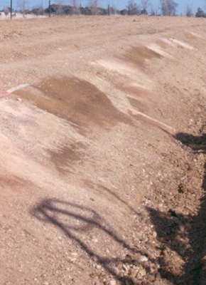 Manganic, Mottled-Mesonatric, Yellow Sodosol (View in surface drain, depth 1.2 metre) | |
| Learmonth Road: Cardigan | |||
| Gently undulating plain | |||
| Quaternary Volcanics: basalt | |||
| Plain | |||
| <1% | |||
| South west | |||
Horizon | Depth (cm) | Description | ||
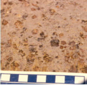
Ap | 0– 15 | Brown (10YR4/3); fine sandy clay loam; weak surface seal (powdery); apedal; large (>10%) amount of coarse (5–20 mm) buckshot gravel on the ground surface, <10% magnetic; firm consistence; pH 5.7; clear boundary to: | ||
A2c | 15–40/45 | Pale brown (10YR6/3 moist), conspicuously bleached (10YR7/3 dry); fine sandy loam, gravelly; apedal structure; abundant (50%), medium (5–25 mm) buckshot gravel with black manganiferous centres, becoming cemented at base of horizon; buckshot can be broken with some finger force; pH 5.4; clear boundary to: | ||
B21c | 45–60 | Gravelly clay loam with abundant (80%) coarse to very coarse (10–40 mm) manganiferous buckshot/ironstone gravel; pH 6.7; abrupt boundary to: | ||
B22tg | 60–120 + | Light yellowish brown (2.5Y6/4 moist); light medium clay; with prominent, small tending to linear, dark red (2.5YR4/8) mottles with brownish yellow (10YR6/8) fringes; 30–50%, fine (5-10 mm) polyhedral structure; pH 7.2. | ||
| Management considerations | ||||
| The soil at this site is highly variable with strongly developed gilgai features. The topsoil is susceptible to waterlogging, wind and water erosion and compaction. The high gravel content limits water availability for plants and the sodic clay subsoil restricts drainage. Acidity should be raised for crop and pasture production. Organic carbon of the topsoil (1.3%) represents the lowest recorded from the south west cropping sites, this should be increased to improve structure and protect the soil from erosion. | ||||
Analytical data
Site SFS6 | Sample depth | pH | EC | NaCl | Ex Ca | Ex Mg | Ex K | Ex Na | Ex Al | Ex acidity | FC (-10kPa) | PWP (-150kPa) | KS | FS | Z | C | |
Horizon | cm | H2O | CaCl2 | dS/m | % | cmolc/kg | cmolc/kg | cmolc/kg | cmolc/kg | mg/kg | cmolc/kg | % | % | % | % | % | % |
Ap | 0–10 | 5.7 | 4.9 | 0.09 | N/R | 3.1 | 0.81 | 0.38 | 0.14 | <10 | 6.9 | 29 | 7 | 4.4 | 45.8 | 24.5 | 19 |
A2 | 20–35 | 5.4 | 4.6 | <0.05 | N/R | 1.9 | 0.51 | 0.17 | 0.08 | 18 | 6.5 | 27.9 | 18.5 | 7.8 | 46.1 | 25 | 15.5 |
B21c | 45–60 | 6.7 | 5.7 | 0.05 | N/R | 2.1 | 2.6 | 0.17 | 0.51 | N/R | 6.3 | 27.3 | 9.9 | 11.4 | 38.9 | 20 | 27 |
B22tg | 65–85 | 7.2 | 6.3 | 0.17 | N/R | 3.9 | 10 | 0.35 | 2.6 | N/R | 9.4 | 46 | 25.1 | 2.8 | 16.3 | 11.5 | 65.5 |
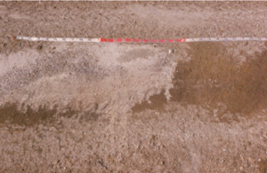
View of “hollow” and “puff” gilgai features in drain excavation
Depth to clay, presence of A2 and distribution of buckshot are all highly variable in this soil
© State of Victoria (Agriculture Victoria) 1996 - .

This work, Victorian Resources Online, is licensed under a Creative Commons Attribution 4.0 licence. You are free to re-use the work under that licence, on the condition that you credit the State of Victoria (Agriculture Victoria) as author, indicate if changes were made and comply with the other licence terms.
The licence does not apply to ‘branding’ or some ‘images or photographs’ that may be owned by third parties. We ask you to seek prior approval to use images using the VRO feedback form. Access to higher quality images can also be provided on request.
This page was last updated on .