
Soil/Landform Unit 23
Landform Unit Description
Page top
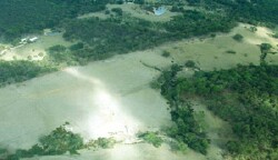
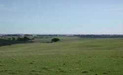 Broad gentle crests north-east of Rokewood Junction. Soils of these slopes tend to be hardsetting and are vulnerable to erosion |
1.93% of CMA region This land unit is situated in the dissected uplands (Midlands) within the Western Uplands and consists of gently undulating plains. The broad rounded topography is in association with a Neogene capping of sands and other unconsolidated sediments. Vegetation communities include Heathy Dry Forests, Grassy Dry Forest, Creekline Herbrich Woodland and Valley Grassy Forest. This unit is predominantly a single mass with a few outliers situated to the south of the exposed Palaeozoic sediment terrain, capping more of this terrain with poorly defined coarse drainage falling to the south. This broad crests and plains unit has been divided into components based on drainage (as a result of differing soils and parent material). The basalts form a significant border. The soils generally have a significant sand component, with clay subsoils or a clay base at depth, and are strongly acidic in the surface and subsurface soil. These soils have a low nutrient holding capacity with some having sodic subsoils, particularly in the poorer drained areas. | 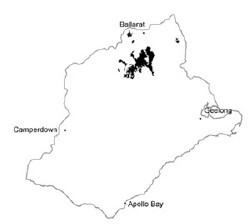 |
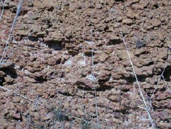 Ferricrete of a cutting at Corindhap | 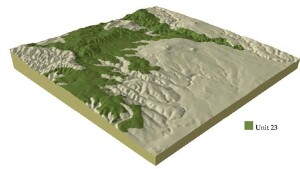 |
|  Deep dissection of lower Palaeozoic sediments is common within this landscape |
Component | 1 | 2 | 3 | 4 |
Proportion of soil-landform unit | 70% | 2% | 15% | 13% |
| CLIMATE Rainfall (mm) | Annual: 720 | |||
| Temperature (oC) | Minimum 7, Maximum 18 | |||
| Precipitation less than potential evapotranspiration | October-March | |||
| GEOLOGY Age and lithology | ||||
| Geomorphology | ||||
| LANDUSE | Uncleared: Nature conservation; sport and recreation; residential development; softwood plantations Cleared: Softwood plantation; residential development; sheep and beef cattle grazing | |||
| TOPOGRAPHY Landscape | Undulating plains and rises associated with Ordovician hills | |||
| Elevation range (m) | 200-560 | |||
| Local relief (m) | 40 | |||
| Drainage pattern | Dendritic | |||
| Drainage density (km/km2) | 2.3 | |||
| Landform | Undulating plains | |||
| Landform element | Well drained non-sandy areas | Patches of deep sandy soil | Poorly drained non-sandy areas | Low-lying areas |
| Slope and range (%) | 2 (1-3) | 2 (1-3) | 0 (0-2) | 1 (1-3) |
| Slope shape | Convex | Convex | Flat | Concave |
| NATIVE VEGETATION Ecological Vegetation Class | Heathy Dry Forest (26.9%), Grassy Dry Forest (5.7%), Creekline Herb-rich Woodland (2.5%), Valley Grassy Forest (15%) | |||
| Dominant species | Callitris columellaris, E. viminalis, E. obliqua, E. radiata, E. rubida, E. ovata, E. pauciflora | Pteridium esculentum, E. viminalis | E. ovata | E. ovata |
| SOIL Parent material | Unconsolidated gravel, sand and clay | Unconsolidated sand | Unconsolidated gravel, sand and clay | Unconsolidated gravel, sand and clay |
| Description (Corangamite Soil Group) | Bronw, grey or yellow sodic texture contrast soil, coarse structure (14) | Mottled brown, grey or yellow texture contrast soil (13) | ||
| Soil type sites | ||||
| Surface texture | Sandy clay loam to loamy sand | Sand | Clay loam | Clay loam, sandy clay loam |
| Permeability | Moderate | High | Low | Moderate |
| Depth (m) | 2 | 2 | 2 | 2 |
| LAND CHARACTERISTICS, POTENTIAL AND LIMITATIONS | Hardsetting surfaces and low permeability leads to overland flow. This flow often creates sheet and rill erosion with major rainfall events. Gully erosion and leaching of salts also occur. Surface compaction can benefit from controlled traffic. | Low water and nutrient holding capacities lead to leaching and fertility decline. | Hardsetting surfaces and low permeability leads to overland flow. This flow often creates sheet and rill erosion with major rainfall events. Gully erosion and leaching of salts also occur. Surface compaction can benefit from controlled traffic. | Hardsetting surfaces and low permeability leads to overland flow. This flow often creates sheet and rill erosion with major rainfall events. Gully erosion and leaching of salts also occur. |
© State of Victoria (Agriculture Victoria) 1996 - .

This work, Victorian Resources Online, is licensed under a Creative Commons Attribution 4.0 licence. You are free to re-use the work under that licence, on the condition that you credit the State of Victoria (Agriculture Victoria) as author, indicate if changes were made and comply with the other licence terms.
The licence does not apply to ‘branding’ or some ‘images or photographs’ that may be owned by third parties. We ask you to seek prior approval to use images using the VRO feedback form. Access to higher quality images can also be provided on request.
This page was last updated on .