
SW5
|
| SW5 | 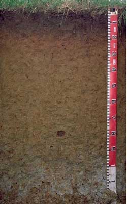 Mottled-Sodic, Eutrophic, Brown DERMOSOL/ ferric kaolinitic clay | |
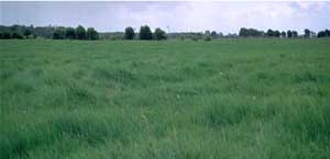
| Moreys Road, Ayrford, Timboon District, south-west Victoria | |||
| Plain | |||
| Neogene Hanson Plain Sand | |||
| Flat | |||
| 0 | |||
| - | |||
Horizon | Depth (cm) | Description | ||
A11 | 0-15 | Brown (10YR4/3); very fine sandy clay loam; weak to moderate medium blocky structure; weak consistence (moist); few (2–5%) ferromanganiferous nodules (2–4mm); pH 5.9; abrupt boundary to: | ||
B21 | 15-25 | Yellowish red (5YR5/6); light clay (subplastic); moderate medium blocky structure; weak consistence (moist); few (2-5%) ferromanganiferous nodules (2–10mm); pH 6.0; clear boundary to: | ||
B22 | 25-50 | Yellowish brown (10YR5/6) with strong brown (7.5YR5/6) mottles; light clay (subplastic); moderate medium blocky structure; weak consistence (moderately moist); few (5%) ferromanganiferous concretions (2–10mm); pH 6.0; clear boundary to: | ||
B23 | 50-75 | Yellowish brown (10YR5/6) with strong brown (7.5YR5/6) mottles; light medium clay (subplastic); strong coarse polyhedral parting to fine polyhedral structure; pH 6.8; boundary to: | ||
B24 | 75-95 | Yellowish brown (10YR5/6); light clay (subplastic); strong medium–coarse polyhedral parting to strong fine polyhedral structure; very firm consistence (moderately moist); common (20%) ferruginous concretions (2– 8cm); pH 5.9; boundary to: | ||
B3 | 95+ | Light grey (2.5Y7/0) with brownish yellow (10YR6/6) mottles; light clay (subplastic); strong consistence (dry); many (50%) ferruginous concretions (2–10cm); pH 5.6. | ||
| Management considerations | ||||
| A lack of strong texture contrast between surface (A) horizon and subsoil (B21) horizon is a key feature of gradational soil types as the clay increases gradually down the profile to the extent that the deep subsoil formed from deeply weathered Neogene sediments exhibits a very high clay content. The surface soil is moderately acid, as is the upper subsoil whereas the deeper subsoil (from 50 cm depth) becomes slightly to moderately acid. The salinity rating is very low throughout most of the profile and becomes low in the deeper subsoil. Plant available water capacity (PAWC) is considered to be moderate (estimated at 120 mm) for the top metre of the soil profile. The surface soil has a high organic matter content ( %OC) which is important to promote aggregation of soils such as these with high fine sand and silt contents. The nutrient status of the surface soil is moderate (based on the sum of the exchangeable basic cations). The subplastic properties of the subsoil may lead to problems with sealing of earth dams. Sealing can be improved by compaction at the optimum water content and treatment with sodium tri-polyphosphate or addition of bentonite (Rolfe 1989). | ||||
Analytical data
Site SW5 | Sample depth | pH | EC | NaCl | Ex Ca | Ex Mg | Ex K | Ex Na | Ex Al | Ex acidity | FC (-10kPa) | PWP (-150kPa) | KS | FS | Z | C | |
Horizon | cm | H2O | CaCl2 | dS/m | % | cmolc/kg | cmolc/kg | cmolc/kg | cmolc/kg | mg/kg | cmolc/kg | % | % | % | % | % | % |
A11 | 0-15 | 5.9 | 5.4 | 0.19 | N/R | 9.4 | 1.7 | 0.64 | 0.70 | N/R | N/R | N/R | 19.0 | 9.1 | 37.0 | 11.5 | 29.0 |
B21 | 15-25 | 6.0 | 5.7 | 0.22 | N/R | 5.4 | 1.3 | 0.33 | 0.47 | N/R | N/R | N/R | 17.0 | 7.6 | 36.0 | 13.0 | 41.0 |
B22 | 25-30 | 6 | 5.8 | 0.17 | N/R | 4.1 | 3.4 | 0.21 | 0.65 | N/R | N/R | N/R | 19.4 | 8.0 | 30.7 | 9.0 | 52.0 |
B23 | 50-75 | 6.8 | 6.3 | 0.16 | N/R | 3.1 | 6.0 | 0.20 | 0.87 | N/R | N/R | N/R | 27.5 | 4.8 | 16.5 | 6.0 | 74.0 |
B24 | 75-95 | 5.9 | 5.4 | 0.61 | <0.05 | 3.5 | 5.2 | 0.15 | 0.84 | N/R | N/R | N/R | 26.0 | 9.2 | 17.4 | 5.0 | 71.5 |
B3 | 95+ | 5.6 | 4.9 | 0.32 | <0.05 | 4.3 | 4.1 | 0.14 | 0.94 | N/R | N/R | N/R | 23.0 | 16.6 | 19.1 | 4.0 | 62.0 |
© State of Victoria (Agriculture Victoria) 1996 - .

This work, Victorian Resources Online, is licensed under a Creative Commons Attribution 4.0 licence. You are free to re-use the work under that licence, on the condition that you credit the State of Victoria (Agriculture Victoria) as author, indicate if changes were made and comply with the other licence terms.
The licence does not apply to ‘branding’ or some ‘images or photographs’ that may be owned by third parties. We ask you to seek prior approval to use images using the VRO feedback form. Access to higher quality images can also be provided on request.
This page was last updated on .