
OTR734
|
| OTR734 | 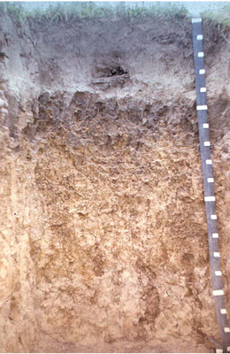 Melanic, Mottled-Mesonatric, Brown Sodosol | |
| Whoorel | |||
| Undulating rises | |||
| Quaternary alluvium | |||
| Mid slope | |||
| 12% | |||
| South-westerly | |||
Horizon | Depth (cm) | Description | ||
A1 | 0–27 | Very dark brown (10YR2/2); fine sandy loam; weak subangular blocky structure; diffuse boundary to: | ||
A2 | 27–42 | Brown (l 0YR4/3 moist); fine sandy loam; light grey (10YR7/2 dry); apedal single grain structure; some ironstone gravel; abrupt wavy boundary to: | ||
B2 | 42–90 | Dark greyish brown (10YR4/2) with some yellow (10YR7/6) mottles; heavy clay; strong very fine (4 mm) angular blocky structure; diffuse wavy boundary to: | ||
C | 90+ | Light grey (2.5YR7/3) with yellow (2.5YR7/6) mottles; light clay; weak angular blocky structure (2 mm). | ||
| Management considerations | ||||
| The acidic upper horizons restrict the uptake of certain nutrients as well as intolerance for some plant species (due in part to the increasing mobilisation of aluminium and manganese). The surface horizon (A1) is hydrophobic, tending not to absorb water. Strong texture contrast between the surface soil and the subsoil can have a major effect by reducing and/or redirecting the internal drainage and restricting root growth beyond the upper horizons. Ferruginous and Ferromanganiferous nodules (sometimes known as ironstone gravel) can restrict root penetration and limit available water holding capacity where there are sufficient amounts. They along with mottled subsoils provide an indication of a periodic waterlogging. Subsoil has prominent columnar structure (10 cm long) with roots growing between peds. The C horizon has some white specs of kaolin as soft accumulations in root channels. At 15 cm there was 15% charcoal. These soils usually have medium to heavy textures and may be sodic (and therefore dispersive), often with low liquid limits (change from solid, plastic to liquid quickly). Dispersion (and subsequent clogging of pores), restricting water and gas movement through the subsoil may occur. These soils are hardsetting and have limited opportunity for cultivation without further damage to soil structure. Alkaline subsoils are associated with a high nutrient capacity but result in an imbalance in nutrient availability (may be restrictive to certain plant species (eg. potatoes). | ||||
Analytical data
Site OTR734 | Sample depth | pH | EC | NaCl | Ex Ca | Ex Mg | Ex K | Ex Na | Ex Al | Ex acidity | FC (-10kPa) | PWP (-150kPa) | KS | FS | Z | C | |
Horizon | cm | H2O | CaCl2 | dS/m | % | cmolc/kg | cmolc/kg | cmolc/kg | cmolc/kg | mg/kg | cmolc/kg | % | % | % | % | % | % |
A1 | 0-10 | 5.1 | N/R | 0.050 | 0.004 | 1.2 | 1.3 | 0.9 | 0.1 | N/R | N/R | N/R | N/R | N/R | N/R | N/R | N/R |
A1 | 10-20 | 5.3 | N/R | 0.042 | 0.004 | 1.3 | 1.4 | 0.3 | 0.2 | N/R | N/R | N/R | N/R | 9 | 70 | 8 | 10 |
A1 | 20-27 | 5.6 | N/R | 0.035 | 0.003 | N/R | N/R | N/R | N/R | N/R | N/R | N/R | N/R | N/R | N/R | N/R | N/R |
A2 | 30-42 | 5.8 | N/R | 0.024 | 0.003 | 1.0 | 0.9 | 0.2 | 0.0 | N/R | N/R | N/R | N/R | 9 | 74 | 11 | 4 |
B2 | 60-90 | 7.7 | N/R | 0.280 | 0.027 | 2.8 | 11.9 | 0.2 | 4.4 | N/R | N/R | N/R | N/R | 1 | 63 | 6 | 27 |
C | 120-140 | 8.1 | N/R | 0.470 | 0.051 | 3.2 | 14.8 | 0.4 | 7.0 | N/R | N/R | N/R | N/R | 0.4 | 56 | 11 | 32 |
C | 150-180 | 8.0 | N/R | 0.480 | 0.056 | 2.5 | 13.1 | 0.4 | 6.5 | N/R | N/R | N/R | N/R | 0.2 | 62 | 10 | 28 |
© State of Victoria (Agriculture Victoria) 1996 - .

This work, Victorian Resources Online, is licensed under a Creative Commons Attribution 4.0 licence. You are free to re-use the work under that licence, on the condition that you credit the State of Victoria (Agriculture Victoria) as author, indicate if changes were made and comply with the other licence terms.
The licence does not apply to ‘branding’ or some ‘images or photographs’ that may be owned by third parties. We ask you to seek prior approval to use images using the VRO feedback form. Access to higher quality images can also be provided on request.
This page was last updated on .