
3.1 High relief, (moderate elevation, about 250 - 600 m) Otway, Strzelecki and Hoddle Ranges
- 3.1.1 Plateaux and broad ridges (Beech Forest, Wyelangata, Balook)
- 3.1.2 Ranges (Forrest, Barramunga, Poowong, Fish Creek)
- 3.1.3 Basalt residuals (Thorpdale, Nerrim South)
- 3.1.4 Prominent hills (Wilsons Promontory)
3. Southern Uplands (SU)
3.1.1 Plateaux and broad ridges (Beech Forest, Wyelangata, Balook)
3.1.2 Ranges (Forrest, Barramunga, Poowong, Fish Creek)
3.1.3 Basalt residuals (Thorpdale, Nerrim South)
3.1.4 Prominent hills (Wilsons Promontory)
| These comprise the Otway, Strzelecki and Hoddle Ranges and Wilsons Promontory. The Otway, Strzelecki, and Hoddle Ranges have all been a result of significant uplift occurring in the recent geological past along north-easterly trending fault lines. In the Otway Ranges, this has occurred along two reverse faults: the westerly dipping Torquay fault to the east and the Bambra fault to the west (Joyce, Webb et al. in press) with an estimated 175 to 240 m of uplift occurring in the Late Neogene (Sandiford 2003). The Strzelecki and Hoddle Ranges have also resulted from a series of north-easterly trending fault lines and monoclines. Some examples are the Bass fault near Loch, the Yarragon monocline south of Yarragon, the Kongwak fault north of the Powlett River, the Budgeree fault south of Churchill and the Yarram monocline west of Yarram. These faults have resulted in a major alteration of the Late Paleogene to Early Neogene stream pattern as evidenced by the presence of their sediments on both the northern and southern flanks. | 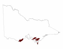 |
The continued uplift of all of these ranges is partially responsible for the moderate to steep slopes and the incision of steep river valleys. The underlying lithology is comprised of sedimentary rocks of Lower Cretaceous Otway Group west of Port Phillip Bay and the Lower Cretaceous Strzelecki Group east of the Bay. Palaeogene basalts (see Section 3.1.4) occur as a cap on the northern part of the Strzelecki Ranges around Thorpdale and a discontinuous cap on and fringing the Hoddle Ranges.
Within the Southern Uplands of high relief a number of separate landforms may be recognised. These are: plateau and broad ridges (eg. Beech Forest, Wyelangata and Balook, see 3.1.1); ranges (eg. Forrest, Barramunga, Poowong and Mirboo East, see 3.1.2) and terraces and basalt residuals (Thorpdale and Nerrim South, see 3.1.3). Wilson’s Promontory (see 3.1.4) consists of granitic mountains and hills and is the most southerly extent of the Australian mainland.
Related information on VRO
- Land Capability Studies in the Central Gippsland Region - Preliminary Report (L D Russell 1980)
- A Classification of Lands at Wilson's Promontory - Second Edition, Technical Report No. 43 (G T Sibley and D Rees 1999)
- Study of the Land in the Otway Ranges and Adjacent Plains (T Pitt 1981)
- West Gippsland - Regional Soil/Landform Mapping
© State of Victoria (Agriculture Victoria) 1996 - .

This work, Victorian Resources Online, is licensed under a Creative Commons Attribution 4.0 licence. You are free to re-use the work under that licence, on the condition that you credit the State of Victoria (Agriculture Victoria) as author, indicate if changes were made and comply with the other licence terms.
The licence does not apply to ‘branding’ or some ‘images or photographs’ that may be owned by third parties. We ask you to seek prior approval to use images using the VRO feedback form. Access to higher quality images can also be provided on request.
This page was last updated on .