
3.1.4 Prominent hills (Wilsons Promontory)
3. Southern Uplands (SU)
3.1 High relief, (moderate elevation, about 250 - 600 m) Otway, Strzelecki and Hoddle Ranges
| Wilson’s Promontory consists of granitic mountains and hills and is the most southerly extent of the Australian mainland. The annual rainfall here is over 1 000 mm with much exceeding 1 400 mm. Being a National Park, wide range of native vegetation types occur here including heathlands, heathy woodlands, dry forests and wet forests. Landforms are either related to the granitic outcrops, granitic derived colluvium and alluvium or aeolian and marine deposits in the form of dunefields (relict and recent) and estuaries. Soil types range from shallow stony soils (Rudosols) through to earthy gradational (Dermosols), occasional acidic texture contrast soils (Kurosols) as well as sandy soils (Tenosols). | 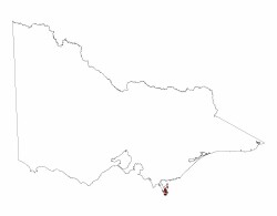 |
© State of Victoria (Agriculture Victoria) 1996 - .

This work, Victorian Resources Online, is licensed under a Creative Commons Attribution 4.0 licence. You are free to re-use the work under that licence, on the condition that you credit the State of Victoria (Agriculture Victoria) as author, indicate if changes were made and comply with the other licence terms.
The licence does not apply to ‘branding’ or some ‘images or photographs’ that may be owned by third parties. We ask you to seek prior approval to use images using the VRO feedback form. Access to higher quality images can also be provided on request.
This page was last updated on .