
Regional Soil/Landform Mapping
Status of Soil/Landform Mapping
A survey of the soils and landforms covering non-public lands throughout the region is currently being completed at 1:100 000 scale and is now being entered onto this website. A number of preliminary reports have been published as part of this survey – including ‘Major Agricultural Soils of the Maffra Region’ (Sargeant and Imhof, 2000). The information provided here can be referenced as: Sargeant, I and Imhof, M. Major Agricultural Soils of West Gippsland - as published on the Victorian Resources Online website.
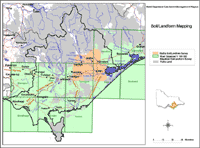 West Gippsland Detailed Soil / Landform Surveys | Mapsheets - (shaded green on map) Foster Mapsheet Moe Mapsheet Sale Mapsheet Stratford Mapsheet Traralgon Mapsheet Warragul Mapsheet Wonthaggi Mapsheet Woolamai Mapsheet Yarram Mapsheet Soils of the Maffra Region - (shaded orange on map) Regional Soil/Landform Mapping Units References |
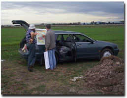 Ian Sargeant discussing soil mapping with a landholder near Sale. |
Access to spatial data
A spatial dataset of Land units of the Gippsland region of Victoria (external link) (DOI 10.4226/92/58e719aeb6e7c) is freely available through the DataVic website.
© State of Victoria (Agriculture Victoria) 1996 - 2025.

This work, Victorian Resources Online, is licensed under a Creative Commons Attribution 4.0 licence. You are free to re-use the work under that licence, on the condition that you credit the State of Victoria (Agriculture Victoria) as author, indicate if changes were made and comply with the other licence terms.
The licence does not apply to ‘branding’ or some ‘images or photographs’ that may be owned by third parties. We ask you to seek prior approval to use images using the VRO feedback form. Access to higher quality images can also be provided on request.
This page was last updated on 24/05/2019.