
3. Southern Uplands (SU)
- 3.1 High relief, (moderate elevation, about 250 - 600 m) Otway, Strzelecki and Hoddle Ranges
- 3.2 Low relief (low elevation, about 100 - 250 m)
- 3.3 Very low relief (very low elevation, generally less than 100 m)
Victoria's Geomorphological Framework (VGF)
3.1 High relief, (moderate elevation, about 250 - 600 m) Otway, Strzelecki and Hoddle Ranges
3.2 Low relief (low elevation, about 100 - 250 m)
3.3 Very low relief (very low elevation, generally less than 100 m)
| West of Port Phillip Bay The southern portion of the Corangamite CMA region is dominated by the Victorian Southern Uplands that form the high relief and moderate elevation (250 – 600 m) Otway Ranges, low relief and low elevation (100 – 250 m) Barrabool Hills, and the very low relief and very low elevation (<100 m) of the Bellarine Peninsula. All three landscapes have formed by the uplift of a structurally controlled block of lithic sedimentary rocks of the Lower Cretaceous Otway Group or Neogene sediments. The Barrabool Hills and Bellarine Peninsula are smaller fault-bounded uplift blocks at lower elevations than the Otway Ranges, and are generally more planar and less deeply dissected. The geological units of the Southern Uplands vary considerably in their degree and depth of weathering. Rocks of the Otway Group (west of Cape Otway) and in the Barrabool Hills are very fractured and bleached compared to the rocks exposed in comparable landscape positions east of Cape Otway. The rocks are mostly made of fragments of volcanic rocks, calcic feldspars and very little quartz. Minerals that make-up the rocks are quickly and easily weathered when exposed to the elements (except quartz), producing a clay-rich soil. The rocks and sediments of the Bellarine Peninsula are much more varied than the Otway Ranges and the Barrabool Hills and comprise mainly basalts of the Older Volcanics (Paleogene) and Early Neogene marine sands. | 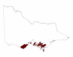 |
East of Port Phillip Bay
The most prominent features of the Southern Uplands of southern West Gippsland are the Strzelecki Ranges in the west, the Hoddle Ranges (south of Morwell) in the east and Wilson’s Promontory in the south. These high relief and moderate elevation (250 – 600m) ranges were also formed by a series of prominent faults that have general north-easterly trend (e.g. Bass and Yarram faults). Wilsons Promontory, which is the most southerly extent of the Australian mainlandconsists of granitic mountains and hills.
Also included in the Southern Uplands are several smaller areas that have been separated into areas of low relief and low elevation (100 – 250 m) (e.g. Red Hill, Drouin) and areas of very low relief and very low elevation (<100m) (e.g. Moorooduc Plains, French Island and Phillip Island). These areas are also defined by north-easterly trending faults (e.g. Selwyn, Tyabb and Heath Hill faults).
It seems probable that the Strzelecki and Hoddle Ranges were initially uplifted in the mid-Cretaceous followed by a period of erosion. There are indications of a major uplift in the Paleogene and there is substantial evidence for continuing tectonic activity throughout the Neogene up to the present throughout the Southern Uplands. Both these ranges were formed by the uplift of a structurally controlled block of lithic sedimentary rocks known as the Lower Cretaceous Strzelecki Group. Most of the rocks exposed within these ranges comprise these Cretaceous sediments but remnants of early to mid-Tertiary (Palaeogene) basalt do occur, e.g. at Balook and Carrajung, with the most extensive area on the northern part of the Strzelecki Ranges around Thorpdale. Basalt remnants also occur on the north-western to north-eastern flanks and the higher parts of the Hoddle Ranges.
The rocks and sediments comprising the areas of low elevation are quite varied and include Cretaceous sediments (Nyora), mid-Tertiary basalts (Warragul, Red Hill) with small areas of Devonian granite (Arthurs Seat and late Tertiary sediments (Gurdies). The very low relief Moorooduc Plains are mainly comprised of Neogene sediments.
Futher reading
Sandiford M. 2003. Geomorphic constraints on the late Neogene tectonics of the Otway Range, Victoria. Australian Journal of Earth Sciences 50, 69-80.
Jenkin J. J. Geological history of the West Gippsland region. Proceedings of the Royal Society of Victoria. 84, 19-28.
Hill S. M. & Joyce E. B. 1995. Granite regolith and landscape evolution of Wilsons Promontory, Victoria. Proceedings of the Royal Society of Victoria. 107, 1-10.
© State of Victoria (Agriculture Victoria) 1996 - .

This work, Victorian Resources Online, is licensed under a Creative Commons Attribution 4.0 licence. You are free to re-use the work under that licence, on the condition that you credit the State of Victoria (Agriculture Victoria) as author, indicate if changes were made and comply with the other licence terms.
The licence does not apply to ‘branding’ or some ‘images or photographs’ that may be owned by third parties. We ask you to seek prior approval to use images using the VRO feedback form. Access to higher quality images can also be provided on request.
This page was last updated on .