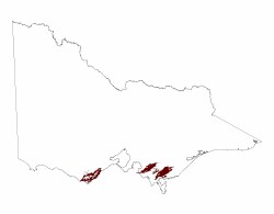
3.1.2 Ranges (Forrest, Barramunga, Poowong, Fish Creek)
3. Southern Uplands (SU)
3.1 High relief, (moderate elevation, about 250 - 600 m) Otway, Strzelecki and Hoddle Ranges
| West of Port Phillip Bay (Forrest, Barramunga) On both sides of the Otway divide rugged topography has developed comprising ridges and spurs separated by deeply dissected steep valleys. The drainage is strongly controlled by the geological structure. Parallel to the south-east coast, the drainage is generally south-east and north-west, whereas west of Mount Sabine, the drainage is generally north and south. The depth of dissection lessens towards the ridge, while the south-eastern flanks of the ranges have developed the steepest topography, probably in response to the fluctuations in sea level over the past million years that have changed the base level of the rivers and streams that drain the landscapes. The fluctuation in sea level and the associated uplift of the Otway Ranges has resulted in the rapid erosional processes that has resulted in numerous large landslides, with probably more activity in the past 6 000 years since the slight drop in stream base levels (renewed erosion) and warmer (and therefore wetter) climates have prevailed (Dahlhaus & Miner 2002). |  |
The streams flowing south are mostly short and enter the sea directly, whereas those to the north join the larger Barwon and Gellibrand river systems. The long profiles of the southerly streams are mostly steep and stepped, each step representing a waterfall over a thicker, more resistant bed of sandstone. The steps may also represent knickpoints migrating upstream, corresponding to coastal terraces that are poorly developed in some areas, such as around Apollo Bay.
The Otways coast largely comprises spectacular cliffs and shore platforms, actively incised in the Early Cretaceous sandstones and shales by the swells and storms of the Southern Ocean coming predominantly from the west. The coastline has been eroded within the past 6 000 years, and the resulting recession has been estimated as 105 m on mudstones and 53 m on sandstones along the Otway coast (Bird 2002).
Soils vary from shallow stony loams (Rudosols) in the steep and actively eroding parts of the landscapes, to brown and yellow gradational soils (Dermosols) with associated colluvium on the slopes. Thick deposits of colluvium and landslide debris are common. Annual rainfall is high throughout the area, with most areas exceeding 1 000 mm. Around the Beech Forest area the annual rainfall exceeds 1 400 mm. Prior to European settlement the vegetation in the Otway was mostly wet forest, with areas of Rainforest in the valleys. The area has been extensively logged and much is planted to softwood. Many areas of previously logged native forest are now protected and form part of the Otway National Park.
East of Port Phillip Bay (Poowong, Mirboo East, Fish Creek)
On side of the divides of both the Strzelecki and Hoddle ranges rugged topography has developed comprising ridges and spurs separated by deeply dissected steep valleys. This is quite similar to the Otways west of Port Phillip Bay, in that the drainage is strongly controlled by the geological structure.
The drainage from the central regions of the ridges generally runs either to the south-east or the north-west. However in the north-west section of the Strzlecki Range the north trending drainage lines are shorter and steeper compared to those flowing towards the south-east. Drainage in the northern part of the Strzelecki Range flows north to the Moe River and from the northern part of the Hoddle Range, drainage flows north via the Morwell River and the Jeeralang and Traralgon Creeks into the La Trobe River. In the southern parts of both ranges, drainage is towards the south; Foster,Lance and Archies Creek north of Wonthaggi and the Franklin and Agnes Rivers near Toora.
Fluctuations in sea level and the associated uplift of the Strzlecki and Hoddle Ranges in the recent geological past has resulted in rapid erosional processes and landscape instability. This has resulted in the steep topography and numerous large landslides throughout these ranges, particularly on agricultural land and forestry coupes.
Most soils developed on the Lower Cretaceous sediments are friable brown and yellow gradational soils (Dermosols) and are generally less than 2m deep. Similar but deeper soils occur on colluvium and landslide debris. Parts of these ranges have a discontinuous mantle of mid-Tertiary (Palaeogene) basalts that is easily distinguished from the Cretaceous sediments, the basatic derived soils are distinguished on the basis of strong soil structure and redder colours and from Ferrosols (Section 3.1.3).
Annual rainfall on the Hoddle Range generally exceeds 1 000 mm and most of the area supported a Wet Forest with cool temperate rainforest in the valleys. However the south parts, south of Turton’s Creek, supported a Damp Forest as it was most likely slightly drier. The Strzelecki ranges are also slightly drier and whilst there were areas of Wet Forest, most of the area probably supported a Shrubby Foothill Forest with Damp Forest and some Rainforest in the valleys.
Much of the northern part of the Hoddle Range is used for plantation forestry, but there are a few remnants of native vegetation set aside, the most extensive being the Tarra-Bulga National Park about 25 km south of Traralgon. Most of the land south of Mirboo East is cleared and used for grazing. Most of the Strzelecki’s are cleared, the exception being the Mt Worth State Park.


