
Site LP113
Back to Bet Bet Creek Catchment Homepage
Groups: Natte Yallock Landcare group.
Aust. Soil Class.: Calcic, Mesonatric, Brown SODOSOL
Great Soil Group: Red-brown earth
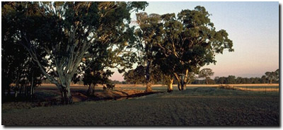
General Site Description: Near minor tributary on Avoca river flats.
Geology: Quaternary alluvium (Shepparton Formation).
 Site LP113 Soil Landscape |
Soil Profile Morphology:
| Surface Soil | 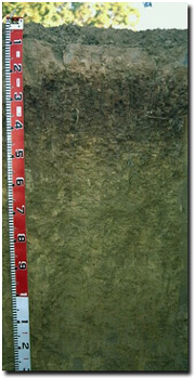 Site LP113 Soil Profile | ||
| A1 | 0-10 cm | Dark yellowish brown (10YR4/4); sandy loam; very firm consistence (dry); pH 5.5; sharp change to: | |
| A2e | 10-18 cm | Dark brown (7.5YR4/4); conspicuously bleached (5YR7/3d); fine sandy clay loam; strong consistence (moderately moist); 5% pores; pH 7.1; change to: | |
| Subsoil | |||
| B21 | 18-45 | Strong brown (7.5YR4/6); light medium clay; moderate medium sized blocky structure, parting to strong fine blocky structure; very strong consistence (moderately moist); pH 7.5; most roots stop at 45 cm; abrupt change to: | |
| B22 | 45-150 cm | Yellowish brown (10YR5/6 and 5/4); light medium clay; firm consistence (moist); pockets (5-8 cm) of fine-earth carbonates; pH 8.8; clear change to: | |
| B23 | 150-200 cm | Yellowish brown (10YR5/8); light medium clay; strong consistence (moist); few (< 2%) manganese stains; pH 8.4. | |
Key Profile Features:
- Strong texture contrast between surface (A) horizons and upper subsoil (B21) horizon.
- Conspicuously bleached subsurface (A2) horizon.
pH | Salinity Rating | |||
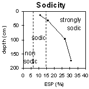
Surface (A1 horizon) | Strongly acid | Very low | Marginally Sodic | None |
Subsoil (B21 horizon) | Slightly alkaline | Moderate | Strongly sodic | Strong |
Deeper subsoil (at 150-200 cm) | Strongly alkaline | Moderate | Strongly sodic | Strong (at 50-70 cm) |
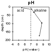 | 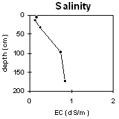 |  |  |
Horizon | Horizon Depth | pH (water) | pH CaCl2 | EC dS/m | NaCl % | Exchangeable Cations | Ex Al mg/kg | Ex Ac meq/100g | Field pF2.5 | Wilting Point pF4.2 | Coarse Sand (0.2-2.0mm) | Fine Sand (0.02-0.2mm) | Silt (0.002-0.02mm) | Clay (<0.002mm) | |||
Ca | Mg | K | Na | ||||||||||||||
meq/100g | |||||||||||||||||
A1 | 0-10 | 5.5 | 4.8 | 0.16 | 3.2 | 1.3 | 0.5 | 0.46 | 10 | 33.3 | 8.3 | 1 | 46 | 35 | 16 | ||
A2e | 10-18 | 7.1 | 6 | 0.13 | 3.4 | 3.8 | 0.35 | 0.89 | 25.1 | 10.3 | 0 | 40 | 33 | 29 | |||
B21 | 18-45 | 7.5 | 6.5 | 0.25 | 0.15 | 4.2 | 7.8 | 0.56 | 2.4 | 30.9 | 16.9 | 0 | 20 | 34 | 47 | ||
B22 | 45-150 | 8.8 | 8.1 | 0.74 | 0.19 | 3.2 | 6.2 | 0.37 | 3.5 | ||||||||
B23 | 150-200 | 8.4 | 7.7 | 0.85 | <0.05 | 2.6 | 8.9 | 0.74 | 5.5 | ||||||||
Whole Profile
- Management strategies for all soils should aim to increase organic matter levels in the surface soil; minimise the degradation of soil aggregates and porosity; promote the development of stable biopores; improve the calcium status of the cation complex (when sodium is a significant part – i.e. sodic) and break up any hardpans. Less frequent tillage, using less aggressive implements, and working the soil at optimum moisture contents can all assist in maintaining soil aggregation and porosity as well as reducing the breakdown of organic matter.
- Plant available water capacity (PAWC) is estimated to be very low (estimated at 30 mm) for the profile (for a effective rooting depth of 18 cm). This is based on the available laboratory data and assumes an effective rooting depth of 20 cm.. Effective rooting depth will be restricted by the strongly sodic subsoil and the level of soluble salts.
- Values of exchangeable magnesium are greater than 45% from 10 cm down (up to 52% with depth). Such levels in some soils may induce potassium deficiency (Baker and Eldershaw, 1993).
- The surface horizons have a low inherent fertility (based on the sum of the basic exchangeable cations).
- The bleached subsurface (A2) horizon indicates that periodic waterlogging occurs on top of the more slowly permeable subsoil. This horizon is likely to become 'spewy' as a result.
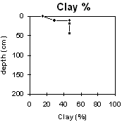
- The level of the organic carbon indicates that the organic matter of the surface soil is moderate. Organic matter is important for reducing slaking and enhancing soil aggregation, fertility and water holding capacity in soils with a high content of fine sand (46%) and silt (34%). Organic matter levels will build up under pasture but will decline if cultivation takes place. Practices such as residue retention, minimum tillage and including pasture rotations should be utilised if cropping occurs.
- The surface horizon has a moderately low pH. This can lead to toxic levels of Aluminium being available to the plants. In this case, the exchangeable Al level is quite low and is only likely to affect some of the most highly sensitive species. Lime can be used to increase soil pH but it should be noted that a pH/aluminium test is best performed from samples taken across the paddock and bulked together. Other factors also need to be considered before lime is recommended (e.g. pasture species grown, method of application, local trial responses, soil surface structure and likely cost/benefit).
- The moderate-high level of soluble salts from 18 cm depth may affect the growth of salt sensitive species.
- The subsoil is strongly sodic and strongly dispersive with a low calcium to magnesium ratio (<1). This will result in restricted root and water movement in the subsoil. Water is likely to build up on the top of the subsoil after heavy rains causing waterlogging of the more porous surface horizons.
- Has been cleared for about seventy years.
- Grown lucerne for the last three years.
- Gypsum applied about every ten years at 2 tonnes/acre.
- Rotation of four crops then clover or lucerne for three years.
References:
Baker, D.E. and Eldershaw, V.J. (1993). Interpreting Soil Analysis for Agricultural Land Use in Queensland. Project Report Series. Queensland, Department of Primary Industries.
© State of Victoria (Agriculture Victoria) 1996 - 2025.

This work, Victorian Resources Online, is licensed under a Creative Commons Attribution 4.0 licence. You are free to re-use the work under that licence, on the condition that you credit the State of Victoria (Agriculture Victoria) as author, indicate if changes were made and comply with the other licence terms.
The licence does not apply to ‘branding’ or some ‘images or photographs’ that may be owned by third parties. We ask you to seek prior approval to use images using the VRO feedback form. Access to higher quality images can also be provided on request.
This page was last updated on 23/03/2020.