
Heywood Land System
|
|
|
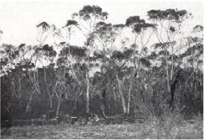 Plate 10 - The Heywood land-system (Flat, low-lying of poor regional drainage. Most of the soils are reasonably fertile and support a swamp sclerophyll forest of this kind. | There are two stretches of country in the survey area both of which are flat, low-lying, poorly drained and covered mainly with clayey deposits. One is that part of the Follett Plains - the country west of the Kanawinka fault - where dunes and sheets of sand are absent or very thin. It has been mapped as the Strathdownie land-system. The other is the eastern zone of the Normanby Platform. This platform was lifted up at its western edge to form a scarp along the line of the Kentbruck fault and has been covered subsequently in the west by Cobbobboonee basalt and slopes gently down to the east to form the basement of the coastal plains around Heywood and Bessiebelle. This latter stretch of country has been mapped as the Heywood land-system and may be defined as the coastal plains, the basement of which is the Miocene limestone of the Normanby Platform. The Heywood and Strathdownie land-systems which together form the Heywood land-zone, are similar in physiography and in some of the soil features, but they differ in regional drainage. In the Strathdownie land-system, because of obstruction by lines of Pleistocene dunes, this drainage is through parallel lines of swamps transverse to the direction of fall of the land. In the Heywood land-system, there is no such obstruction except along its coastal edge, and the drainage is by rivers which flow more or less directly to the coast. Consequently, the deposits in the Strathdownie land-system are lacustrine whilst in the Heywood land-system riverine deposits are more prominent and the topography is not so flat. Other differences are the greater influence of the Miocene limestone basement on surface features for the Heywood land-system and particularly the wetter climate of the Heywood land-system - above 30 inches as compared with less than 30 inches in the Strathdownie land-system. Ardno land-unit, a part of the Strathdownie land-system with 29 inches rainfall, is like the Homerton and Bessiebelle land-units of the Heywood land-system with 31 inches average annual rainfall. |
The Heywood land-system is more diverse in character than other land-systems in the survey area and it would be difficult to give a unified treatment in any comprehensive account. For this reason, further sonsideration of the land-system is on the basis of five sub-systems into which the land-units conveniently fall.
Heywood Sub-system
This comprises Heywood, Bessiebelle, Bessiebellel, Homerton and Shaw land-units and covers nearly half the total area of the land-system, 70,000 acres out of 160,000.
Parent material is riverine or lacustrine alluvium of some depth overlying the Miocene limestone, and the upper layers of the alluvium are clayey and usually with ortstein (nodular ironstone) or mottled clay at shallow depth. Probably the ortstein and the mottled clay are relic formations of a wetter and colder period and were associated with swamps. Most likely, the ortstein is of similar origin to that frequently and characteristically found as a surface alteration of basalt in the Cobbobboonee land-system and of similar origin to that occasionally found in the Strathdownie land-system and the Hotspur land-unit of the Greenwald land-system. There are small areas where acid white sands form a veneer, usually thin.
Vegetation in this sub-system is somewhat varied as to formation; heath woodlands, heath sclerophyll forests and heaths predominate, with some areas of savannah and tall woodlands and occasionally of dry sclerophyll forests. The chief species however are limited to swamp gum (Eucalyptus ovata) and a few heath species, particularly Leptospermum and Casuarina, in nearly all these formations; manna gum (E. viminalis) and peppermint (E. vitrea) are frequent on the slightly drier sites. One of the chief features of the original vegetation over most of this sub-system was the density and unpalatable nature of the ground storey, which allows no substantial use of the land until after almost complete clearing, and makes it difficult to clear the land and keep it cleared.
Chief soils in the sub-system are medium-textured leptopodsols, meadow soils and some solodic soils where there is a sand veneer; prairie soils constitute a substantial minority of the soils. All of them are deep and are medium or heavy in texture in the subsoil and usually at the surface also; they usually show signs of being wet for a considerable part of the year in the lower horizons. Consequently, they have a high soil-water holding capacity, and, in the high average rainfall characteristic of the land-system, are well suited to deep-rooted perennials which require to be supplied with moisture throughout the season. Also, the nutrient status of these soils is usually moderately good, rarely low and sometimes high. Because this is combined with the generally satisfactory moisture-supplying power for suitable species, there is a considerable agricultural potential over most of the sub-system.
Some of this potential was developed some time ago when dairying was established around Heywood and Bessiebelle in parts of the land-units of those names and in the Homerton land-unit. Drainage was necessary around Bessiebelle, as Bessiebelle, sub-unit was originally very swampy. Elsewhere in this sub-system, land-use until recently has been restricted to fine-wool growing or cross-bred wool growing particularly in the Homerton land-unit, or else the land has remained undeveloped although capable of intensive use based on perennial pastures. A recent upsurge of development, around Heywood particularly, is a recognition of this potential, and forests of swamp gum or dense wet heaths have been transformed to dairy farms and to properties growing cross-bred wool and fat lambs.
One reason for the late development of this country of high potential is probably that, because of the wetness and the soils, it is difficult to prevent cleared areas from reverting to dense wet heaths. To do this required intensive skilled management involving much labour and expenditure on improved species and fertilisers. Co~sequently, only enterprises with a high return per acre are economical, and despite a high potential productivity, development is restricted according to the ability of the landholder to obtain high yields with low costs of production. Recent intensive development of country in these land-units is a result therefore of a combination of present high returns and capital attracted by lower taxation in primary industry. The high returns arise from the ease of clearing this kind of scrub with modern machinery, improved local facilities for marketing dairy produce, the demand for beef and fat lambs, and the higher carrying capacities possible with improved species and fertilisers.
Dunmore Sub-system
A second group of land-units is characterised by numerous small swamps which may occupy up to a third of the immediate area. It includes the Dunmore, Saint Helen's and Tyrendarra land-units and covers 46,000 acres. In Dunmore land-unit, the alluvium is probably early Pleistocene and has been strongly weathered during some previous climate to give a residual ortstein near the surface and rather more undulating topography which is further modified by small surface deposits of acid white sands. Swamps in Dunmore land-unit are about 200 yards across, oval in plan and point in a north-northwesterly direction; they may be a result of tectonic fracturing of the limestone bed, and percolation and solution at regularly-spaced points of weakness. Saint Helen's land-unit is similar, but Tyrendarra land-unit has Miocene limestone near the surface, is undulating, possibly because of solution of the limestone whilst the resulting swamps are subcircular and randomly distributed.
In the Dunmore sub-system, the original vegetation was a complex, and much still remains. The chief type in this complex was a dry sclerophyll forest of messmate (E. obliqua), with which were mixed peppermint and stringybark (E. baxteri) in Dunmore and St. Helen's land-units, but manna gum and swamp gum in Tyrendarra land-unit. Scrubby dry sclerophyll forests of stringybark and scrubs or wet heaths are associated with the sands and swamps respectively, in the complex. Chief soils are medium-textured leptopodsols, with nomopodsols on the sands, meadow soils and some solodic soils. The potential of the majority of the soils is similar to that of the soils of the Heywood sub-system, but the potential of the sub-system itself is not similar. This is not only because of the influence of the minority of infertile nomopodsols but also because, even where the soils are similar, the problems of development are greater because of the regular occurrence of small swamps with difficult drainage problems.
The native timber resources of the land-system as a whole are virtually restricted to the messmate and stringybark of this Dunmore sub-system. Messmate requires moderately deep, moderately fertile and well-drained soils for good growth, and in the land-system these conditions are fulfilled only by the combination of the gravelly medium-textured leptopodsols on the ortstein of the older alluvium, with the more undulating topography of the Dunmore and Saint Helen's land-units namely, component seven of the land-system diagram. Elsewhere the soils are too wet owing to their character or location, or else too infertile for good messmate, whilst the native timber of those sites, chiefly swamp gum or scrubby stringybark, is no good for milling. In the Heywood land-system, component seven resembles the dominant component one of the Cobbobboonee land-system, which is the chief producer of native hardwood in the survey area. Pines (Pinus radiata) can probably grow in these parts of the Dunmore sub-system where messmate grows naturally.
Fitzroy Sub-system
A third group of land-units comprises areas where acid white sands cover the surface of other land-units. Fitzroy and Homerton, compose this sub-system and cover about 18,000 acres. In character they resemble wetter parts of the Follett and Kanawinka land-systems, and have similar soils and vegetation. The soils are chiefly nomopodsols and in the Fitzroy land-unit there are also acid marsh soils. The vegetation is of scrubby forests or heath woodlands of stringybark and also wet heaths. Like the wetter parts of the Kanawinka and Follett land-systems they can grow perennial pastures but with high costs of drainage, clearing and fertilizing.
Margaret Rose Sub-system
Two small land-units, Heywood, and Margaret Rose - so-called from the celebrated caves of that name near Nelson - compose this sub-system. Miocene limestone outcrops at the surface to give terra rossas which support manna gum and some peppermint in tall woodland formation. In Heywood, sub-unit sandy leptopodsols on orange sands are associated with terra rossas and carry similar vegetation, with more bracken, but the area mapped as Margaret Rose land-unit has but shallow terra rossas and bare rock is common. Soils are well drained where deep enough, but only moderately fertile. They are capable of supporting annual species where shallow, and perennial species where deeper.
Codrington Sub-system
The Codrington land-unit, which does not fall readily into the above-mentioned sub-systems, is distinct enough to form a sub-system itself. It is predominantly of shallow alluvium overlying Miocene limestone with restricted areas of Pleistocene dune limestone and veneers of Holocene sand. The chief soils are shallow prairie soils and shallow rendzinas and in wetter spots there are meadow soils; terra rossas and solodic soils of the Follett family are associated with the limestone and sand respectively. The original vegetation probably had a dense cover of low heaths, but may have contained stunted swamp gums ; it has been largely cleared and modified. Codrington land-unit, in geomorphology and soils, closely resembles the Furner Soil Association and much of the Millicent Soil Association of Blackburn (1959) which are found around Hatherleigh in the lower south-east of South Australia. There, the Millicent clay, the most widespread soil, can grow excellent strawberry clover for seed production as at Konelgin. Whether or not the Codrington landunit could be used for a similar purpose is not certain, because in the Furner and Millicent Associations, periodic flooding can play an important part in providing suitable soil moisture conditions and the incidence of such flooding in the Codrington land-unit is not known.
Erosion
In the Heywood land-system, both the hazard and manifestations of erosion are slight. A low relief ver to be retained sufficient to further reduce the risk of sheet and gully erosion and prevent wind-erosion of the sands. Drains are frequent in developed country, but there is little evidence of their erosion.
Summary
The characteristics of the land-system are somewhat diverse, but a broadly uniform physiography and generally good rainfall make for a fairly uniform potential. The landscape consists of coastal plains, with a basement of the Miocene limestone of the Normanby Platform, and superficial deposits. Where these latter are Pleistocene lacustrine or riverine alluvium as they usually are, there is a resemblance to the Strathdownie land-system. Five sub-systems are recognised on the basis of the occurrence and nature of the superficial deposits and of swamps.
Soils generally are good, and in the prevailing climate make for a high agricultural or grazing potential with little hazard of erosion. Vigorous and dense ground-storey vegetation in one sub-system and regional drainage patterns in another sub-system cause problems in the development of this potential however, whilst in a third, the poorer soils make for higher costs in the attainment of the potential. This demonstrates the principle that even where the potential is dominated by certain over-riding factors, any one of the other features of the environment may modify, in a different way and to a different extent, the problems encountered in attaining the potential, and therefore may modify the economic potential itself. This further illustrates the need to consider each feature of the environment in relation to all the other features, when the area is being mapped.
© State of Victoria (Agriculture Victoria) 1996 - 2025.

This work, Victorian Resources Online, is licensed under a Creative Commons Attribution 4.0 licence. You are free to re-use the work under that licence, on the condition that you credit the State of Victoria (Agriculture Victoria) as author, indicate if changes were made and comply with the other licence terms.
The licence does not apply to ‘branding’ or some ‘images or photographs’ that may be owned by third parties. We ask you to seek prior approval to use images using the VRO feedback form. Access to higher quality images can also be provided on request.
This page was last updated on 23/03/2020.