
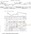
Greenwald Land System
 |
|
In south-western Victoria, there is rolling sedimentary country under moderately high rainfall, with soils of moderate fertility and which carries forests or tall woodlands of peppermint and manna gum with some swamp gum and messmate. This situation is virtually restricted to where the Normanby Platform (Fig. 10) or the southern edge of the Dundas Tablelands are dissected to expose early and mid-Tertiary sediments. Consequently, examples of such country may be found scattered through the Cobbobboonee and Heywood land-systems and southern parts of the Branxholme and Glenelg land-systems. Where this kind of land forms the greater part of the landscape, however, it has been mapped as the Greenwald land-system. The name is taken from a small hamlet between Heywood and Dartmoor.
Cobbobboonee basalt covers the higher, western part of the Normanby Platform and part of the southern fringe of the Dundas Tablelands, and the Greenwald land-system is defined as areas beneath the level of the Cobbobboonee basalt where underlying sediments, chiefly early and mid-Tertiary, are exposed.
Cobbobboonee basalt is hard and not easily weathered whereas the underlying sediments are soft and quickly dissected. Consequently, as for the Glenelg land-system, an escarpment is formed along the edge of this land-system where it joins the basalt or tablelands, and the steep slopes of the juvenile stages of dissection persist until the hard capping has been removed. The land-system has been subdivided according to steepness of dissection into two sub-systems. The first is Crawford, characterised by juvenile dissection with prominent escarpments, generally narrow valleys and by many of the slopes being steep and long; and the second is Springbourne with more mature dissection, gentler slopes and wider valleys. The land-system is discussed further on this basis.
Crawford Sub-System
The long and steep slopes typical of the Crawford sub-system are found in three localities within the Greenwald land-system.
(i) The western edge of the Normanby Platform overlooks the Follett Plains by an escarpment about 400 feet high which has resulted from the Kentbruck and Drik Drik faults. The Crawford River flows along the junction of the northern flank of the Normanby Platform and the southern edge of the Dundas Tablelands, onto the Follett Plains, and has cut a valley nearly 300 feet deep in the northern part of the escarpment. There, however, the valley is narrow, despite its being wide upstream. This is because, as shown by Kenley and described by Boutakoff (1963), the original course of the Crawford was not onto the Follett Plains, but was south from what is now Lower Crawford Homestead through a series of swamps to link up with the valley of what is now the Fitzroy River. This stream was subsequently captured just south of Lower Crawford by a tributary from the Glenelg at Dartmoor which was dissecting rapidly upstream. Consequently, the section of the present Crawford River below the point of capture and above the fault escarpment was and still is much more juvenile and the dissection therefore much steeper. The Greenwald land-unit includes this juvenile section of the Crawford River together with a small section above Lower Crawford and some of the fault escarpment itself. The Crawford catchment upstream however, with more senile topography, is in the Springbourne sub-system.
(ii) A second locality is south of Whittlebury Swamp in the parish of Condah and is mapped as the Whittlebury land-unit. Here, the escarpment of the presumed fault, marking the southern edge of the Dundas Tableland at its junction with the Normanby Platform, shelves rather gently to the south. Steep and deep dissection, comparable to the steepest parts of the Greenwald land-unit, has resulted from the Whittlebury Creek cutting back from a well-entrenched valley on the east (the continuation of the valley of the Condah Swamp which now carries flows of the Eccles basalt). However, some of the dissection on the cast of the land-unit, including the old Aboriginal Reserve, is more mature and the gentle southerly slopes of the escarpment are less severely dissected. Deep weathering of the sediments of these latter slopes is a prominent feature; it may be a relic of late Tertiary weathering preserved by the locally gentle topography.
(iii) The slopes around Mount Clay form the third locality, mapped as the Ettrick land-unit. Faulting, not dissection, is the cause of the escarpment, and dissection has been purely local on the escarpmented slopes. In contrast with other land-units in the sub-system, the slopes of the Ettrick land-unit have been influenced by tuffs and local lava flows from Mount Clay and also by some acid white sands; these deposits cover the sediments in parts.
These three land-units together form the Crawford sub-system of 26,300 acres extent. Their common features are geomorphological. The physiography is broadly similar-escarpments are prominent, valleys narrow and most slopes steep and long, resembling the southern land-unit (Digby) of the Glenelg land-system and parts of Branxholme land-system. Tertiary sediments which are exposed have a consistent range of lithology including sandy sediments and limestone although there are differences in the minor parent materials. Over all the sub-system the average annual rainfall exceeds thirty inches, reaching thirty-five inches in part of Greenwald land-unit.
The narrow range of rainfall and a consistent range of lithology result in a limited range of soils. The chief soils are medium-textured leptopodsols and in a few localities, soils intermediate between these and solodic soils. Minor soils are usually of Order VII and include brown earths with chocolate soils and, on the basaltic tuff, transitional krasnozems; meadow soils are frequent on the valley floors and sometimes contain ironstone. The nutrient status of most of these soils is moderate and certainly not low; this is important because the combination of climate and soil physical features allows prolonged seasonal growth and therefore intensive farming with its heavy demand on soil nutrients.
The combination of wet climate and moderately fertile and deep soils has also produced the characteristic vegetation of this sub-system a dry sclerophyll forest dominated by peppermint (Eucalyptus vitrea) with manna gum (E. viminalis) and messmate (E. obliqua) as the chief associated tree species and with swamp gum (E. ovata) in the wetter sites such as drainage lines or valley floors. Messmate is in drier sites, particularly on the well-drained soils with clayey subsoils and manna gum is on soils of good fertility if they are well-drained. Blackwoods (Acacia melanoxylon) may be associated with swamp gum in wet positions especially on fertile soils of Order VII (the Earths). In the most favoured parts, these latter species form a luxuriant wet sclerophyll forest, and tree-ferns (Dicksonia antarctica) are found, although very rarely, in sheltered and fertile sites in the Glenaulin Lower Crawford area. Woolly tea-tree (Leptospermum lanigerum) is also present in the wettest sites and after the landscape has been cleared it regenerates, to form thickets in drainage lines and soaks, the whole appearance of the landscape being reminiscent of parts of the Otways or Strezlecki Ranges. Messmate is the chief commercial timrer of these species and is milled, although there is not much of it in the sub-system, a good deal of which has been cleared for grazing.
The most important feature for land-use is the climate, in conjunction with the soils, particularly for the Greenwald and Ettrick land-units. There, not only is the rainfall high but the chances of receiving summer showers are higher than for most other places in the survey area. The effect of this is that not only can perennial pastures contribute feed throughout the summer months but also that summer fodder crops can be grown if they can tap sufficient reserves of soil moisture. For this, deep-rooted species and a moderately deep soil containing, some clay in the subsoil are needed. Such soil features are common in the sub-system.
Much of this sub-system therefore has a high potential. Originally, cleared areas were used for Merino wool growing, cross-bred wool growing and some dairying, on native pastures. Improved perennial pastures can be established, particularly on the gentler slopes, to support cross-bred wool growing with fat lambs, beef cattle raising and dairying. On cropping areas on gentle slopes or valley floors, summer fodder crops and cash crops can be grown.
It is not difficult to maintain a vegetative cover with the high rainfall, and the erosion hazard after clearing is correspondingly low. Long and steep slopes however create a hazard despite the favourable climate, and in the steepest parts of Greenwald and Whittlebury land-units, there is a moderate gully erosion hazard, manifested on cleared areas, and occasional earth flows. In Ettrick land-unit, there is some roadside erosion.
Springbourne Sub-system
Land where dissection beneath the level of the Cobbobboonee basalt has produced gentler slopes than in the Crawford sub-system is identified as the Springbourne sub-system.
An undulating to gently-rolling topography is typical, apart from the escarpment adjoining the tablelands, and in the Hotspur land-unit, there is also a wide main valley. There is a number of such localities throughout the Cobbobboonee landsystem where it is dissected more deeply than usual, particularly the Sunday Creek Valley near Annya and in the north of the parish of Cobbobboonee. These could logically have been mapped as the Springbourne sub-system at a larger scale of mapping. Extensive continuous areas however are found in parts of the catchments of the Crawford River above its point of capture and these, totalling 47,000 acres, make up the sub-system.
Two distinct areas are involved. The smaller is the catchment of the Springbourne Creek, south-east of Lower Crawford, mapped as the Springbourne land-unit. Most of this land-unit has a gently-rolling topography with occasional small remnants of basalt. It carries medium-textured leptopodsols, some soils intermediate between these and solodic soils and brown earths on the basalt remnants. A dry sclerophyll forest of peppermint and swamp gum is typical, with manna gum on the richer and drier sites and messmate on the drier sites. Tall and dense scrubs of woolly tea-tree follow drainage lines and other wet spots. In the north-east of the land-unit, towards the Annya escarpment, are sheets of acid white sands with nomopodsols supporting heath woodlands of stringybark. Much of the land-unit is uncleared, but there is no doubt that in the 32-33 inch rainfall those parts not covered with acid white sands, can be developed to cross-bred wool growing with fat lambs, beef cattle raising or dairying on perennial pastures.
The larger part of the subsystem is the main valley of the Crawford River around and beyond Hotspur as far as the plateau of the Hamilton land-system; it includes the area between the right bank of the Upper Crawford River and the Dundas Tablelands in the parish of Winyayung. All of this has been mapped as the Hotspur land-unit but it is rather more diverse in its features than the other land-units and overall is somewhat different. The escarpment is usually distinct but not prominent and sometimes is absent as to both the south-east and north-west of Hotspur. Any steep slopes are confined to the peripheral escarpment itself and elsewhere most slopes are gentle. In the north-east, the land-unit merges into the Morven land-unit of the Branxholme land-system and the river is an arbitrary boundary. In fact, the Hotspur land-unit is itself transitional in character between the rest of the land-system and the Branxholme land-system. Scattered areas of acid white sands are near the Winyayung land-unit. A distinctive feature of the land-unit is the wide main valley in which there are remnants of old alluvial terraces. On parts of these are boulders of ortstein (nodular ironstone), probably representing a former swampy valley floor or lake-bed. It may be similar in origin and age to the ortstein sometimes found in the Heywood land-system and perhaps also to that associated with the Cobbobboonee basalt.
Some of the Hotspur land-unit, which has an average annual rainfall as low as 29 inches, is drier than other parts of the land-system, and this may be responsible for the differences in soils and vegetation. Solodic soils, and soils intermediate between these and the leptopodsols of the other land-units, dominate most sites away from the low positions where there are meadow, alluvial and prairie soils. Originally, the vegetation was probably a tall woodland of manna gum, swamp gum, some peppermint and snow gum (E. pauciflora) on the gentle slopes. It thins to a savannah woodland on the wetter parts of the valley floor. On steeper parts, the association becomes more dense, forming a dry sclerophyll forest and includes messmate but not swamp gum. The undulating old terraces with ortstein boulders, intermediate solodic-podsolic soils and remnants of woodlands of snow gum and swamp gum strongly resemble the Homerton land-unit of the Heywood land-system.
Much of this land-unit, particularly the valley floor, was cleared early after settlement and was used for Merino wool growing. Pastures of perennial and late annual species can be established for cross-bred wool growing with fat lambs and for beef cattle raising.
In the Springbourne sub-system, although the gentle slopes are less conducive to erosion hazard than are the steep slopes of the Crawford sub-system, thu lower rainfall, by contrast, accentuates the hazard. Consequently, in both sub-systems, the range of erosion hazard is similar. Thus, Hotspur land-unit, with gentle slopes but the lowest rainfall of the Springbourne sub-system, has a moderate sheet and gully erosion hazard, similar to the hazard in Greenwald land-unit, which has the steepest slopes in the well-watered Crawford sub-system. Most other parts of both sub-systems, however, have a low hazard of sheet and gully erosion.
Summary
Rolling country of Tertiary sediments exposed by dissection or faulting, in moderately high rainfall in south-western Victoria, once supported forests or tall woodlands in which the chief species was peppermint. Manna gum, swamp gum and sometimes messmate were associated with the peppermint, with woolly tea-tree in the wet sites. Such country occurs in small areas in low parts of the Cobbobboonee land-system but where it forms a continuous stretch it has been mapped as the Greenwald land-system. Soils are mainly medium-textured leptopodsols and soils intermediate between these and solodic soils. Brown earths and meadow soils are less common.
Two sub-systems, the Crawford and Springbourne, are steeply rolling and gently rolling respectively and are linked with the history of faulting and dissection. Most parts except the driest or steepest have a high agricultural potential based on perennial pastures, and the best-watered localities can grow summer fodder crops. There is scope for development. Sheet and gully erosion hazard varies from low to moderate according to steepness of slope and dryness of climate and is manifested in a few parts.
In brief, the land-system is well-watered and well-timbered, rolling, sedimentary country with moderately good soils, fairly high agricultural potential and low to moderate erosion hazard.
© State of Victoria (Agriculture Victoria) 1996 - 2025.

This work, Victorian Resources Online, is licensed under a Creative Commons Attribution 4.0 licence. You are free to re-use the work under that licence, on the condition that you credit the State of Victoria (Agriculture Victoria) as author, indicate if changes were made and comply with the other licence terms.
The licence does not apply to ‘branding’ or some ‘images or photographs’ that may be owned by third parties. We ask you to seek prior approval to use images using the VRO feedback form. Access to higher quality images can also be provided on request.
This page was last updated on 23/03/2020.