
Discovery Bay Land System
 |
|
Victoria has a coastline which in many places is fringed with high dunes of recently-deposited sands, some of them actively shifting, but nowhere, however, are these dunes so extensive nor shifting so widely as along the length of Discovery Bay.
There, the sand composing these dunes is highly calcareous, made up very largely of finely-broken sea-shells, with a small proportion of quartz grains. All the landscape which is covered by dunes of this kind of sand has been termed the Discovery Bay land-system. It occupies about 20,000 acres, 0.7 per cent of the area, and of this over three-quarters, 15,400 acres, is Crown land, the remainder being alienated.
About 2,000 acres of the land-system is a long narrow strip just behind the beach itself, from Yambuk to the cliffs at Portland, but the greater part, 18,000 acres, lies between Cape Grant and Nelson near the South Australian border.
The system contains three land-units which differ fundamentally in the period during which they have been stable. From this arise differences important for land-use, the chief of which are the native vegetation and the amount of organic matter accumulated in the soils. To these three land-units, the names Discovery Bay, Baudin and, Tarragal have been given.
The Discovery Bay land-unit (plate 4) comprises those sand dunes which are bare except for scattered areas of marram grass, and of which the surface in most parts is drifting. Between Yambuk and Portland, the thin strip of the land-system along the coast belongs to this land-unit. Again, to the west of Portland are two distinct areas of this land-unit. One, of 1,500 acres, extends in a crescent inland from Bridgewater Bay, and the other is a strip up to three miles wide, adjacent to Discovery Bay and covering 9,500 acres. High, steep dunes are a feature of this, and also of the other two land-units in the land-system, and some are two hundred feet high. In parts of this land-unit, the sand has been blown up the escarpment of the Bridgewater fault and the dunes on the plateau surface may reach to four hundred feet above sea-level. As they are shifting now, there is a complex of encroaching dunes with steep slip-faces, and of degrading dunes with sand removed down to an erosion pavement. The erosion pavements may be former surface layers with enough organic matter to make them coherent, sand layers cemented by some other materials, or the core of dune limestone and coherent ancient red soils which underlie most of the land-system. Even aboriginal middens and artifacts, because of their coherence and size, may form small local erosion pavements. A few parts are covered with scrubby vegetation, but mostly the area is bare.
Except for the erosion pavements, the "soils" throughout this land-unit appear similar. They are regosols and only the one type, Discovery Bay sand, has been encountered. In essence, they are just undifferentiated sand, without even any darkening by organic matter, although zones of marram grass roots may be seen at intervals and probably represent the surface before the next covering of sand. One feature however, is outstanding if not unique-the pH value is extremely high, above 9.0 throughout the profile, and sometimes above 9.5. Quantities of the various nutrients are low to moderate, mainly low, but not as low as in nearby leached sands such as the sandy leptopodsols and especially the nomopodsols.
The Baudin land-unit comprises dunes that are not shifting and are covered with a dry scrub of coast wattle (Acacia sophorae), muntries (Kunzea spp.), heaths (Leucopogon spp), occasional she-oak (Casuarina stricta), pigface (Carpobrolus spp.) and sand-spinifex (Spinifex hirsutus). This land-unit fringes the Discovery Bay land-unit inland from Bridgewater Bay and Discovery Bay. Its general topography is similar to that of the Discovery Bay land-unit, although erosion pavements are not obvious. Soils closely resemble the Discovery Bay sand, but have a slight darkening in the upper part as a result of organic matter accumulation, and have been named Discovery Bay loamy sand. The high pH is still a feature of the soil. Sometimes the surface may be covered by up to a few inches of lighter-coloured sand not darkened by organic matter and doubtless blown onto it recently.
In the parish of Tarragal, the land-unit of that name consists of steep but smoothly-rounded sand dunes, rising gradually towards the centre of the unit, and culminating in some high and prominent peaks. Although now largely cleared, it appears to have been covered originally by a tall dry scrub of coastal tea-tree (Melaleuca pubescens), and she-oak (C. stricta) and has probably been stabilised for about 1,000 years on the basis of radio-carbon dating of similar soils at Warrnambool. This has resulted in the accumulation of much humus in the topsoil, and has produced a very dark brown layer, of thickness varying from 6 inches to 36 inches according to topographic position and aspect. The soil itself, named Tarragal sandy loam, is regarded as a brown earth of high base status, and although the lower layers retain the high pH values of the unaltered calcareous sand, the upper horizons show a marked decline in pH values to around 8.0 or less. When cleared, the Tarragal land-unit (plate 6) supports a reasonable although sometimes sparse sward of lime-tolerant native grasses, principally hare's tail or pussytail (Lagurus ovatus), except on eroded or disturbed areas, where marram grass is found. As with all land-units in this land-system, bracken is significantly absent, no doubt because of the high pH values of the soil. This land-unit can be readily improved to annual or perennial clovers and introduced grasses as the average annual rainfall is about 31 inches. To do so, however, not only superphosphate, but also copper and zinc are needed, together with cobalt for stock. Cash crops and fodder crops which can tolerate alkaline conditions should do well on this land-unit.
| The erosion hazard of the land-system is a cause for concern. Even on the Tarragal land-unit, although it can be satisfactorily improved, there are parts where the organic topsoil is thin. If, oil these parts, the underlying sand be exposed by rabbits' activity or the cutting down of tracks, then the sand blows readily, creating an eroded patch known as a "blow". This extends until it reaches an area where the depth of coherent surface soil is great enough to resist further removal. Blows, usually small, but also frequent, are therefore a feature of parts of this land-unit, particularly on the steeper slopes or ridges where the organic topsoil is thinner. The stability of the Baudin land-unit is extremely precarious however, and the Discovery Bay land-unit is in a complete state of flux. Although in parts the shifting dunes of the Discovery Bay land-unit are being stabilised by marram grass and shrub acacias, elsewhere on the Discovery Bay land-unit and in a few places on the Baudin land-unit, blows are developing and sand encroaches onto other parts of both units, and also onto adjacent land of higher agricultural potential (plate 7). | 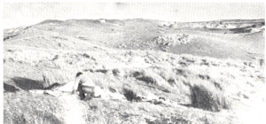 Plate 6 - The Tarragal land-unit (Consists of dunes of calcareous sand which have been stabilised by dense scrubs of coastal tea-tree (Melaleuca pubescens) and she-oak (Casuarina stricta), now largely cleared. The soils are subject to localised patches of wind erosion, as shown here.) |
| The rate of encroachment on to the Baudin or other units is uncertain. Steep slip-faces of active blows are covering living vegetation, but the rates of advance have not been measured. At Wilson's Promontory in south-eastern Victoria, certain blows have encroached at the average rate of 1-8 chains per year over the last sixteen years. However, a perusal of the original parish surveys in the Portland area, dating back over one hundred years, shows a variety of rates of advance, from 0.01 chain per year to 0.8 chain per year. Moreover, the bare dunes of the Discovery Bay land-unit are directly menacing the better-class country of the Nelson landsystem along only part of their inland perimeter, but are mostly contained by the Baudin land-unit, so that it is ditficult to estimate just how serious is the hazard of the encroaching sands. | 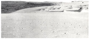 Plate 7 - The sands of the Discovery Bay land unit (Actively shifting and slowly covering some land of higher potential.) |
What were the historical relationships of the land-units of this land-system? Because of the nature of the soils, it is evident that the Tarragal land-unit became stable earlier than did the Baudin land-unit, and this latter itself seems to have been stable for some time, to judge from the gradual merging of its edges with the clearly stable Long Swamp land-system. However, Grant's description of wooded hills gently rising from the shores of Discovery Bay and Bridgewater suggest that at the beginning of settlement, the Baudin land-unit stretched virtually to the coast. Therefore, the Discovery Bay land-unit has probably developed largely at the expense of the Baudin land-unit since settlement in the period 1840-1845. If this is so, then the evidence of the earliest parish plans of the period 1854-1860, which show the boundary of the shifting sands near its present position, indicates that the shifting sands must have developed shortly after settlement.
How did the widespread destruction of the Baudin land-unit start? The resistance of the bare sand to detachment and movement by the prevailing high winds is so low that probably any destruction of the vegetation by fires, grazing or tracks would have precipitated movement of the sand. Because the high pH excluded bracken which can withstand sand-blasting and thus often can stabilise blowing sand, there was nothing to prevent the movement of sand from becoming widespread. The combination of low colloid-content and high pH thus created a severe erosion hazard.
The Discovery Bay land-system is quite distinct, being the dunes formed from finely-broken sea-shells. The high pH values both of the material and of the soils derived from it, greatly restrict the range of vegetation which can grow. The wind-erosion hazard is therefore high in inverse proportion to the coherence of the surface soil. On the most stable land-unit, Tarragal, the stability may be destroyed in many small patches where the topsoil is thin. On the Baudin land-unit, however, the stability is so precarious that any disturbance may result in widespread destruction, and has already done so over the part now mapped as the Discovery Bay land-unit.
© State of Victoria (Agriculture Victoria) 1996 - 2025.

This work, Victorian Resources Online, is licensed under a Creative Commons Attribution 4.0 licence. You are free to re-use the work under that licence, on the condition that you credit the State of Victoria (Agriculture Victoria) as author, indicate if changes were made and comply with the other licence terms.
The licence does not apply to ‘branding’ or some ‘images or photographs’ that may be owned by third parties. We ask you to seek prior approval to use images using the VRO feedback form. Access to higher quality images can also be provided on request.
This page was last updated on 23/03/2020.